 Transit Orientated Communities: A BA Group Co-op Showcase
Posted 5 days ago
By Harry Cheung in the UW Blog
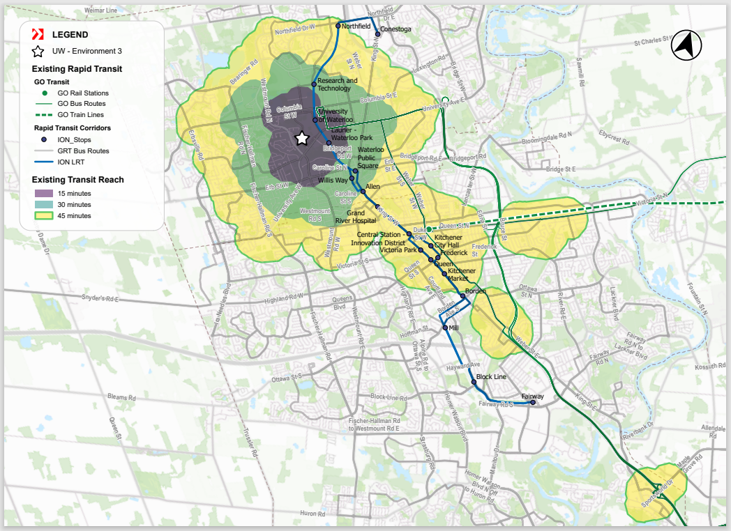
My name is Harry, and I am currently on my third co-op term working as a Spatial Data Analyst with BA Group’s GIS team. BA Group provides transportation planning and engineering services to public and private organizations for the movement of people and goods in urban environments. The primary focus of my work revolves around conducting […]
Read More
 Prediction of Urban Building Permits: Forest-based Classification and Regression (Calgary, Canada)
Posted 5 days ago
By Marjan Jahanbani in the UCalgary Blog
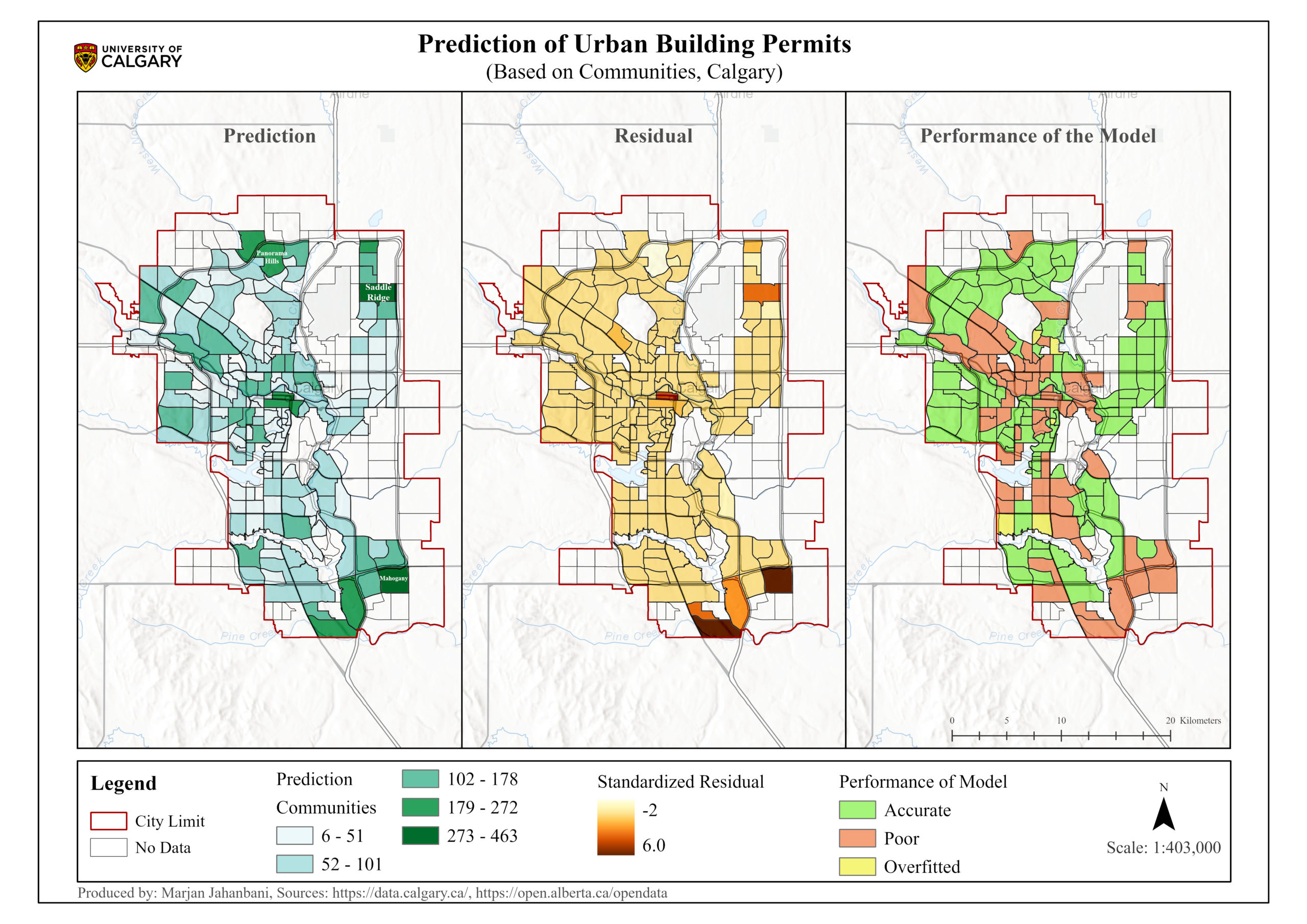
This blog post represents the application of Forest-based classification and regression in th estimation of Calgary's building permits.
Read More
 GIS Insights for School Safety and Active Transportation
Posted 2 months ago
By Shahrzad Sarabi in the UCalgary Blog
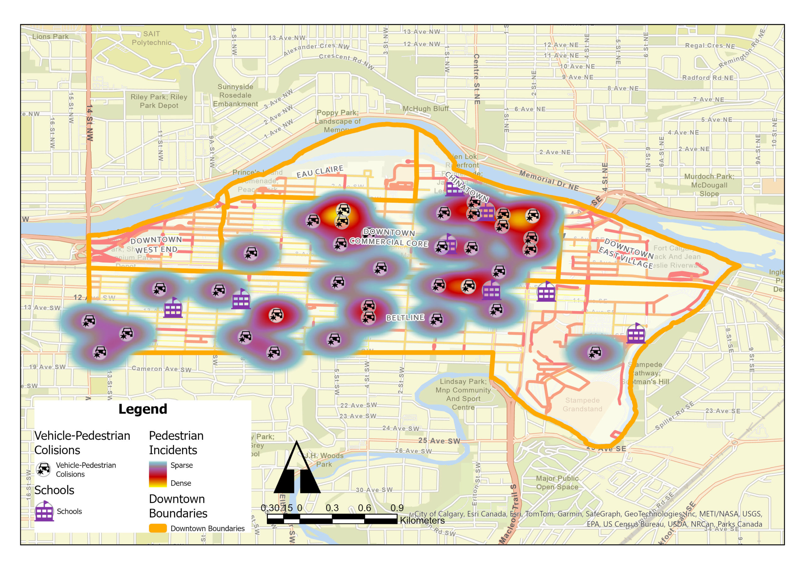
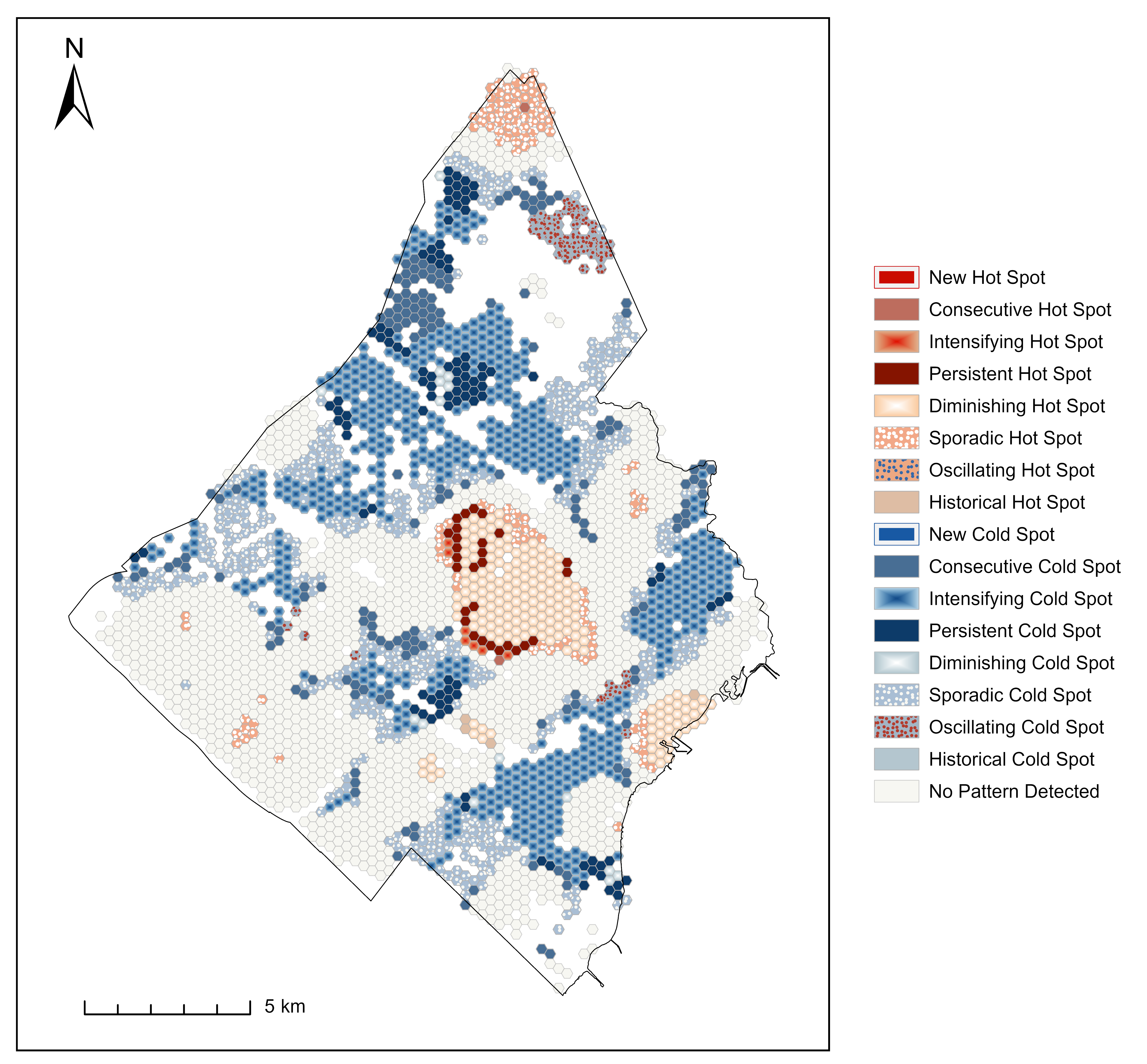
Identification of Collision Hotspots and Risk Levels for Pedestrian Safety in School Zones in Downtown Calgary Introduction In the dynamic urban landscape of downtown Calgary, ensuring pedestrian safety, especially in school zones, emerges as a critical challenge. My study employed Geographic Information Systems (GIS) tools for an extensive analysis of pedestrian-vehicle collision data, focusing on […]
Read More
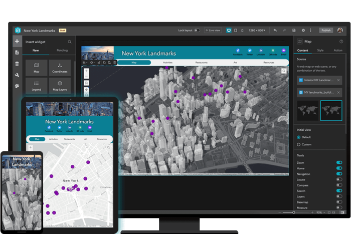 Gaining more experience with Experience Builder: Building Web Apps with ArcGIS Experience Builder
Posted 3 months ago
By Alex Furukawa in the McMaster Blog
Recently, as an ECCE associate I was fortunate to be able to partake in a two-day course offered by Esri Canada: Building Web Apps with ArcGIS Experience Builder. While I have dabbled a bit in the self-guided lesson options available through the Esri Course Catalogue, this was the first instructor-led course for me (and the […]
Read More
 Unveiling Parking Ticket Disparities in Mississauga, Ontario, Canada
Posted 3 months ago
By Scarlett Rakowska in the UofT Blog
This blog will present the findings from a project completed during a graduate course, co-authored with Leila Denise Uy. A parking ticket is a citation for an inactive motor vehicle violating local laws, such as parking in a prohibited space or an unauthorized manner (Mucciolo et al., 2023). Usually, tickets are issued by police officers […]
Read More
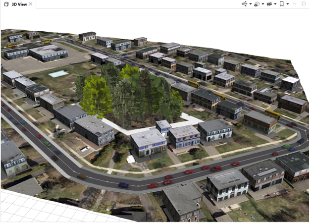 Creating a 3D City Model with ArcGIS CityEngine
Posted 3 months ago
By Ngoc Phan in the UNB Blog
This post demonstrates the process of constructing a 3D city model using ArcGIS CityEngine, leveraging data from sources like OpenStreetMap, including network, footprint, and terrain databases. The project is a component of the “3D Geographical Information Systems” course at the Geodesy and Geomatics Department, University of New Brunswick. 1. Collecting data Using the “Get Map […]
Read More
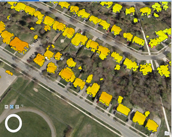 LOD1 Generation Using ArcGIS Pro
Posted 3 months ago
By Ngoc Phan in the UNB Blog
This article aims to provide insights into LOD1 generation utilizing ArcGIS Pro within the context of the “3D Geographical Information Systems” course offered by the Geodesy and Geomatics Department at the University of New Brunswick. The process of constructing LOD1 involves three fundamental steps outlined below. 1. Understanding LOD1 LOD1, or Level of Detail 1, […]
Read More
 Remote and Direct Sensing: Merits of Mixed Method Protocols in Ecology
Posted 3 months ago
By Charlotte Kafka-Gibbons in the UofT Blog
This summer I had the opportunity to design and carry out a week-long research project at the Rocky Mountain Biological Laboratory (RMBL) in Gothic, Colorado—as part of an ecology and evolutionary biology field course. RMBL is a renowned site for long-term ecological research, especially that pertaining to global climatic change. Gothic is situated in a […]
Read More
 Using GitHub Desktop to Share and Collaboratively Develop Experience Builder Widgets
Posted 3 months ago
By Ben Woodward in the UW Blog
In this short post, I am going to extend my earlier tutorial on ArcGIS Experience Builder Dev Edition by showing you how to use GitHub Desktop to share and collaboratively develop your Experience Builder widgets. Why use GitHub GitHub allows you to upload copies of your codebase online in repositories. These repositories provide a backup […]
Read More
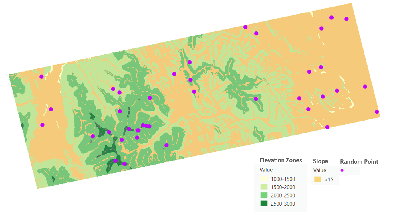 Empowering GIS Workflows: Python and ArcGIS Pro Synergy
Posted 4 months ago
By Shahrzad Sarabi in the UCalgary Blog
Introduction In the Fall semester of 2023, as part of the “Introduction to Programming in Geographic Information” course, a comprehensive project was undertaken: the creation of a Stratified Random Sampling Tool using Python within ArcGIS Pro. This tool was designed to aid soil scientists in selecting optimal sampling locations for a hypothetical research project focused […]
Read More

