 Unveiling Parking Ticket Disparities in Mississauga, Ontario, Canada
Posted 6 months ago
By Scarlett Rakowska
This blog will present the findings from a project completed during a graduate course, co-authored with Leila Denise Uy. A parking ticket is a citation for an inactive motor vehicle violating local laws, such as parking in a prohibited space or an unauthorized manner (Mucciolo et al., 2023). Usually, tickets are issued by police officers […]
Read More
 Collecting and Calculating Land Data – Preparing for Analysis of Remote Sensing Microscale Urban Heat
Posted 2 years ago
By Scarlett Rakowska
A few months ago, I wrote a blog post introducing my MSc Thesis. Since then, I finished my summer fieldwork which consisted of cycling over 560 kilometres of cycling and road infrastructure measuring air temperature every 1-second in Mississauga, Ontario. I also had the opportunity to present my preliminary thoughts on this project at the […]
Read More
 Exploring Cycle-Level Heat – Preparing for Analysis of Remote Sensing Microscale Urban Heat
Posted 2 years ago
By Scarlett Rakowska
This blog post will present my current MSc Thesis project. As human population increases, we are seeing a trend towards more people living in cities than in rural areas (Hiemstra et al., 2017). In 1861, 16% of Canadians lived in urban regions; whereas, in 2011, 81.5% lives in urban regions (Statistics Canada, 2018). Urban areas […]
Read More
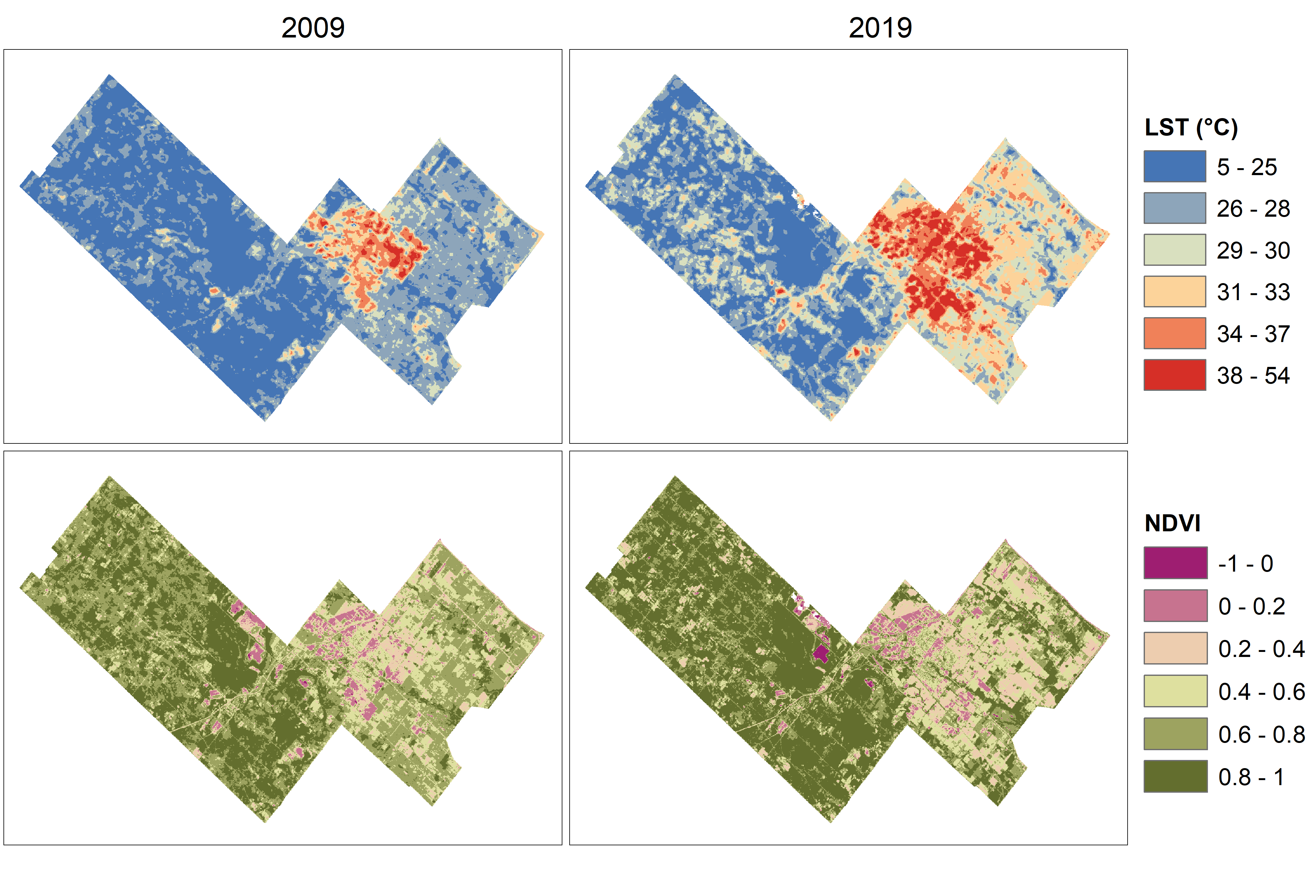 Temperature and vegetation variation within a rapidly growing town
Posted 2 years ago
By Scarlett Rakowska
As a first-year MSc student at the University of Toronto Mississauga, I wrote a paper for a planning course where I integrated remote sensing data with planning documents to understand environmental change in the rapidly growing Town of Milton, Ontario. In this blog post, I will summarize the paper including my methods and findings. However, […]
Read More
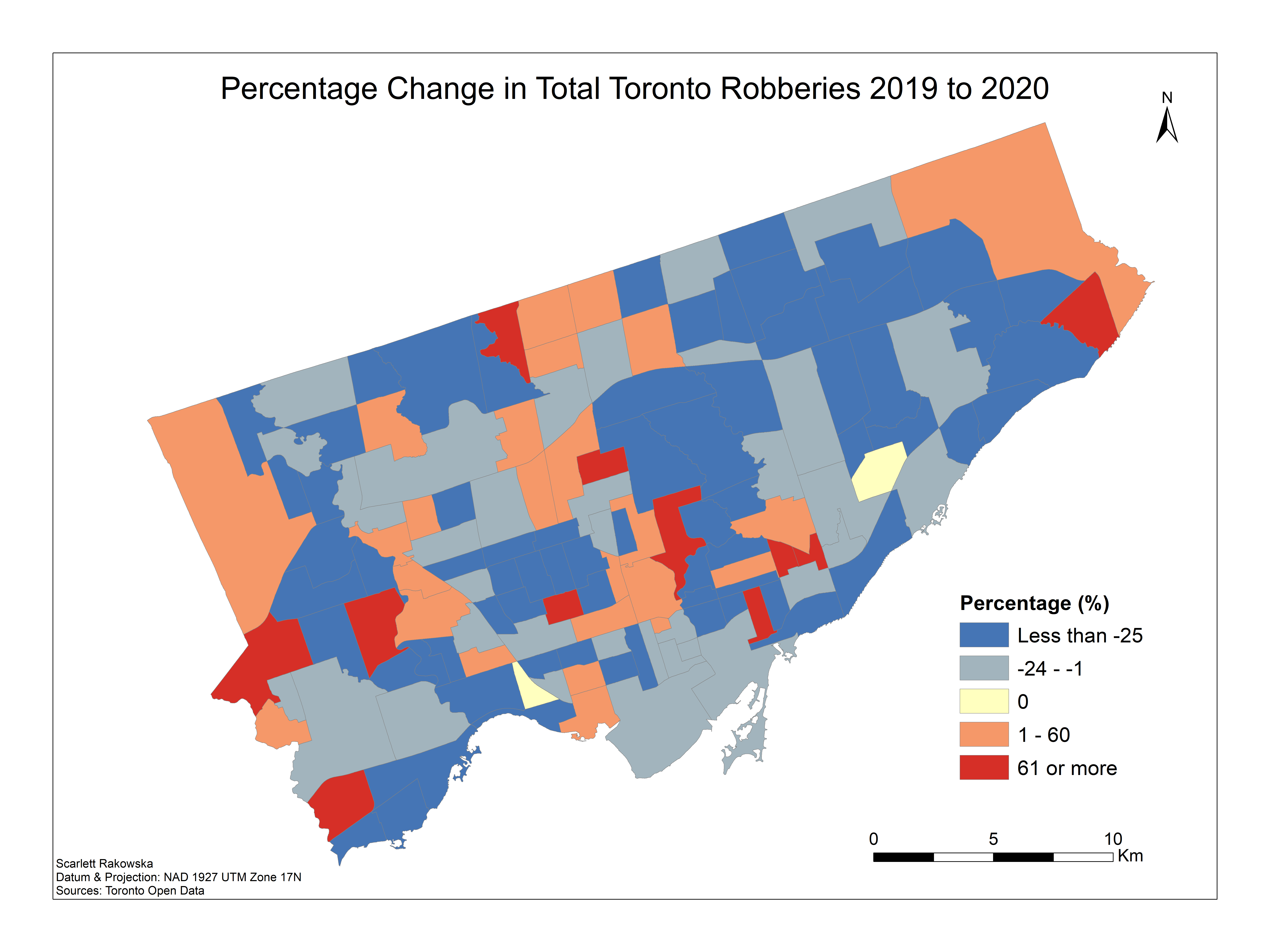 Analyzing the Change in Toronto Crime Data from COVID-19
Posted 3 years ago
By Scarlett Rakowska
About a year ago, I wrote a blog post analyzing Toronto Crime Data using Kernel Density from the 2019 data of major crime indicators. After the COVID-19 restrictions were put in place in March 2020 for the city of Toronto, I was curious to see the changes in crime in Toronto from 2019 to 2020. […]
Read More
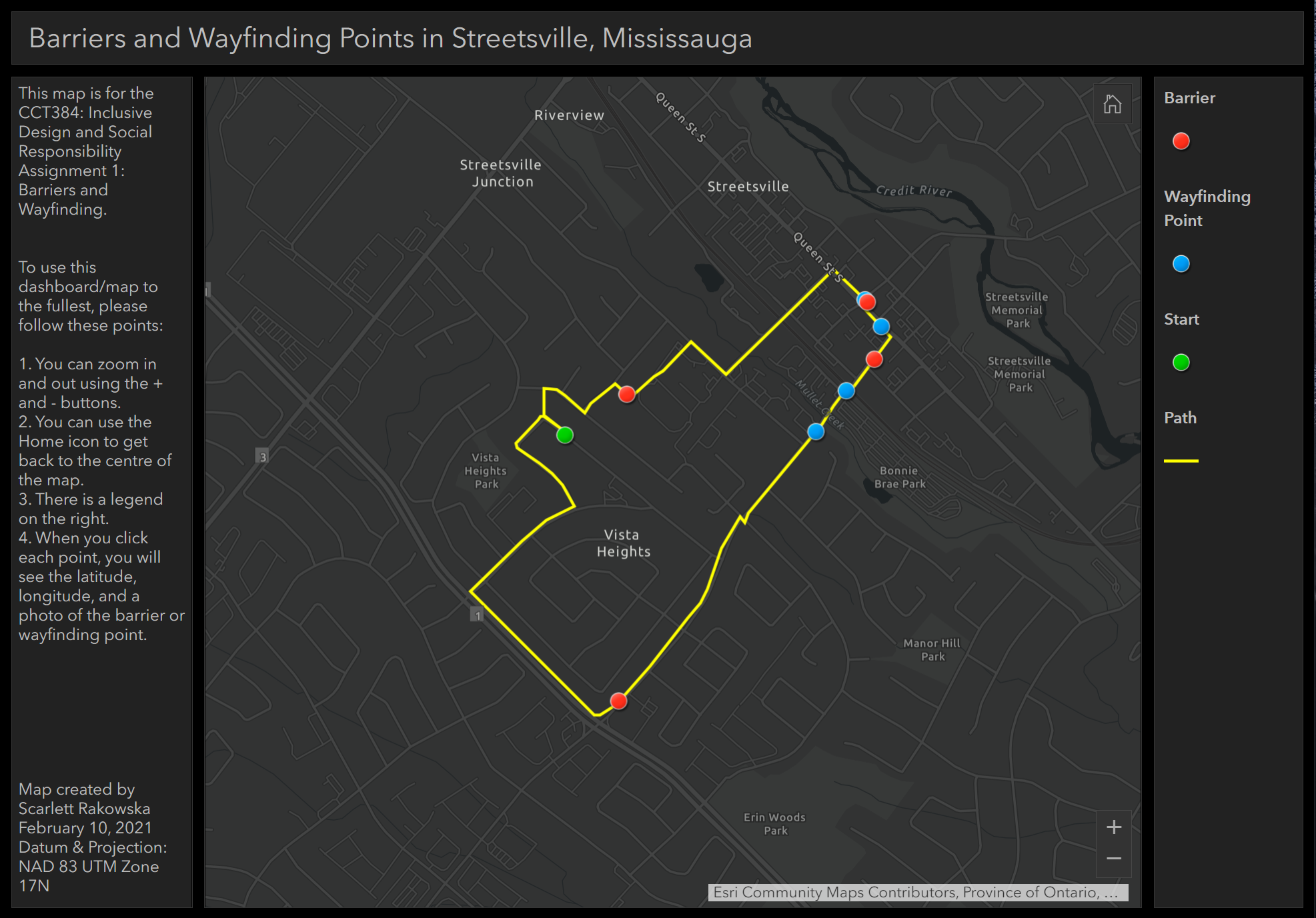 Utilizing GIS in other disciplines: Implementing photos in webmap pop-ups
Posted 3 years ago
By Scarlett Rakowska
As an undergraduate student at the University of Toronto Mississauga (UTM), I am double majoring in Geographical Information Systems (GIS) and Communication, Culture, Information, and Technology (CCIT). I am currently taking a CCIT course that involves inclusive design and social responsibility. For one of the assignments, we had to walk around our neighbourhood and take […]
Read More
 Manually Geocoding – Preparing for Analysis of Green Space Accessibility in Ontario Elementary Schools and Student Performance
Posted 4 years ago
By Scarlett Rakowska
Learn how UTM student Scarlett Rakowska performed manual quality control to augment address geocoding output to get accuracy needed for subsequent analysis.
Read More
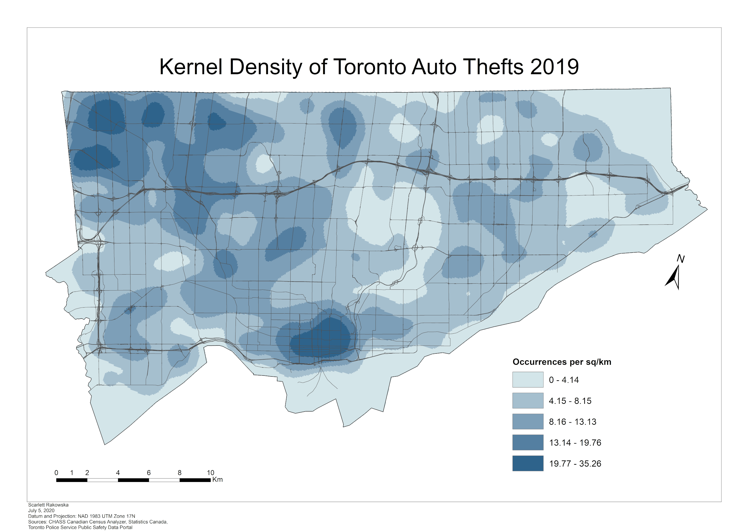 Analyzing Toronto Crime Data using Kernel Density
Posted 4 years ago
By Scarlett Rakowska
Recently, the Toronto Police Service released its 2019 data of major crime indicators. These indicators include assaults, auto thefts, break and enters, homicides, robberies, and thefts over. In this blog, I will analyze the major crime indicators for Toronto in 2019 using kernel density. Kernel Density Kernel Density is a spatial analyst tool that calculates […]
Read More
 COVID-19 Web Mapping Application: step-by-step
Posted 4 years ago
By Scarlett Rakowska
Hello, My name is Scarlett, and I am a third-year undergraduate student at the University of Toronto Mississauga, studying Geographical Information Systems (GIS). After the World Health Organization announced COVID-19 a pandemic, on March 19, 2020, I viewed an Esri Canada webinar presented by Chris North and Mike Gregotski called “Responding to the COVID-19 Crisis […]
Read More

