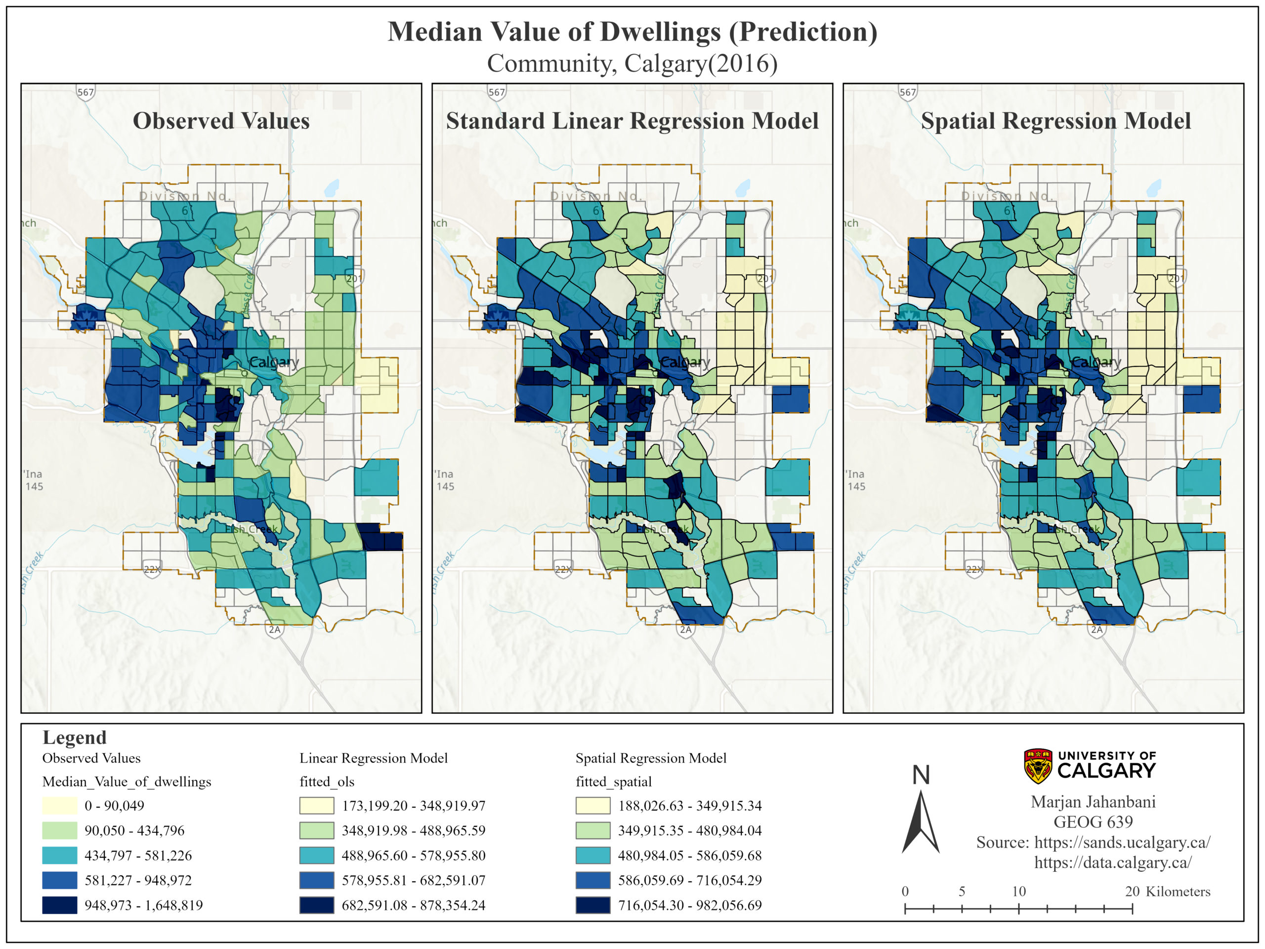
 Evaluation of influential variables on Calgary’s dwelling price (Spatial Autoregressive Model)
Posted 1 month ago
By Marjan Jahanbani in the UCalgary Blog
demands as well as the communities’ needs. This project aims to describe the relationship of some influential socio-economic variables on the median value of dwellings in Calgary based on the community census data (2016).
Read More
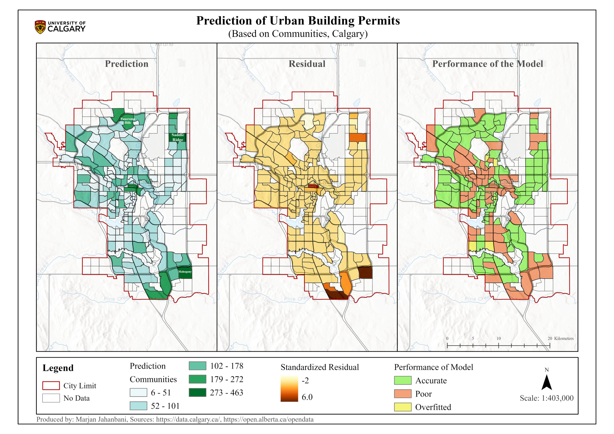 Prediction of Urban Building Permits: Forest-based Classification and Regression (Calgary, Canada)
Posted 3 months ago
By Marjan Jahanbani in the UCalgary Blog
This blog post represents the application of Forest-based classification and regression in th estimation of Calgary's building permits.
Read More
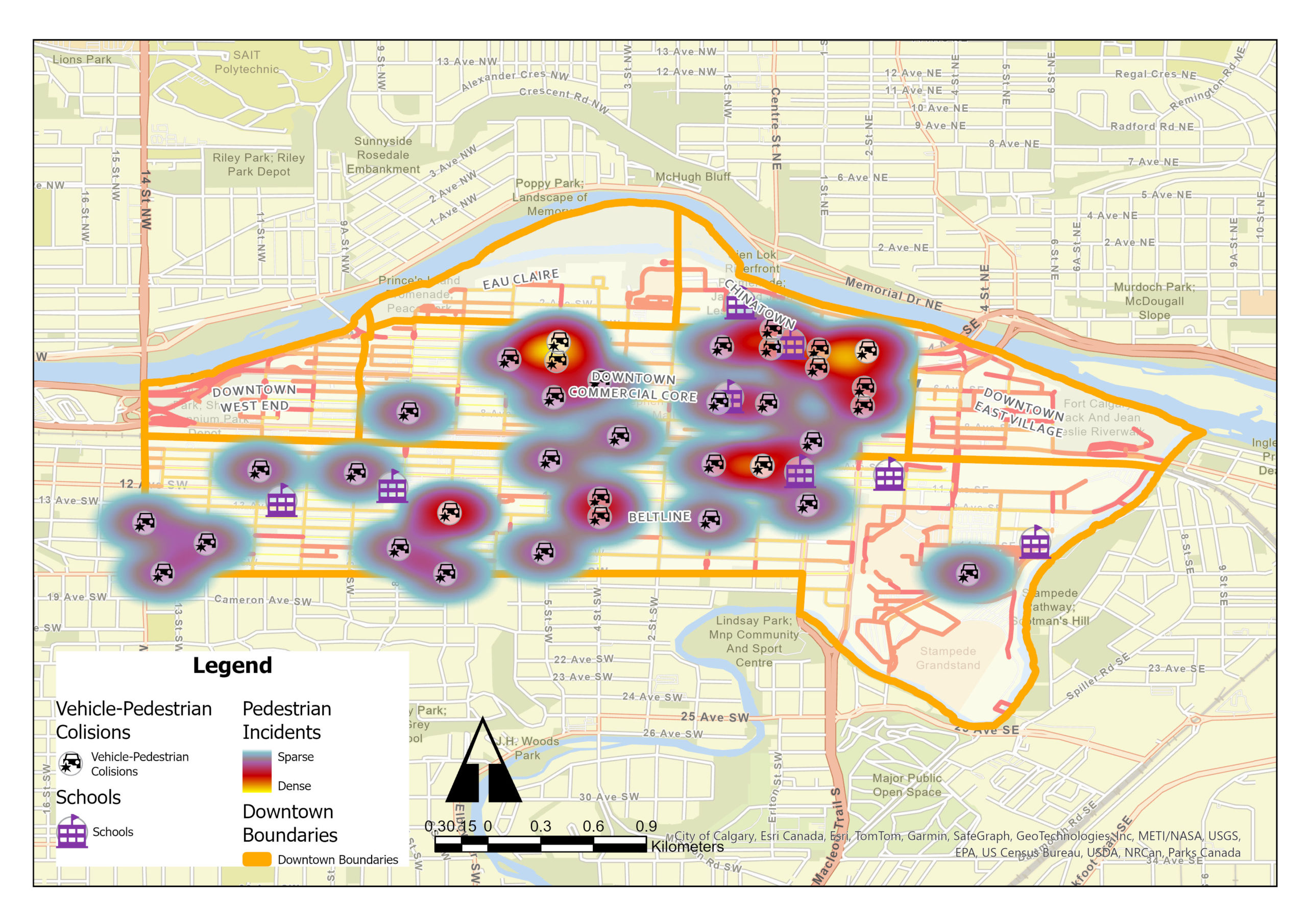 GIS Insights for School Safety and Active Transportation
Posted 5 months ago
By Shahrzad Sarabi in the UCalgary Blog
Identification of Collision Hotspots and Risk Levels for Pedestrian Safety in School Zones in Downtown Calgary Introduction In the dynamic urban landscape of downtown Calgary, ensuring pedestrian safety, especially in school zones, emerges as a critical challenge. My study employed Geographic Information Systems (GIS) tools for an extensive analysis of pedestrian-vehicle collision data, focusing on […]
Read More
 Empowering GIS Workflows: Python and ArcGIS Pro Synergy
Posted 7 months ago
By Shahrzad Sarabi in the UCalgary Blog
Introduction In the Fall semester of 2023, as part of the “Introduction to Programming in Geographic Information” course, a comprehensive project was undertaken: the creation of a Stratified Random Sampling Tool using Python within ArcGIS Pro. This tool was designed to aid soil scientists in selecting optimal sampling locations for a hypothetical research project focused […]
Read More
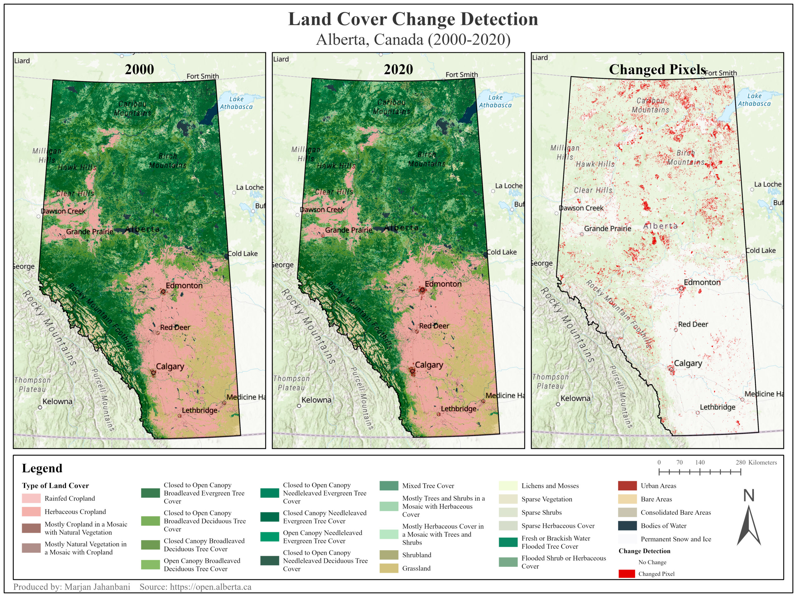 Land-Cover Change Detection in Alberta, Canada (2000-2020)
Posted 8 months ago
By Marjan Jahanbani in the UCalgary Blog
This post illustrates the transformation of land cover in Alberta Province (Canada) over 20 years.
Read More
 Mapping Inclusivity: Esri Canada Competitions and Advancing Gender-Inclusive Campus Design
Posted 11 months ago
By Hawjin Falahatkar in the UCalgary Blog
Hello everyone! My name is Hawjin Falahatkar, and I am currently pursuing an M.Sc. in Geography at the University of Calgary, working in the Fast Accessible Mapping & Mobility (FAMM) research lab directed by Dr. Victoria Fast. Drawing from an urban planning and design background and an interest in accessibility research, I employ the power […]
Read More
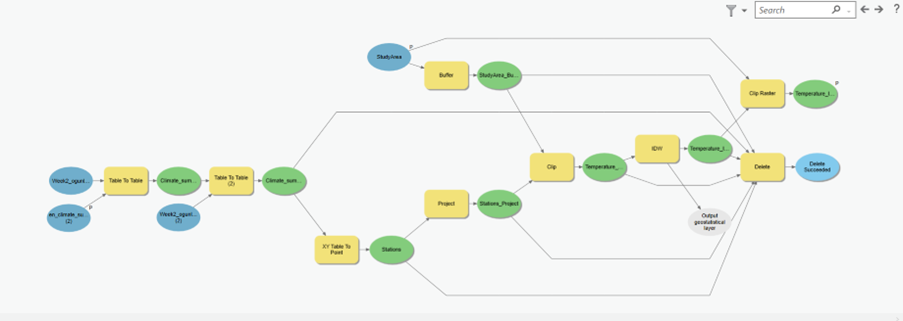 Working smarter, not harder, with ArcGIS ModelBuilder
Posted 1 year ago
By olusegun ogunleye in the UCalgary Blog
I was introduced to ArcGIS ModelBuilder during a course lab where we were asked to design a model which could enable the interpolation of temperature values for Alberta and Saskatchewan. Aside from ensuring consistency, efficiency, and effectiveness, the ModelBuilder aids the visualization of the workflow, allows modification by setting inputs and outputs as parameters, and […]
Read More
 Apply to become a Student Assistant at the 2023 Esri User Conference in San Diego
Posted 2 years ago
By Maja Kucharczyk in the UCalgary Blog
Happy new year, everyone! My name is Maja Kucharczyk and I am a PhD candidate in Geography at the University of Calgary. This is my first blog post as an ECCE Student Associate. I very much look forward to continuing my GIS journey in 2023, especially when I look back on the opportunities I had […]
Read More
 Developing a Better Appreciation of the Value of a Geographical Approach Through the Use of ArcGIS
Posted 2 years ago
By olusegun ogunleye in the UCalgary Blog
I always wanted to acquire GIS capabilities, but my busy schedule as an urban development practitioner did not permit me. However, the advent of big data and the need to remain competitive in the ever-changing global labor market was the push required to embark on the Master of GIS program at the University of Calgary. […]
Read More
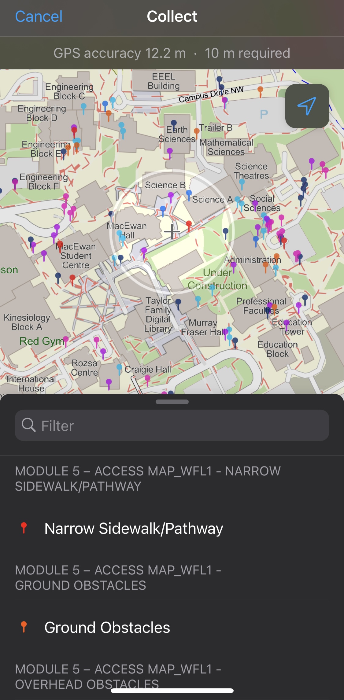 Using ArcGIS Field Maps to Collect Data on Sidewalk Obstacles in Calgary, Alberta, Canada
Posted 2 years ago
By Yui Tanagi in the UCalgary Blog
As a Master of Geographic Information Systems (MGIS) Student and a research assistant for Dr. Victoria Fast at the University of Calgary, I had the opportunity to assist in setting up and leading a module for undergraduate students that would require them to recognize barriers in the built environment that would affect the accessibility of […]
Read More

