
Mapping Inclusivity: Esri Canada Competitions and Advancing Gender-Inclusive Campus Design
Hello everyone!
My name is Hawjin Falahatkar, and I am currently pursuing an M.Sc. in Geography at the University of Calgary, working in the Fast Accessible Mapping & Mobility (FAMM) research lab directed by Dr. Victoria Fast. Drawing from an urban planning and design background and an interest in accessibility research, I employ the power of ESRI technology in combining geospatial data science within the realm of environmental planning and design to create more inclusive and accessible urban spaces for all.
In this blog post, I would like to share my journey in participation in both the “2023 Esri Canada GIS Scholarship at the University of Calgary” and the “2023 Esri Young Scholar Award.” Through these experiences, I have delved into the realm of geospatial big data and computational methodologies to promote more gender-inclusive campus outdoor places, working on UCalgary’s main campus.
Promoting Gender Inclusivity on the UCalgary Campus: The Role of Esri Technology
We use university campus areas daily and understand their critical role in supporting our everyday ordinary activities like walking, sitting, recreating, socially interacting, and experiencing educational and urban life. For campuses to be accessible for all genders, they need to include or exclude some physical features, as space aids and barriers to accessibility, what we call gender-inclusive physical features in our research. Gender-inclusive physical features make campus areas support not only mobility but also stayability; meaning that they are safe, comfortable, and welcoming for all individuals to find, reach and use by providing transportation services, appropriate lighting, toilets, adequate rest areas and seating, and availability of ramps, accessible entrances, and elevators for people with differential movement abilities, like wheelchairs users and caregivers with strollers. These features, in fact, enhance the sense of safety and equity for all genders while being on campus and enjoying their educational life.
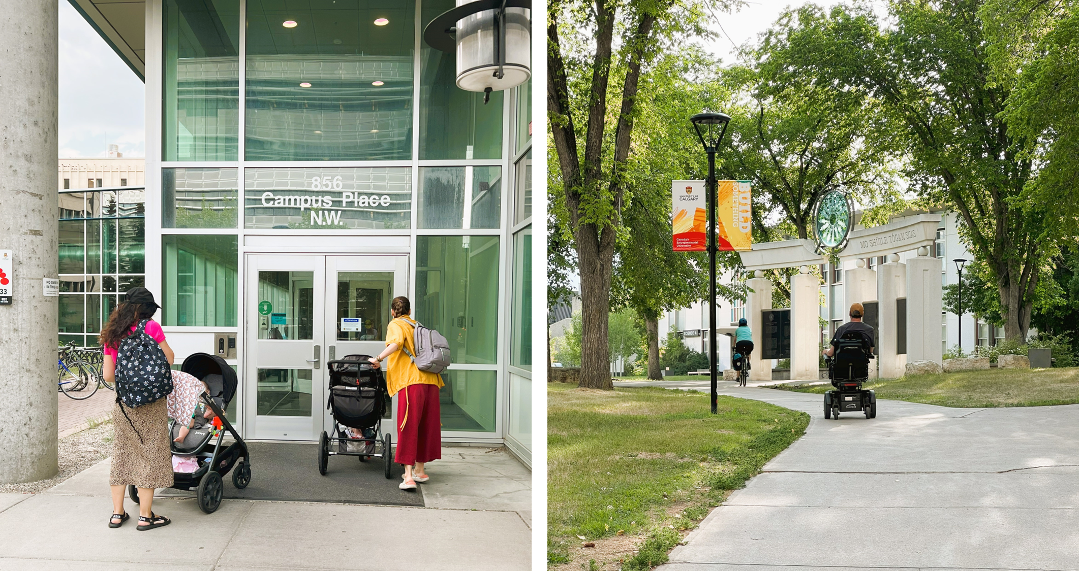
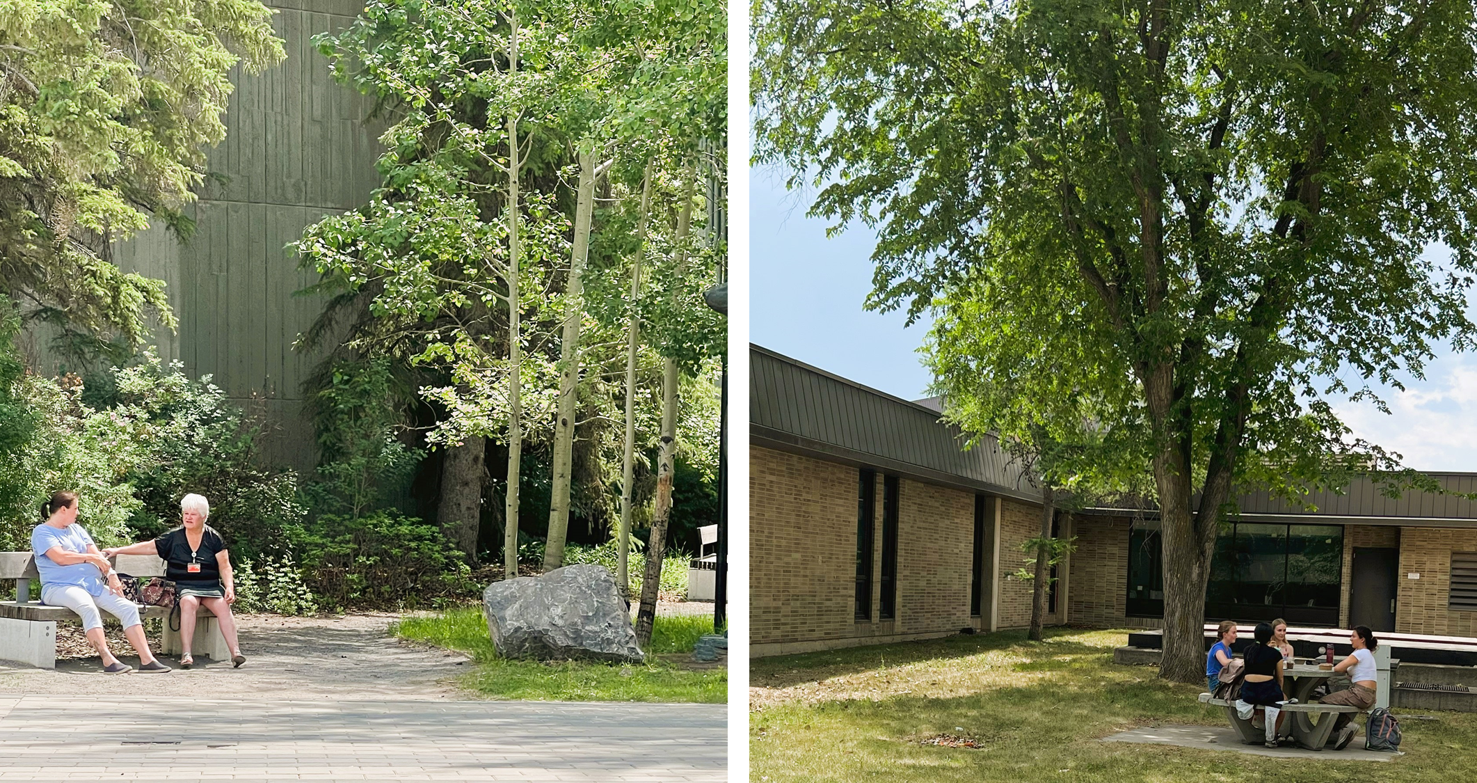
In this context, we aim to find and analyze gender-inclusive features of open spaces of UCalgary’s main campus to evaluate how the space is accessible to all genders. The purpose is to assess how these spaces are accommodating and welcoming to individuals of all genders. To achieve this, we employ a computational urban design analysis in which gender-inclusive features of the study site will be mapped and analyzed using ArcGIS Pro and other Esri technologies. The mapping process involves marking specific points, lines or polygons on a map to represent various gender-inclusive attributes or facilities. These could include gender-neutral washrooms, accessible pathways, seating areas designed to accommodate women’s expressions, and more. Given the diversity of these features and their varying scales, we collect data from a range of datasets, including shapefiles, imagery, LiDAR, etc., obtained from a hierarchy of data sources, ranging from secondary to primary. By layering this information onto the map, along with other descriptive data layers, we are able to gain insights into the presence/absence, distribution, and effectiveness of gender-inclusive features across the campus.
For a more in-depth understanding of gender-inclusive physical features, I recommend referring to our recently published paper, which can be accessed here.
My Journey in the Esri Canada Awards Competition
The 2023 Esri Canada GIS Scholarship
The Esri Canada GIS Scholarship prize acknowledges the exceptional academic performance of the students who integrate geographic information systems (GIS) into their academic pursuits. Sponsored by Esri Canada, this award necessitates students to showcase how their utilization of Esri technology (such as the ArcGIS Platform) has notably enhanced a recent coursework or research project. Annually, awards are open to qualified university students. As a UCalgary student, I achieved the 2023 Esri Canada GIS Scholarship at the University of Calgary.
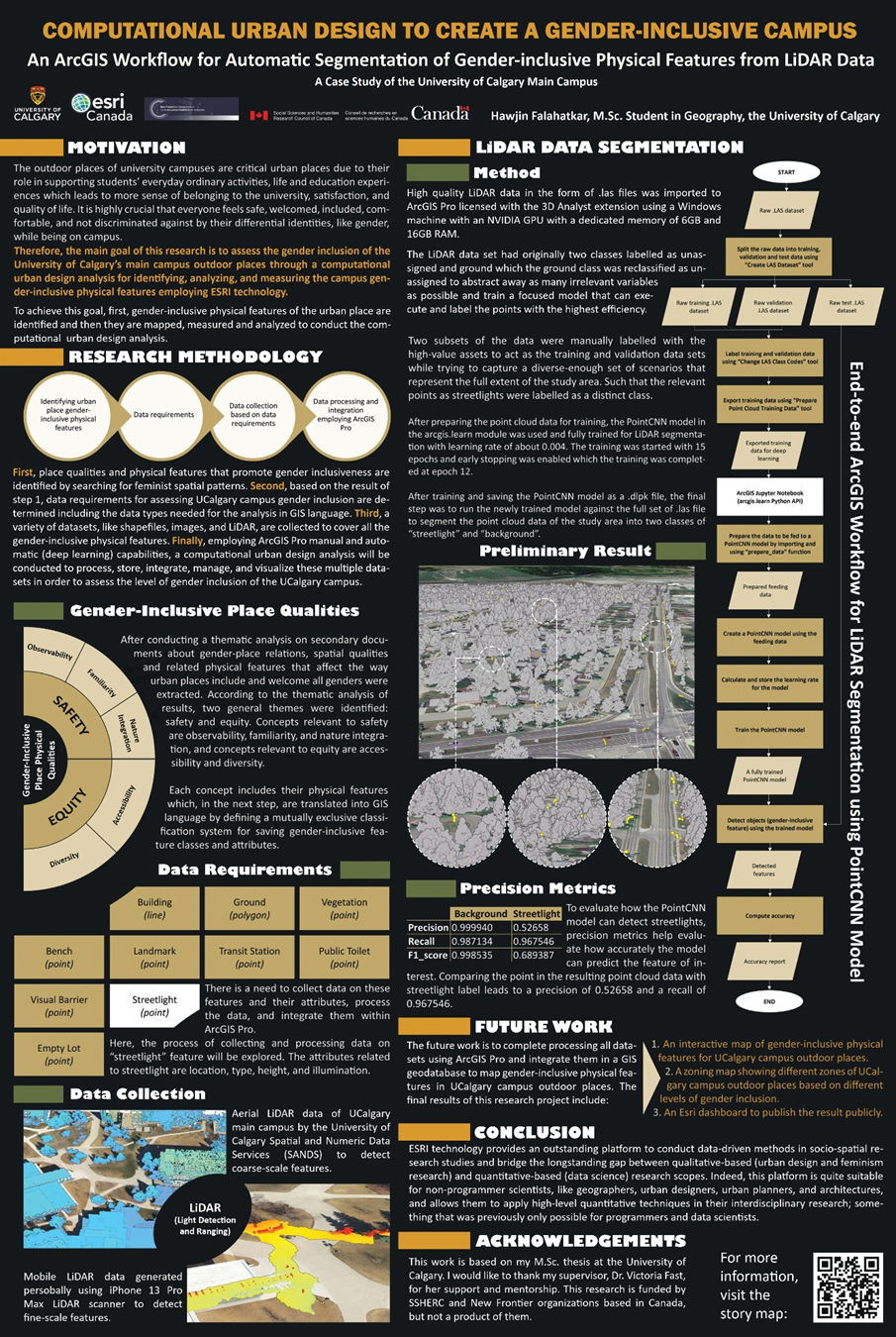
The competition has two rounds. As the main requirement of the first round, students usually have the choice to create an ArcGIS StoryMap or a 10-page project report, which I chose the second option. Since the competition was more about applying high-level Esri technology, for the report, I highlighted the aspect of my research in which I utilized ArcGIS Pro’s advanced automated techniques. Specifically, I focused on using the PointCNN model, as a semantic segmentation deep learning model, to detect fine-scale gender-inclusive features like streetlights and benches from LiDAR (Light Detection and Ranging) data.
After about two weeks, I was notified that I was one of the finalists and invited to submit a digital poster in the second round. I created an illustrative poster summarizing the process and outcomes of my research project. The poster kicks off with a comprehensive research overview, followed by an in-depth exploration of the intricate process of streetlight extraction from LiDAR data, including methods and preliminary results. This experience highlighted the transformative potential of ArcGIS Pro’s advanced technologies in shaping the future of urban planning and reaffirmed my dedication to fostering more inclusive and accessible urban environments using data-driven methods. You can find the PDF file of the poster here.
The 2023 Esri Young Scholar Award
The Esri Young Scholars Award initiative acknowledges the outstanding achievements in the field of geospatial sciences by both undergraduate and graduate students from various global universities. In Canada, the Esri Young Scholar is determined through a competition that invites participation from all full-time students currently enrolled in Canadian colleges and universities. Here, you can find the award website for more information. As a result of my participation, I earned the third-place prize in the 2023 Esri Young Scholar Award. To discover more about my work and access additional information, feel free to explore my ESRI account profile, available here.
To compete for this award, the main requirements were an ArcGIS StoryMap and a digital poster. I used the same part of the project that I highlighted in the 2023 Esri Canada GIS Scholarship competition and crafted an ArcGIS StoryMap that offered a comprehensive snapshot of my research journey, which you can access here. Within this interactive platform, I intricately outlined the advanced methodologies I employed to segment LiDAR data and the preliminary results, showcasing its pivotal role in detecting gender-inclusive physical features like streetlights. For designing the StoryMap, I tried to use a variety of tools and functions, like maps, images, videos, texts, charts, and tables, to create an attractive and understandable narrative that makes audiences eagerly engage and delve into the journey of my project. Moreover, for the digital poster, I made slight revisions and submitted the version originally created for the Esri Canada GIS Scholarship application.
Final Words
In this blog post, I’ve recounted my participation in and reception of the “2023 Esri Canada GIS Scholarship” and the “2023 Esri Young Scholar Award,” which allowed me to explore geospatial big data and computational methods for enhancing gender inclusivity within the UCalgary’s outdoor spaces. I showed how utilizing ArcGIS Pro’s range of capabilities, from manual to automated methods, facilitated the mapping and measurement of gender-inclusive features, enabling a comprehensive computational urban design analysis to assess the campus’s inclusivity and accessibility for all. In addition to the valuable prize packages I received, this journey led to significant personal growth and learning, enabling me to forge a stronger connection with my research while also enhancing my ability to effectively communicate it with different audiences through diverse methods such as reports, posters, and StoryMaps. The implications of this work extend to future directions, as I plan to further explore mapping and analyzing all the gender-inclusive features, while also exploring other Esri capabilities that can empower me to undertake multidisciplinary socio-spatial research studies.
Acknowledgement
I would like to acknowledge that this work is based on my M.Sc. thesis at the University of Calgary, and I extend my sincere appreciation to my supervisor, Dr. Victoria Fast, for her invaluable support and mentorship.
References
Falahatkar, H., & Fast, V. (2023). A Feminist-driven Computational Urban Design Framework for Mapping Gender-Inclusive Urban Places. Proceedings of the 18th International Conference on Computational Urban Planning and Urban Management (CUPUM). https://osf.io/cxy42
Falahatkar, H., & Fast, V. (2022). Extending the Conversation: A Vision for Urban Accessibility for Diverse Mobilities through GeoAI. Spatial Data Science Symposium 2022 Short Paper Proceedings.