
Working smarter, not harder, with ArcGIS ModelBuilder
I was introduced to ArcGIS ModelBuilder during a course lab where we were asked to design a model which could enable the interpolation of temperature values for Alberta and Saskatchewan. Aside from ensuring consistency, efficiency, and effectiveness, the ModelBuilder aids the visualization of the workflow, allows modification by setting inputs and outputs as parameters, and it is sharable.
Designing a Model in ModelBuilder
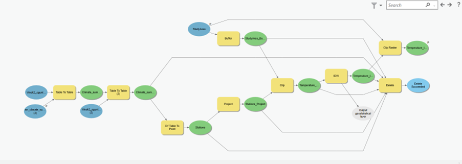
The first step was to design the workflow for the model which aids in identifying and selecting tools to use to perform the different tasks. Once this step was completed, then one can dive into designing the model in ArcGIS ModelBuilder. While it was easy to design the model due to the workflow I had designed, the tricky part was deciding which tools to use because different tools can be used to perform a task. I decided to use the table-to-table tool to bring my file into the ArcGIS environment as well as for data cleaning. Thereafter, I used the XY-to-point tool to transform my table into a point feature class. In addition, I used the buffer and clip tool to create a buffer around my study area. Once, that was done I used the IDW tool to interpolate the temperature points over the surface, and the clip tool to clip the raster to my study area. Last I validated the model and ran it, and viola it was done. I set the study, file selection, and name of the final output as model parameters so a third party can change the study, select another file to use for the interpolation, and define the name of the output file. Additionally, the model can be shared using different methods.

Iterative model
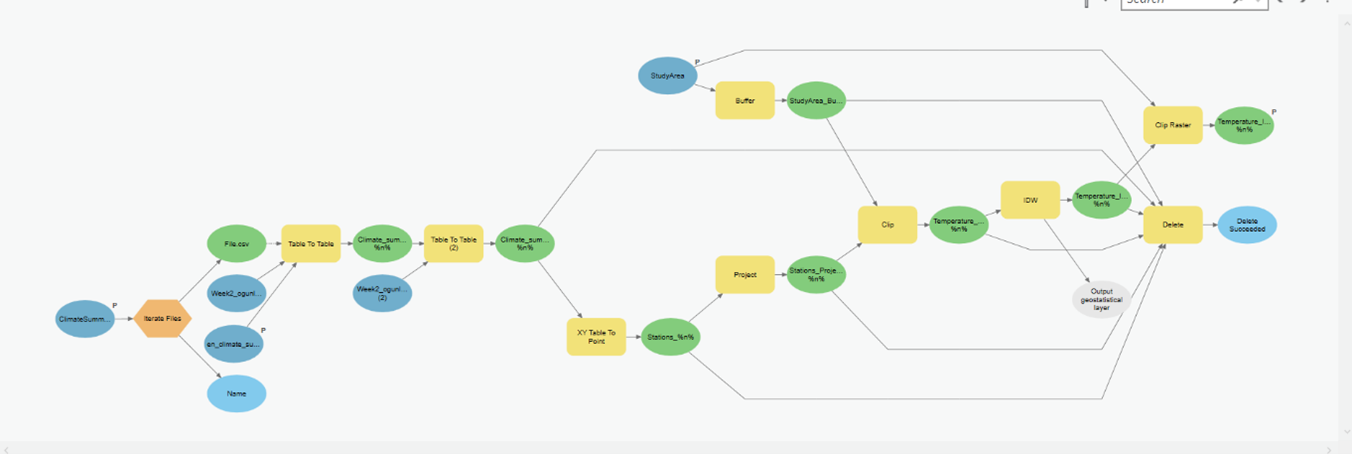
A bonus question was to build an iterative model. It took me two additional steps to achieve this. First, I added a file iterator to my original model. The reason I selected a file iterator was that I designed my model to enable users to select files as input data and not the spreadsheet. The second step was to use inline variable substitution so that the file out could be given distinct names. I then decided to make coffee while the model was working through all the files in the folder.
Using ModelBuilder to develop an automated data-cleaning workflow
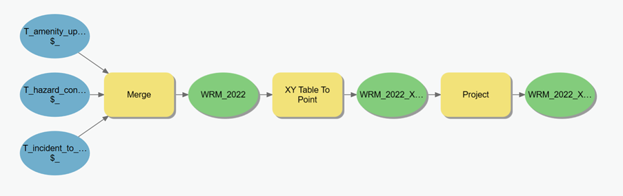
I was intrigued by the outcome above, so I decided to apply it to the WalkRollMap (WRM) datasets I was working with. WalkRollMap.org is a crowdsourcing tool for mapping micro barriers to accessible walking and rolling, and I intended to see how WRM data can be used to inform initiatives aimed at making our cities more inclusive. A major issue I had was pre-processing the datasets because the different files had different numbers of columns and there were a couple of blank spaces. I initially merged and cleaned the Excel sheets using different Excel functions, but this took considerable time and I had to repeat the process each time I received new datasets. So, I decided to do a workflow to design a model. Going through the list of tools I noticed I could use the merge tool to merge Excel sheets, and once that was done, I could do all my visualization within the GIS environment. Also, there was no need to repeat the process each time I obtained new datasets, as the workflow could be automated. Lastly, I can develop the ModelBuilder incrementally to add new functions as needed
Spatial Knowledge and Information (SKI) Conference 2023
While my models were at work, I was planning my trip to the Spatial Knowledge and Information (SKI) Conference 2023 which took place at Banff. It was exciting learning about innovative things others were doing and I left more motivated and convinced about the use of GIS to enhance our understanding of spatial processes as well as finding solutions to different social and environmental issues.