
 Reflecting on the 2021 ECCE App Challenge
Posted 3 years ago
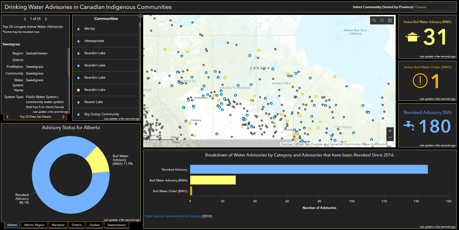
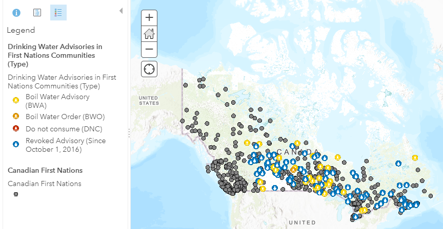
Reflecting on the 2021 ECCE App Challenge as a first-timer where we mapped the problem that Indigenous Canadians continue to face accessing clean water.
 Reflecting on the 2021 ECCE App Challenge
Posted 3 years ago
Reflecting on the 2021 ECCE App Challenge as a first-timer where we mapped the problem that Indigenous Canadians continue to face accessing clean water.
 Reducing Inequalities In Canada – 2021 ECCE App Challenge
Posted 3 years ago
The ECCE App Challenge for 2021 focused on the United Nations Sustainability Goal 10, Reducing Inequality. My name is Chelsea Fitzpatrick (MGIS candidate) and I am one of the ECCE student associates for the Geography Department at the University of Calgary....
 A ‘Mind Map’ of GIScience Basics
Posted 3 years ago
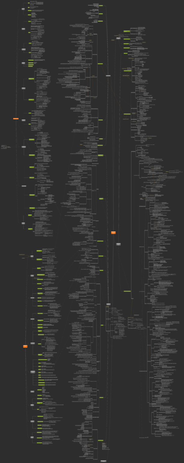
This ‘mind map’ was originally created for my PhD candidacy exam preparation, to help me organize, understand, and memorize knowledge and concepts regarding GIScience. The ‘mind map’ includes four main parts: architecture design, database management systems, geospatial data, and data manipulation. Additionally, I briefly went over the basic concepts and technologies of photogrammetry and digital […]
 Identifying Dense Oil and Gas Producing Regions for Methane Emissions Verification Screenings in Alberta, Canada Using ArcGIS Pro
Posted 3 years ago
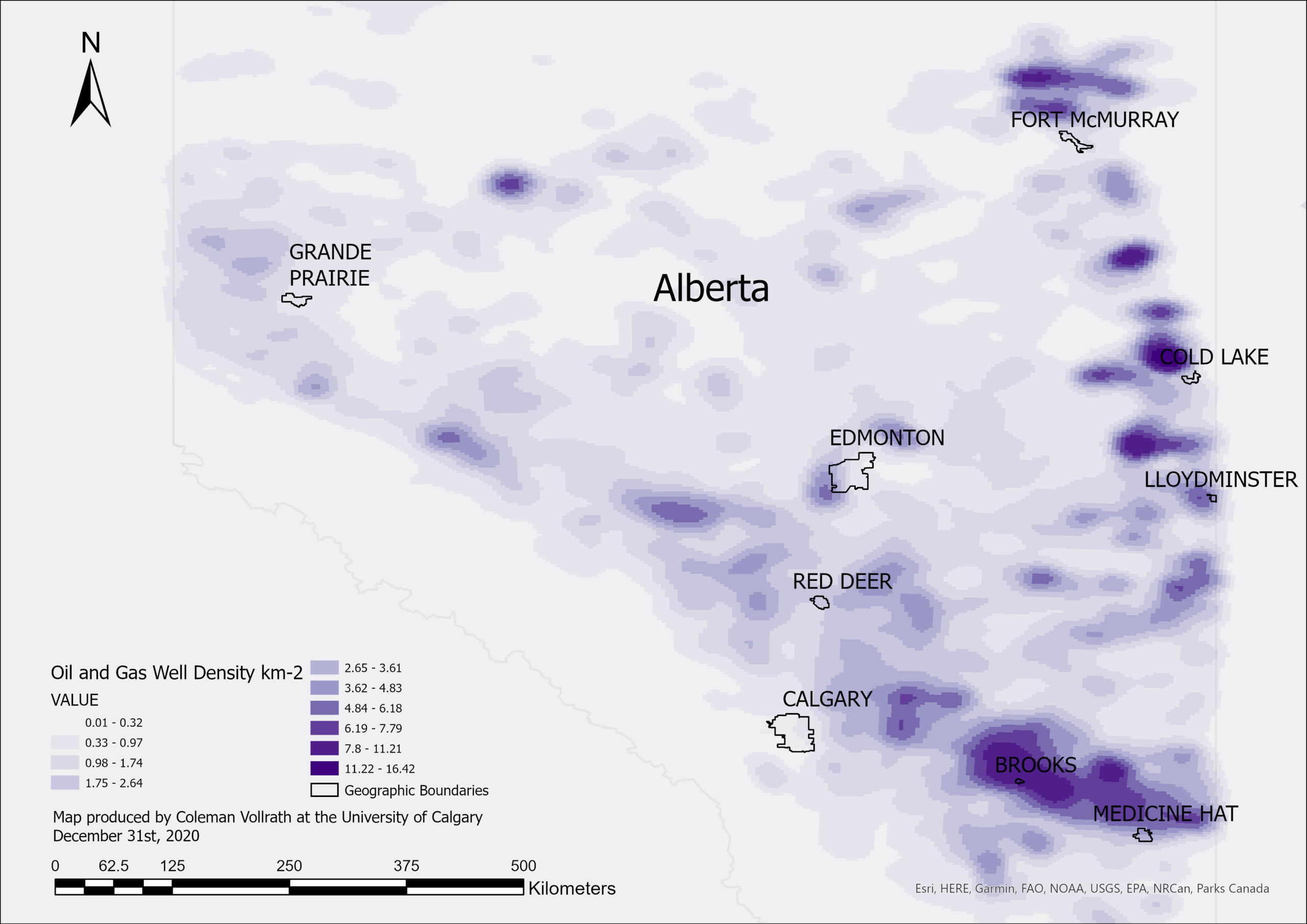
Identifying dense oil and gas producing regions in Alberta for methane emissions verification screenings with kernel density analysis
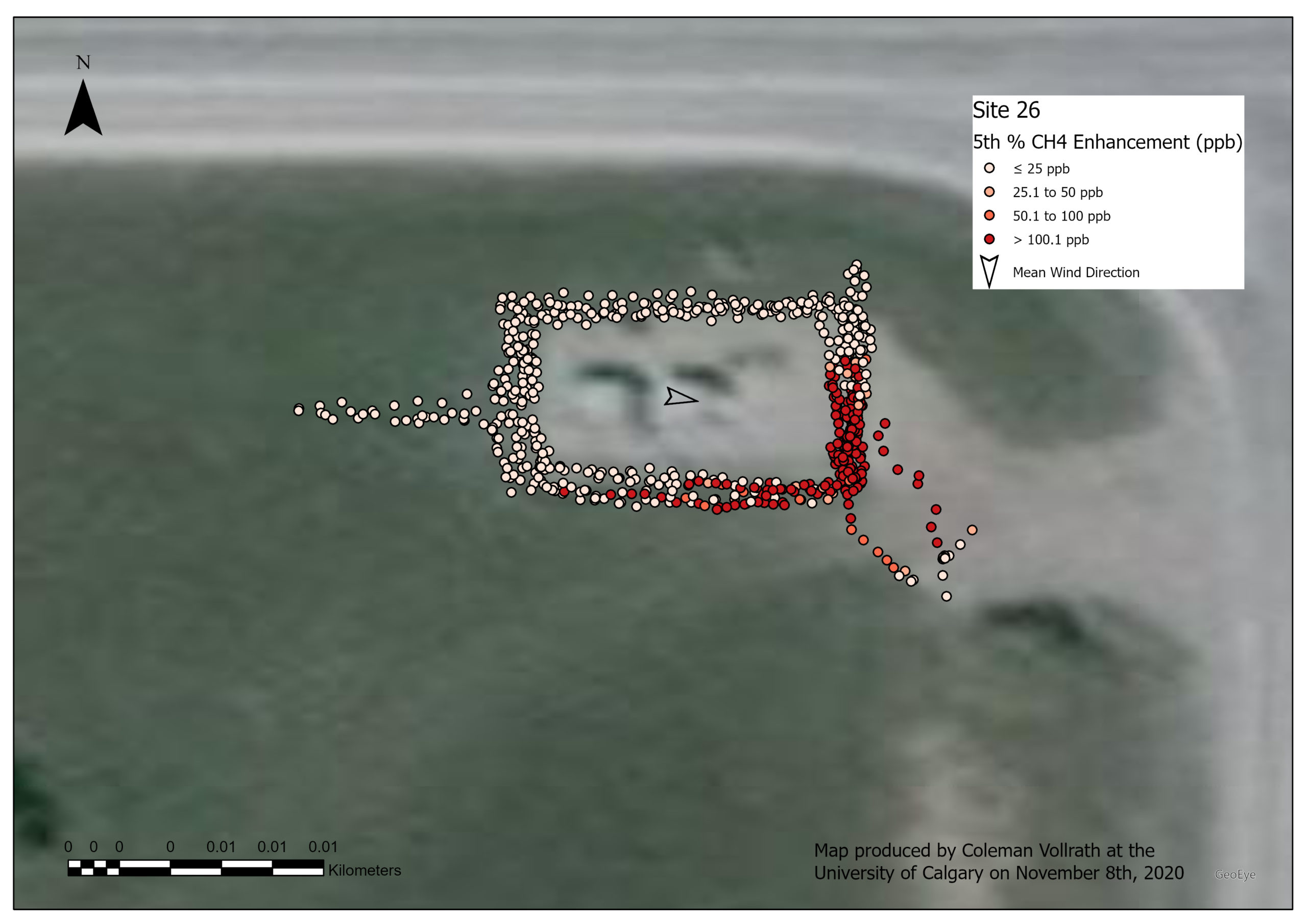 Visualizing Geolocated Methane Concentration Measurements in ArcGIS Pro
Posted 3 years ago
How to use ArcGIS Pro for concentration mapping of methane concentrations measured with a portable device, helping to detect methane leaks from oil and gas production facilities.
 Citizen Science and Survey123
Posted 4 years ago
Last year, I had the privilege of attending the Spatial Knowledge and Information (SKI) conference in Banff with my research team (Figure 1). It was my first time presenting at an academic conference, and overall a splendid experience. We went cross-country skiing and sight-seeing in the mornings and listened to some interesting presentations founded in […]
 Modeling Line Features on DGGS Grids in the R-ArcGIS Environment
Posted 4 years ago
A Glance at DGGS As a candidate for a new Earth reference standard, Discrete Global Grid System (DGGS) was confirmed by the Open Geospatial Consortium (OGC) as “a spatial reference system that uses a hierarchical tessellation of cells to partition and address the globe” in 2017. DGGS has been recognized as the most potential foundation […]
 Get started with the ArcGIS world Geocoding service
Posted 4 years ago
Hello everyone, My name is Changlin and I am a second year masters student from Geomatics Engineering at the University of Calgary. This post is about my recent experience working with the ArcGIS World Geocoding Service to find geographical locations of different places. This experience is related to one of the project tasks of a […]
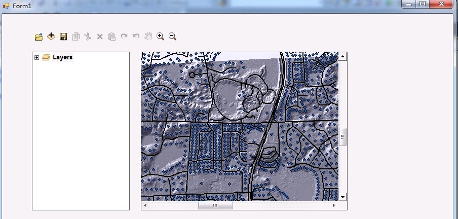 Developing a pipeline monitoring system using ArcGIS Engine
Posted 4 years ago
Hi everyone, In this post, I want to share part of my project experience for developing a pipeline monitoring system using ArcGIS Engine. This project is required by a pipeline management company that monitors for gas leaks from pipelines in the oil and gas industry. As part of the project requirements, the pipeline network should […]
 Mapping Cultural Character
Posted 4 years ago
As a second year Masters of Geographic Information Systems (GIS) student at the University of Calgary, I have applied Esri software to a wide variety of topics and problems, often to areas not traditionally thought of as applicable to GIS. This past summer, I had the opportunity to see how GIS and sociology can come […]