
 Meet the Winners of the ECCE App Challenge 2021
Posted 4 years ago
Meet the winners of the ECCE App Challenge 2021!
 Meet the Winners of the ECCE App Challenge 2021
Posted 4 years ago
Meet the winners of the ECCE App Challenge 2021!
 The Equalizers App Challenge journey – from the view of a first timer
Posted 4 years ago
When my professor emailed me about being an Esri Canada Centres of Excellence Associate, I was initially very excited about the opportunity. However, upon hearing about the App Challenge, though I always think of myself as capable of anything, I honestly thought maybe he rated me a bit too highly and I wasn’t up to […]
 Meet the teams of the ECCE App Challenge 2021
Posted 4 years ago
The annual ECCE App Challenge has recently completed its 7th iteration. Each year this competition provides us with the opportunity to see many new and interesting apps created and presented by teams joining from ECCE schools across the country. In this respect, the 2021 App Challenge was very similar to the previous six competitions. However, […]
 Unprecedented
Posted 4 years ago
If there was one word to describe the last year and three months, or more depending on when you are reading this, it would be “unprecedented”...
 Reducing Inequalities In Canada – 2021 ECCE App Challenge
Posted 4 years ago
The ECCE App Challenge for 2021 focused on the United Nations Sustainability Goal 10, Reducing Inequality. My name is Chelsea Fitzpatrick (MGIS candidate) and I am one of the ECCE student associates for the Geography Department at the University of Calgary....
 ECCE App Challenge 2021 (COGS: Rocky Mountain Edition)
Posted 4 years ago
The Esri Canada App Challenge, having recently completed its 7th year, provides GIS students across Canada an amazing opportunity to showcase their newly acquired geospatial skills...
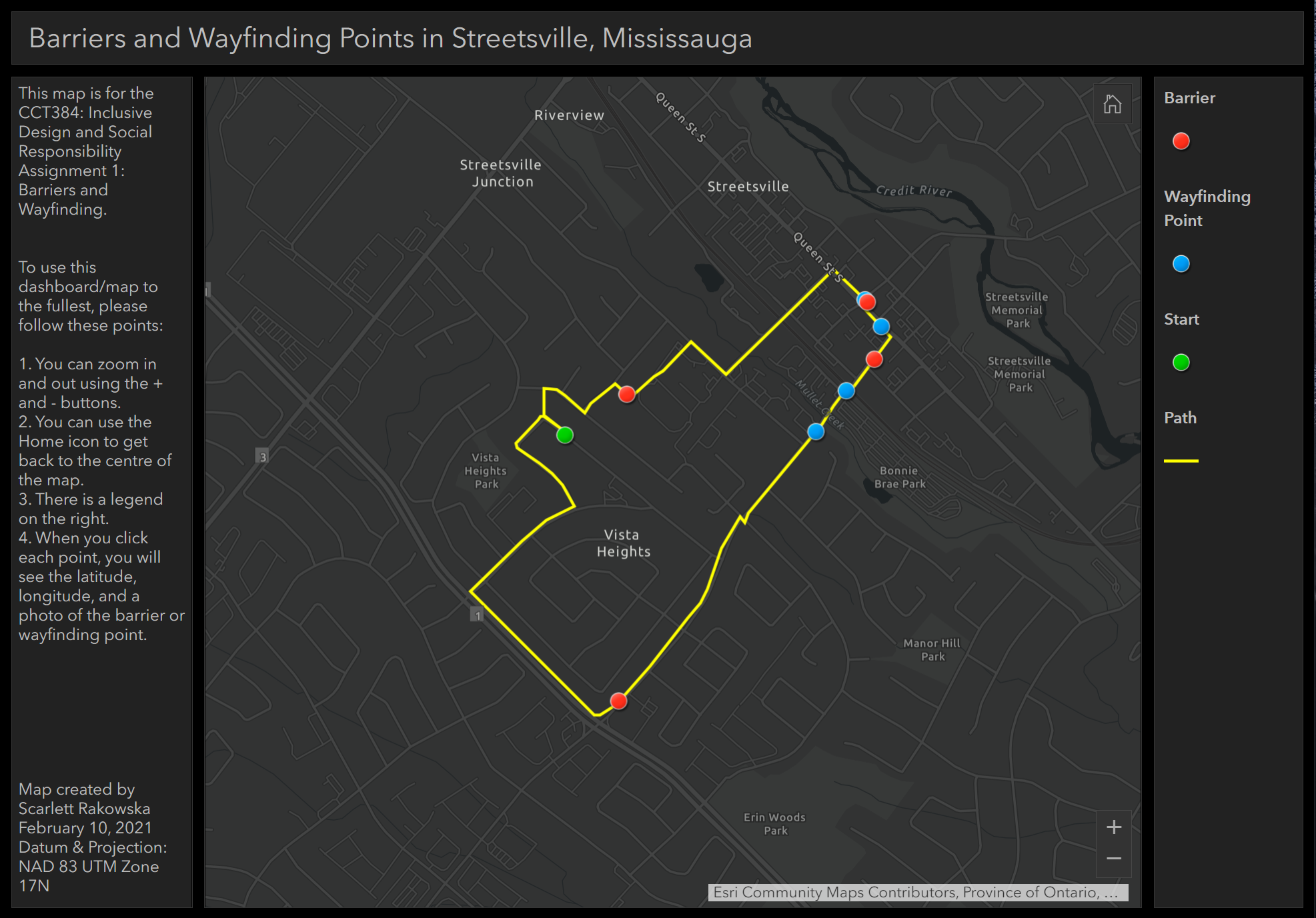 Utilizing GIS in other disciplines: Implementing photos in webmap pop-ups
Posted 4 years ago
As an undergraduate student at the University of Toronto Mississauga (UTM), I am double majoring in Geographical Information Systems (GIS) and Communication, Culture, Information, and Technology (CCIT). I am currently taking a CCIT course that involves inclusive design and social responsibility. For one of the assignments, we had to walk around our neighbourhood and take […]
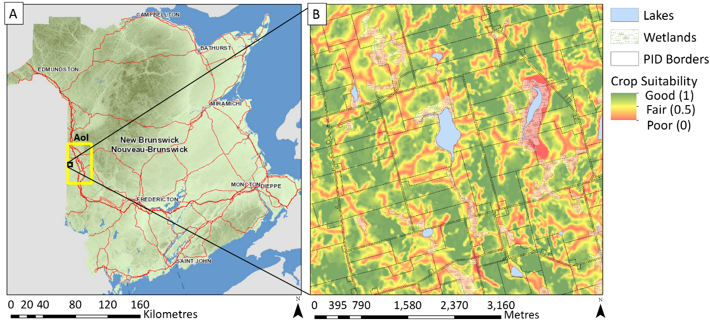 Farmland Assessment Value and Potato Crop Suitability in Carleton County, New Brunswick
Posted 4 years ago
In New Brunswick, farmlands (> 5 ha) are classified as non-residential and are assessed at market value. In contrast, freehold timberlands are assessed at one hundred dollars per hectare, while farm woodlots are assessed at one dollar per hectare [1,2]. This blog addresses the extent to which the assessed market value of farmlands reflects soil […]
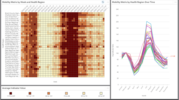 Mobility Patterns During COVID-19 with ArcGIS Insights
Posted 4 years ago
I’m sure we’re all well aware of the many impacts that COVID-19 has had on our typical lives. Working from home, attending school from home, and limits on social gatherings have significantly reduced our mobility. The Geospatial Lab at Western University has been working on a project to look at how mobility has changed over […]
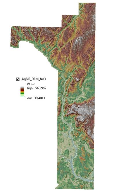 Workflow and Tools Used to Derive a Digital Elevation Model (DEM) of the “Potato Belt” Area in New Brunswick
Posted 4 years ago
I am a first-year student working towards a Master’s degree in Forestry at the University of New Brunswick (Fredericton campus). My research project is on LiDAR-based potato crop suitability mapping in the “Potato Belt” area in New Brunswick. The aim of this research is to improve New Brunswick’s food security strategy, especially in terms of expanding farming activities across forested […]