
Workflow and Tools Used to Derive a Digital Elevation Model (DEM) of the “Potato Belt” Area in New Brunswick
I am a first-year student working towards a Master’s degree in Forestry at the University of New Brunswick (Fredericton campus). My research project is on LiDAR-based potato crop suitability mapping in the “Potato Belt” area in New Brunswick. The aim of this research is to improve New Brunswick’s food security strategy, especially in terms of expanding farming activities across forested lands deemed most suitable and accessible for farming. Potato crop suitability mapping accounts for soil depth, texture, coarse fragments, density, organic matter, climate, slope, and soil drainage. The results pertaining to soil drainage, slope, growing degree days and frost-free days will be derived from the provincial LiDAR-DEM coverage using the wet-areas mapping process of the Forest Watershed Research Centre (UNB). All other soil properties will be derived from the digital version of the Forest Soil Map for New Brunswick.
I am using ArcMap to produce the above-mentioned layers. I began this project by merging individual raster datasets into a new raster dataset representing my project’s area of interest using the Mosaic To New Raster tool. Then, I used the Extract By Mask tool to extract a digital elevation model (DEM) of the area of interest from the provincial DEM dataset. From this, I created a smoothed DEM surface by using the Focal Statistics tool. Finally, I used the Hillshade tool to create a shaded relief of my DEM raster. I overlaid the DEM raster (transparency set to 45%) on top of the hillshade raster to simulate a 3D perspective.
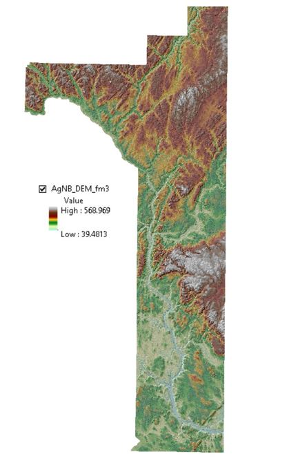
This is just a basic way of producing and visualizing a DEM. Other layers needed for my research, such as a slope raster, can now be derived from the DEM.
Next, I plan to migrate from ArcMap to ArcGIS Pro to perform subsequent geoprocessing, as it will allow me to share and consume content more efficiently. To facilitate the process, I am going to follow the Migrate from ArcMap to ArcGIS Pro lesson to gain familiarity with common tasks in the interface.