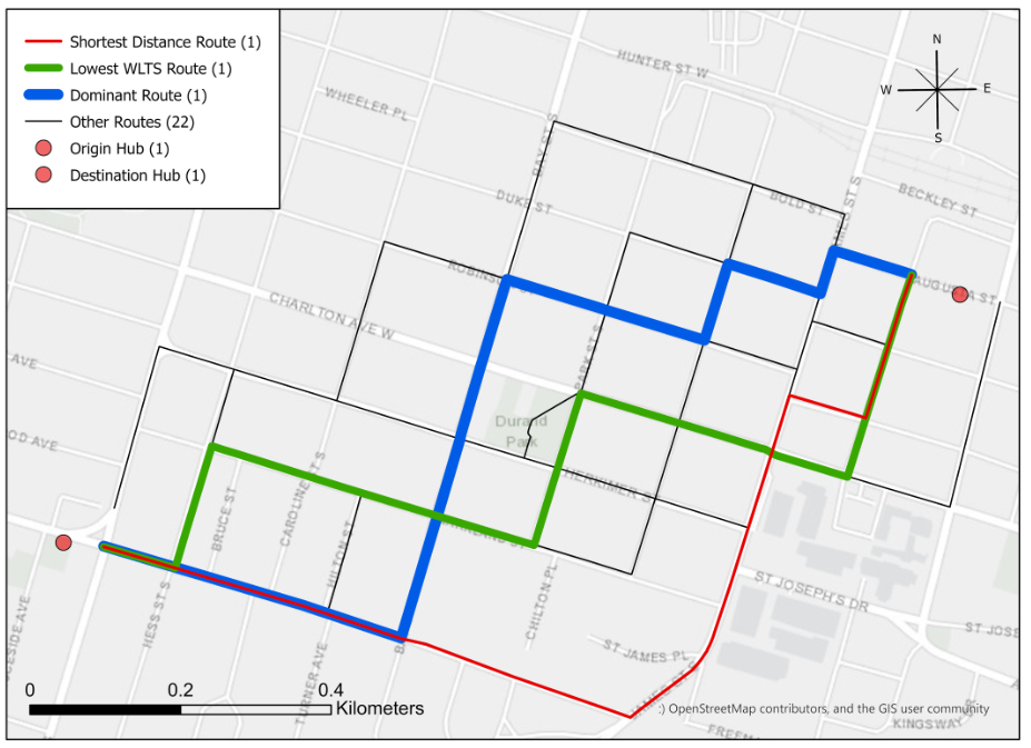
 Are Dominant Routes the Safest Routes in a Bike Share System? An Investigation of Hamilton Bike Share using Weighted Level of Traffic Stress
Posted 4 years ago
By Rajveer Ubhi
An analysis of the safety of dominant biking routes, using a level of traffic stress classification of Hamilton's cycling network.
Read More
 Developing A Level of Traffic Stress (LTS) Network using R and ArcMap
Posted 5 years ago
By Rajveer Ubhi
While cycling is a physical activity with recognized benefits, injury events do occur. Between 2006 and 2017, 890 cyclists died in Canada, averaging 74 deaths per year. Collisions with motor vehicles made up 73% of these fatal cycling events. In addition to deaths, about 7,500 cyclists were seriously injured every year during the same period […]
Read More
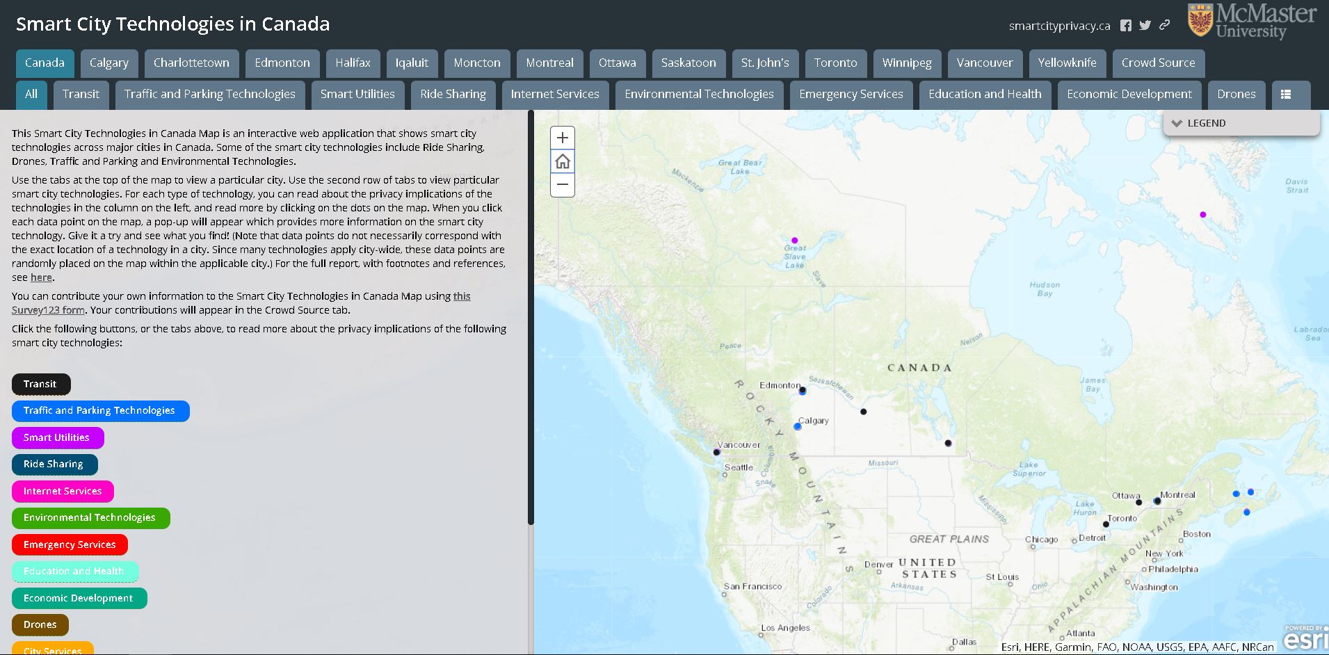 The Privacy Implications of Smart Cities: Developing a Web App and Interactive Survey
Posted 5 years ago
By Rajveer Ubhi
Smart cities, and smart technologies, are emerging in many local contexts across Canada. Smart city technologies have quickly moved from development to adoption, often outpacing the social and political deliberations necessary to consider their effects in detail-particularly their effects on the privacy of Canadians (Bannerman, 2018). Dr. Sara Bannerman and her research team at McMaster […]
Read More
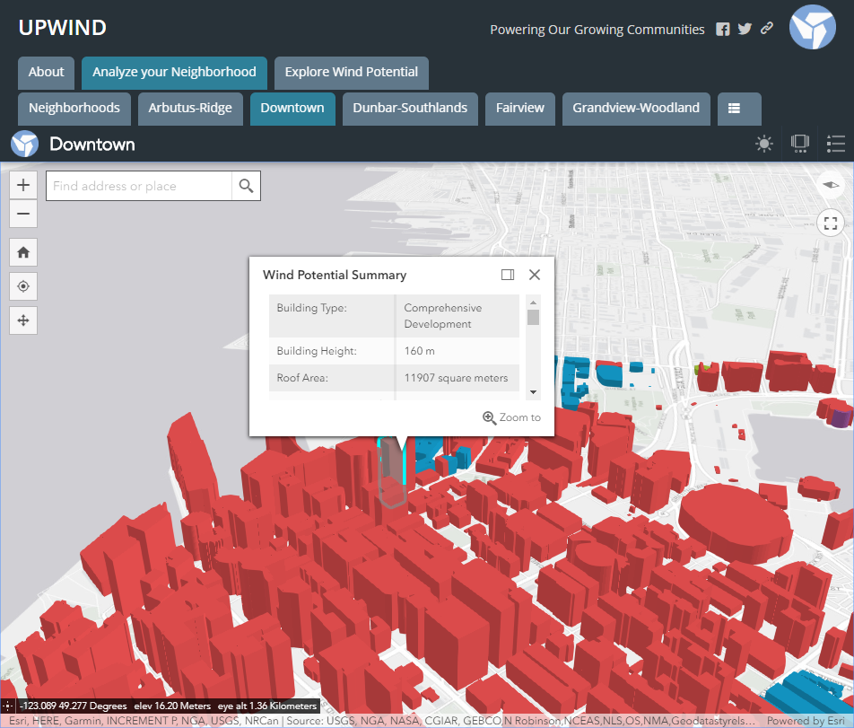 App Challenge 2019, UPWIND
Posted 5 years ago
By Rajveer Ubhi
The App Challenge project that Rajveer discusses below can be viewed from his team’s profile on the ECCE GitHub website: https://esricanada-ce.github.io/appchallenge/2019/teams/mac/McMapsters/ Introduction This year I participated in the ECCE App Challenge for the second time. My teammates included Yorgan Pitt, Edward Seh-Taylor and Sean Leipe. Our app, UPWIND, is a web application that aims to […]
Read More
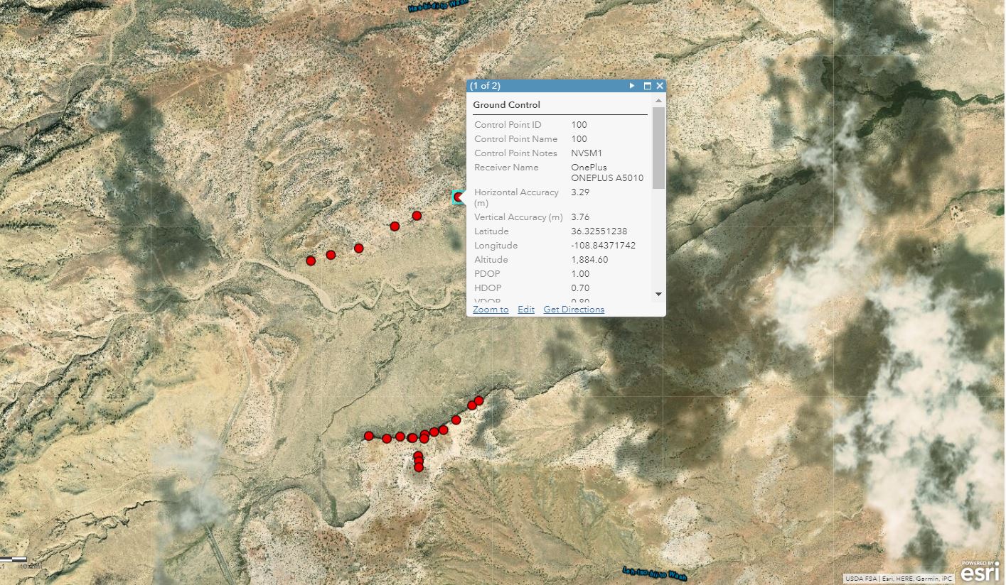 Using Mobile GIS Applications to Collect Data in New Mexico, USA
Posted 6 years ago
By Rajveer Ubhi
This year I spent most of the summer in Utah and New Mexico, USA, collecting data for my undergraduate thesis, attending conferences related to petroleum geology, and helping process the data of Master’s and PhD students part of Dr.Bhattacharya’s Quantitative Sedimentology Laboratories. My work included recording GPS coordinates of ground control points (GCPs) used for image […]
Read More
 ECCE App Challenge – DayCare Finder
Posted 6 years ago
By Rajveer Ubhi
The ECCE App Challenge is a coding competition held by Esri Canada to help promote innovation and creativity within the Centres of Excellence. Apps powered by GIS technology and open data are created to help address a problem related to a specific theme which changes every year. Being my first year participating in the challenge, […]
Read More
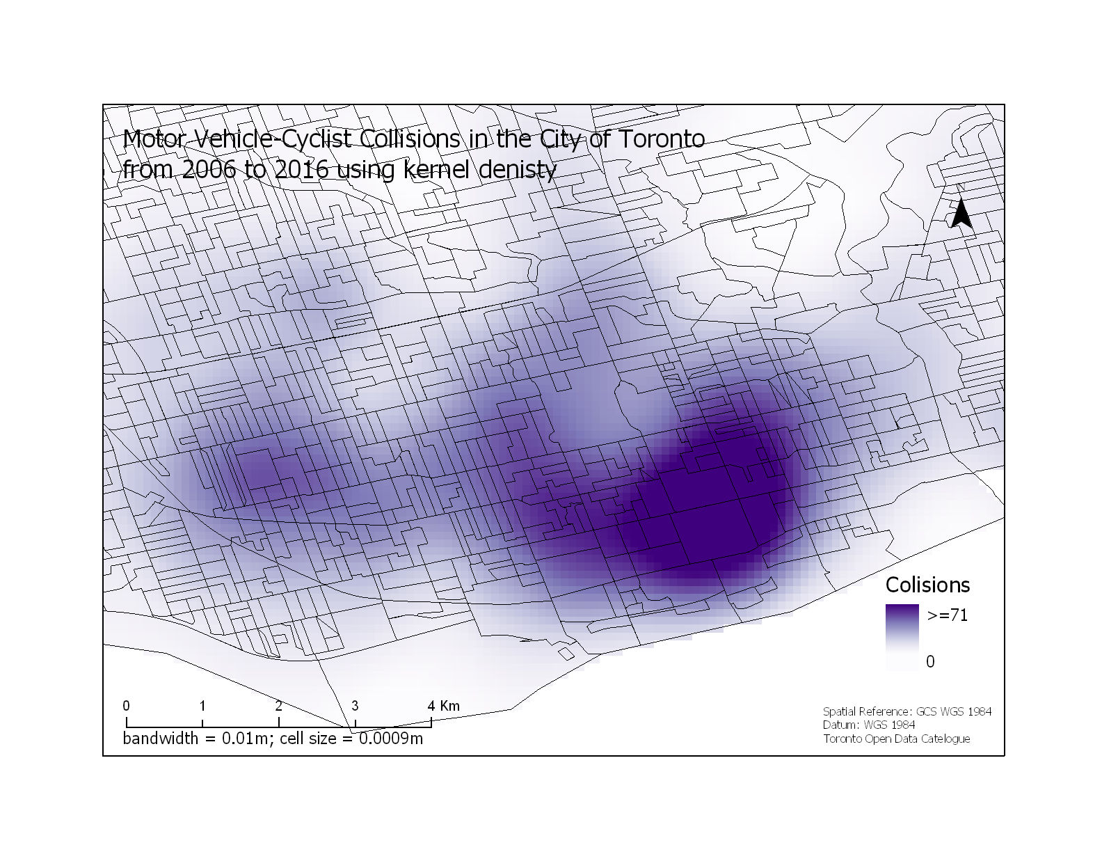 Motor Vehicle-Cyclist Collisions in the City of Toronto
Posted 6 years ago
By Rajveer Ubhi
With the gradual increase in environmental, economic and public health problems from the growing global community that uses motorized vehicles as their primary source of transportation, there has been a large interest in the use of bicycles as an alternative form of transportation. Despite the benefits of cycling, studies have shown that people are discouraged […]
Read More
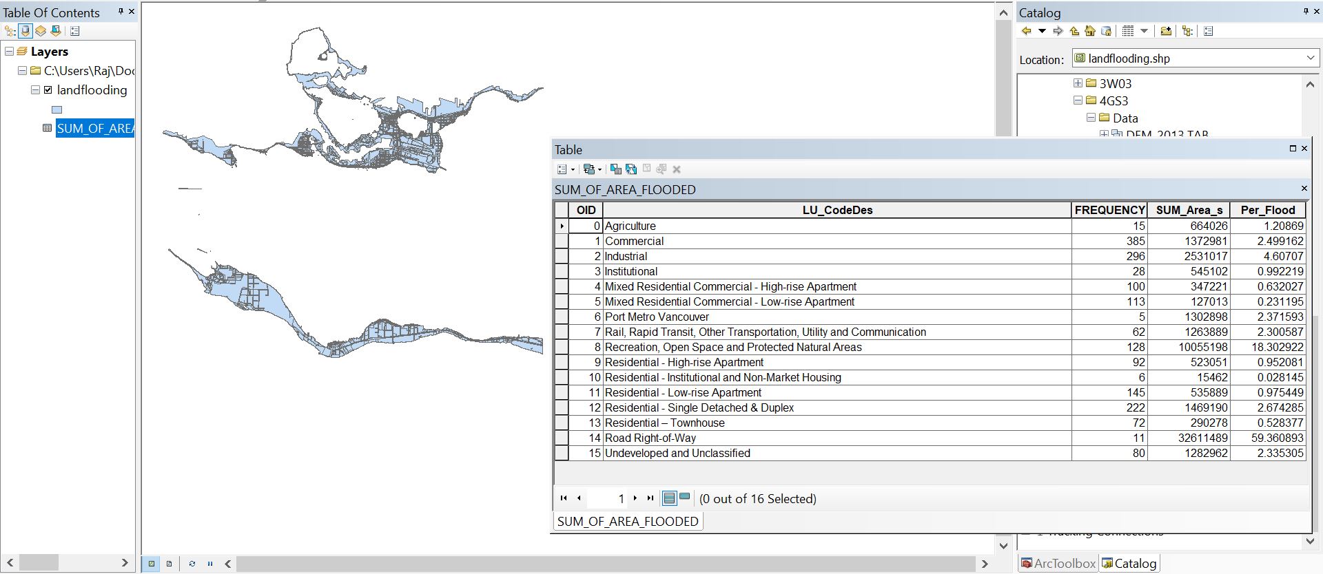 Land Flooding Tool for ArcMap generated using Python
Posted 7 years ago
By Rajveer Ubhi
This year I enrolled into GEOG 4GS3: GIS Programming offered at McMaster University. The course offers advanced treatment of GIS focusing on the creation of scripts to enhance productivity by automating time-consuming and repetitive tasks. Some of the learning outcomes include understanding the fundamental components of the Python language, developing Python scripts, working with the […]
Read More
 GIS in Education and Research and ESRI Canada User Conference: My Experience
Posted 7 years ago
By Rajveer Ubhi
A few weeks ago, I got the chance to attend the GIS in Education and Research Conference hosted at the University of Toronto. The day started off with a plenary session in the Hart House. Alex Miller, President and founder of Esri Canada, began the conference with a short talk on GIS: the science of […]
Read More

