
Is the world’s largest freshwater archipelago losing islands? How water levels impact coastal marshes
An archipelago is a collection of islands. Canada is home to 2 of the biggest, a saltwater and a freshwater archipelago. The saltwater archipelago is in the northern part of Canada (> 35 K islands) that no one during geography class was able to fully draw. It is the world’s second largest saltwater archipelago. The world’s largest freshwater archipelago (> 30 K islands) is somewhere that many may not even know about, Georgian Bay (Figure 1).
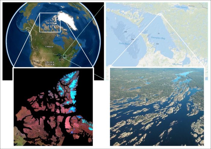
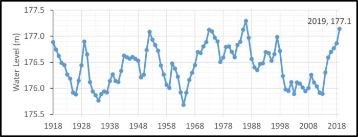
Georgian Bay is hydrologically connected to Lake Huron which is the fourth largest lake in the world by area. Its archipelago (north and eastern area), like others, are shaped by glacial retreat which creates dents and striations, forming islands, rivers, and creeks. These islands are constantly changing shape as the water levels of Lake Huron fluctuate. Water levels are affected by many “natural” or abiotic background factors, but they are also often altered by humans or beavers. The fluctuations vary from one year to another and from one minute to another. For example, in Georgian Bay, water levels from 1918 through 2019 generally vary between 175.5 to 177.5 meters above sea level (Figure 2). Periodic water level fluctuations are essential to the diversity of landscape, and impact the evolution of plants and fish in coastal marshes (Gownaris, 2018). In combination with periodic water levels and geomorphologic variabilities, coastal marshes necessitate the adaptation of organisms to new environments. Thus, stagnant water levels may decrease biodiversity and lower productivity and ecosystem services such as erosion control (Cherry, 2011). From 1999 to 2014, water levels were persistently low, whereas from 2015 onward, water levels were persistently high. Since variations in water levels, duration of relatively invariable water levels, and geomorphology (which is collectively known as hydrogeomorphology) are unpredictable to some degree and are intensified with quickly changing climates, and prompt many studies on the impacts of water levels on coastal wetlands.
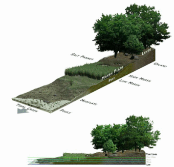
Although water levels are not currently extreme enough to remove popular islands like Beausoleil Island, rising water levels can flood land. It may seem like expanded fish habitat, but the increased volume of water does not necessarily support more fish. It is aquatic plants that provide oxygen, food, shelter, spawning, nursery, refuge, and a foraging environment (USDC, 2013). The low marsh zone supports the growth of aquatic plants whereas high marsh zones do not typically support the growth of aquatic plants. Instead it supports terrestrial plants, shrubs, and trees that may not be useful for fish (Figure 3). On the other hand, water retreating from aquatic plant zonation has the same effect, a loss of fish habitat, though it depends on the duration of water levels and plant growth. Plant zonation are of great interest to ecologist and conservationists, and since it is heavily dependent on water levels, we want to model the hydrogeomorphic change in coastal wetlands at various water levels.
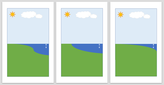
My senior independent project involved simulating changes in area and volume of coastal marshes at various water levels which would be included in an atlas for Georgian Bay. First, we decided that the water levels for simulation were 175.5, 176.0, 176.5, 177.0, and 177.5 m above sea level to have valuable comparison with a study done on the coastal marshes in the basin of Georgian Bay by Weller and Chow-Fraser (2019). The study found that at water levels of just a 0.5 m difference, the area and volume as well as zonation (> 1 m depth, > 2 m depth, etc.) varied tremendously. However, we expect that different coastal marshes are affected differently (Figure 4). Thus, my project involved studying individual coastal marshes rather than for the whole basin. During the project, I used a 10 m resolution DEM of Georgian Bay to simulate change, but we now deem it as not representative after a brief comparison with higher resolution DEMs. Changes to the methodology for calculating the area and volume includes using a higher resolution DEM and altering the outline of the marsh that accounts for rising water levels; this is part of my master’s project. Alongside my senior independent project, I created a blueprint for an atlas of coastal wetlands in Georgian Bay, under the supervision of Dr. Pat Chow-Fraser and guidance of Pat DeLuca, which helped me earn the Higher Education Scholarship in GIS. I will write a blog on our interactive atlas that uses ArcGIS Online Hub used to present, educate, and share research and GIS data acquired in the Pat Chow-Fraser Lab over the past two decades at McMaster University.
References
- Cherry, J. A. (2011). Ecology of Wetland Ecosystems: Water, Substrate, and Life. Nature Education Knowledge 3(10):16
- Gownaris, N., Rountos, K., Kaufman, L., Kolding, J., Lwiza, K., & Pikitch, E. (2018). Water level fluctuations and the ecosystem functioning of lakes. Journal of Great Lakes Research, 44(6), 1154-1163. doi:10.1016/j.jglr.2018.08.005
- US Department of Commerce, N. O. (2013, June 01). Why are aquatic plants so important? Retrieved from https://oceanservice.noaa.gov/facts/underwaterplants.html#:~:text=Underwater plants provide oxygen, food,overall ocean and estuary health.
- Weller, J. D., & Chow-Fraser, P. (2019). Simulated changes in extent of Georgian Bay low-marsh habitat under multiple lake levels. Wetlands Ecology and Management, 27(4), 483-495. doi:10.1007/s11273-019-09673-4