
Visualizing Geolocated Methane Concentration Measurements in ArcGIS Pro
Introduction
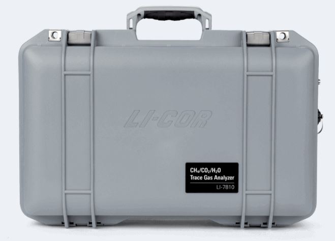
Hello! My name is Coleman Vollrath and I am a first-year MSc student at the University of Calgary in the Department of Geography. My research focuses on ways to apply new technologies, methods, and policy approaches within the upstream oil and gas (O&G) for methane (CH4) emissions compliance and reductions. This includes studying the use of human portable systems for facility screenings to detect, locate, and quantify CH4 emissions so leaks can quickly be mitigated. Currently, the technology I’m evaluating is a LI-COR CH4 sensor adapted into a human portable backpack system (Figure 1). Essentially, we attached backpack straps to the CH4 sensor and paired it with a tablet integrated with a GPS so atmospheric levels of CH4 can be geolocated at facilities for concentration mapping (CM).
Why Methane?
CH4 is an odorless, colorless, and potent greenhouse gas (GHG) that is 84x more effective at trapping heat in the atmosphere over a 20-year time period compared to carbon dioxide (CO2)[2]. CH4 emissions can come from agriculture, wetlands, waste treatment, and O&G production, but have increased rapidly in recent history as the result of anthropogenic activities[3]. In 2018, the Government of Canada released regulations to reduce CH4 emissions in the upstream O&G sector 40%-45% below 2012 levels by 2030 to satisfy international climate commitments[4]. In Canada, 44% of CH4 emissions come from the upstream O&G sector[5] which has been identified as the “low-hanging-fruit” for climate change mitigation domestically and internationally[6]. At O&G facilities, CH4 can be released into the atmosphere during routine operations that vent gas, and as fugitive (accidental) leaks from components on site that should not be emitting. Since the principal component of natural gas is CH4, it is cost-effective for O&G producers to deploy leak detection and repair (LDAR) programs that identify leaks for follow-up repair, minimizing climate impacts and the loss of a profitable resource[6].
Screening Methodology and Data Visualization in ArcGIS Pro
Currently, vehicle-based systems, which are vehicles outfitted with a GPS, anemometer, and CH4 sensor are one technology among several that are being used to identify CH4 emissions at upstream O&G facilities. Vehicle-based systems are an attractive option to use for leak detection because they require less time on site compared to traditional methods, however, they are constrained by access, terrain, and the wind direction when driving around facilities[7]. In my opinion, the human portable backpack system is a low-cost measurement technology that can overcome issues vehicle-based systems face when screening facilities for elevated CH4 emissions. So far, we have tested the backpack system by walking the fence lines at natural gas facilities, boxing-in potential emissions sources. Post-processing entails finding the difference between the peak CH4 concentrations measured at each point and background levels. Following this, the data can be easily visualized in ArcGIS Pro (Figure 2).
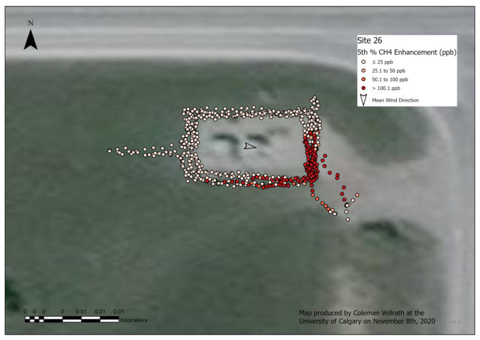
To visualize the CH4 concentration data in ArcGIS Pro as shown above, my workflow consists first of using Esri’s Table to Point tool to bring in the geolocated CH4 measurements after establishing a folder connection. This creates a CM of points on top of the base map. However, all of the points initially look identical because of the default symbology. Since we are interested in the changes (or lack thereof) in CH4 concentrations above background atmospheric levels around facilities, it’s necessary to change the symbology of the points before engaging further in geospatial analysis. Personally, I think an excellent way to visualize concentration measurements in ArcGIS Pro is by using a graduated color scheme and setting manual data intervals that can be used across all sites. For example, we surveyed 33 facilities of the same sub-type, and having symbology and a legend that is consistent for the CM of each facility is critical for proper interpretation by the map-user even if CH4 levels differ between sites.
In Figure 2, it the data are binned into four manually defined intervals, which are visualized with a 4-class red color scheme. This is an effective way at presenting these CH4 concentration data because it accurately represents ambient levels and elevated levels that would indicate a leak. Harnessing the symbology capabilities within ArcGIS Pro is something that takes time to achieve the best communication of the data possible. In one of my classes this semester, Geography 567: Programming in GIS, I have learned how to use Python within ArcGIS Pro to facilitate faster data processing. Here, I used the Python window in ArcGIS Pro to run some simple code using the Apply Symbology From Layer function in the Data Management toolbox, an example of which is displayed below.
import arcpy
arcpy.ApplySymbologyFromLayer_management("Site 26", "Site 1")
This applied the symbology presented in Figure 2 at Site 26 to Site 1. The same code was run to achieve a consistent symbology at other facilities as needed, which saved me significant amounts of time when creating these CM maps. This is important, especially given the fact that the turn-around time for data analysis needs to be fast, so that a CH4 leak can be identified and addressed as soon as possible. An example of this code can also be found in Esri’s Tool Reference section on their website, and I encourage anyone that is new to coding to consult the wealth of programming information Esri makes available to the public to speed up their workflows. A loop structure in the code above would have enabled even quicker processing, but since I am still actively learning code, I decided to keep it simple. I look forward to following up on the progress I make using Python in ArcGIS Pro for CH4 concentration data visualization in my next blog post!
References
- LI-COR. (2020). LI-7810 Trace Gas Analyzer. https://www.licor.com/env/products/trace_gas/LI-7810
- Myhre, G., D. Shindell, F.-M. Bréon, W. Collins, J. Fuglestvedt, J. Huang, D. Koch, J.-F. Lamarque, D. Lee, B. Mendoza, T. Nakajima, A. Robock, G. Stephens, T. Takemura & H. Zhang. (2013). Anthropogenic and Natural Radiative Forcing. In: Climate Change 2013: The Physical Science Basis. Contribution of Working Group I to the Fifth Assessment Report of the Intergovernmental Panel on Climate Change. Cambridge University Press, Cambridge, United Kingdom and New York, NY, USA.
- Maazallahi, H., Fernandez, J. M., Menoud, M., Zavala-Araiza, D., Weller, Z. D., Schwietzke, S., … & Röckmann, T. (2020). Methane mapping, emission quantification and attribution in two European cities; Utrecht, NL and Hamburg, DE. Atmospheric Chemistry and Physics Discussions, 1-30.
- Government of Canada (2019, April 1). About methane emissions. https://www.canada.ca/en/environment-climate-change/services/climate-change/global-methane-initiative/about-methane-emissions.html
- Government of Canada (2018, April 26). Canada’s methane regulations for the upstream oil and gas sector. https://www.canada.ca/en/environment-climate-change/services/canadian-environmental-protection-act-registry/proposed-methane-regulations-additional-information.html
- IEA (2020). Methane Tracker. https://www.iea.org/reports/methane-tracker-2020
- Fox, T. A., Barchyn, T. E., Risk, D., Ravikumar, A. P., & Hugenholtz, C. H. (2019). A review of close-range and screening technologies for mitigating fugitive methane emissions in upstream oil and gas. Environmental Research Letters, 14(5), 053002.