
NSCC Campus Crawl – A Nova Scotia Route Optimization Guide
In one of our Location Analytics course projects, we are asked to utilize ArcGIS Pro Network Analyst extension to identify optimal routes for subjects of our interest. Travelling has always been my passion, but logistics planning can be tricky: within a limited timeframe, how can one maximize their travel footprint? Given the landscape and infrastructure of Nova Scotia, I am interested in exploring an optimized route to tour the province. While the stopping point locations are highly subjective, for this project, I opted to use the 14 campuses of Nova Scotia Community College (NSCC) and Halifax Stanfield International Airport (YHZ) as the stopping points since the campus locations are well-distributed across the province, and the airport is the main transportation hub for out-of-province travelers. The project output can be easily revamped for prospective students, faculty, funders, and industry partners as open house or trade show route planning.
Network Analyst & Data Preparation
ArcGIS Network Analyst extension utilizes road network architecture to enable effective transportation planning and location analytics. In ArcGIS Pro, a network data source is required prior to performing network analyses, either from locally stored geodatabase or from an active portal via URL. ArcGIS Online portal was set as the network data source for this project, which will consume credits when running the analyses. It is also possible to create a network dataset with your own or open-sourced data, visit this page to learn more.
As demonstrated in my previous blog post, the ArcGIS Business Analyst extension provides a convenient ‘Business and Facilities Search’ function, where I was able to generate a point layer for NSCC campuses with minor adjustments to update incorrect or missing locations. Point for YHZ was then manually created and added to the same layer twice as start and end point.
Route Network Analysis
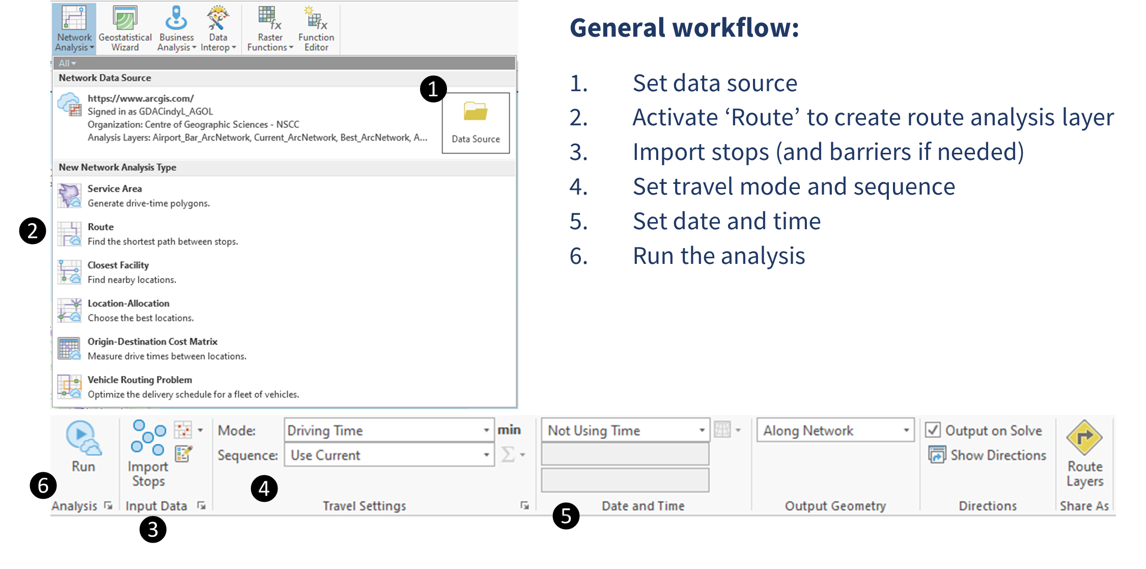
Several route analyses were conducted using different scenarios, which were set in the Network Analyst’s Route toolbar (see image above, step 4 & 5 in general workflow).
- Default ‘Use Current’ travel settings and no date/time setting
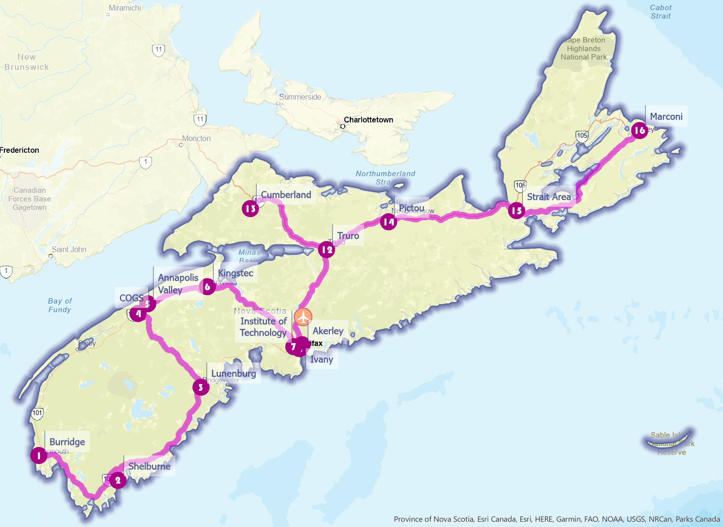
- ‘Find Best’ sequence based on travel condition on Mondays at 10 AM
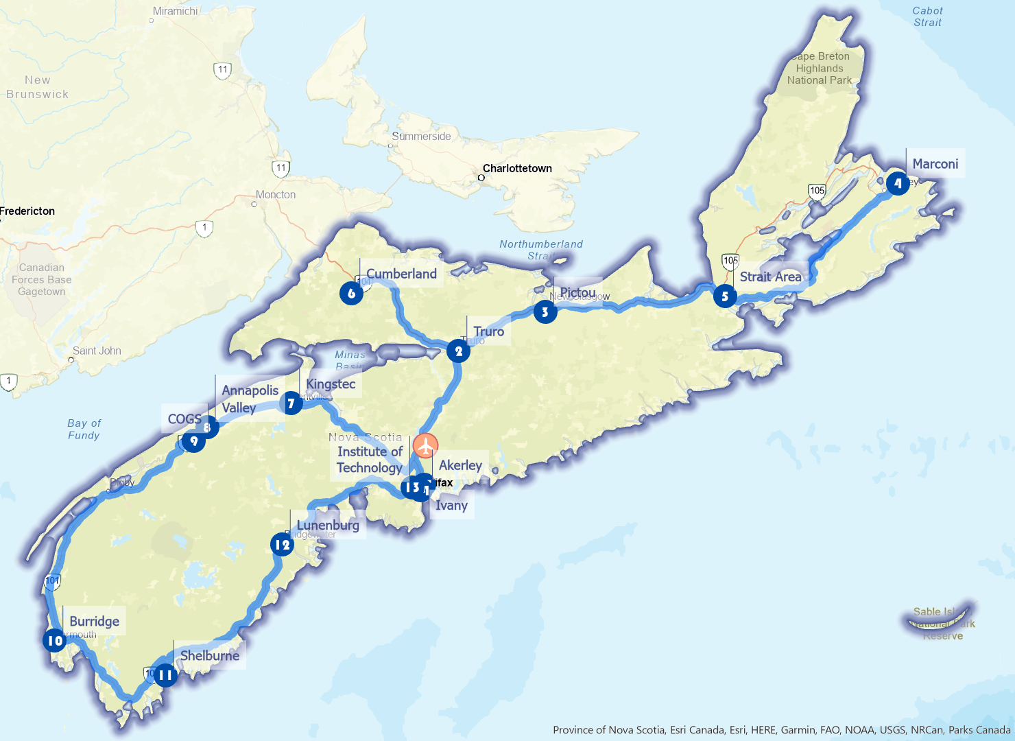
- YHZ as first and last stop and based on travel condition on Mondays at 10 AM
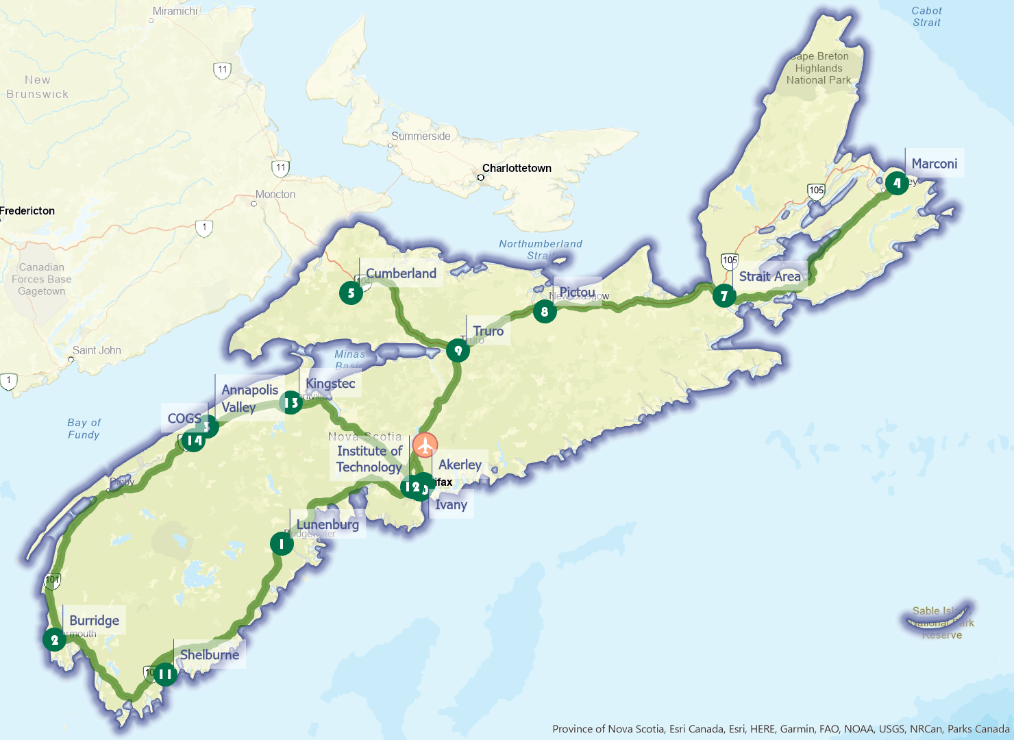
Note that the route footprint looks identical for scenario 1 and 3, which follows major Nova Scotia highway system. Scenario 1 preserves the stopping point sequences when the points were imported, and does not reflect any spatial relationship between the points (for example, does it make sense to visit Shelbourne Campus as the 11th stop when it is located between the first and second stop?). From the route attribute table, we can see that this route is 2800.37 km long and will take around 1813 minutes (or just over 30 hours) to complete with non-stop driving.
Scenario 2 calculates a one-way optimal route and determines the Burridge Campus in Yarmouth as the best start point, and the Marconi Campus in Sydney as the end point. Although the assumption for this project was to start and end the trip in YHZ (the 10th and 11th stop in this scenario), this route can be achieved realistically depending on where the travelers are based in, considering both Yarmouth and Sydney are equipped with an airport and a ferry terminal. This route is 1082.27 km long and will take just under 13 hours to complete. An extend trip to Newfoundland and Labrador with the extra time saved perhaps?
Going back to our assumption of starting and ending the trip in YHZ, scenario 3 provides a solution to first travel towards Cape Breton, make a detour in Cumberland before travelling around the Bay of Fundy and Acadian Shores, and finally reach Halifax Metro via the South Shore. Seems like an interesting and effective route that allow travelers to experience the diverse landscape of Nova Scotia! This route is 1641.97 km long and will take around 18 hours to complete.
Barriers
When solving the optimal route, the Network Analyst’s Route tool can also take barriers that potentially cause restrictions or delays into consideration. Based on Nova Scotia’s Highway Construction Project list and the Nova Scotia Road Network data, a line layer highlighting 3 construction sections was generated, and imported as Line Barriers before running the Route tool. Travel settings were kept the same as in scenario 3 above.
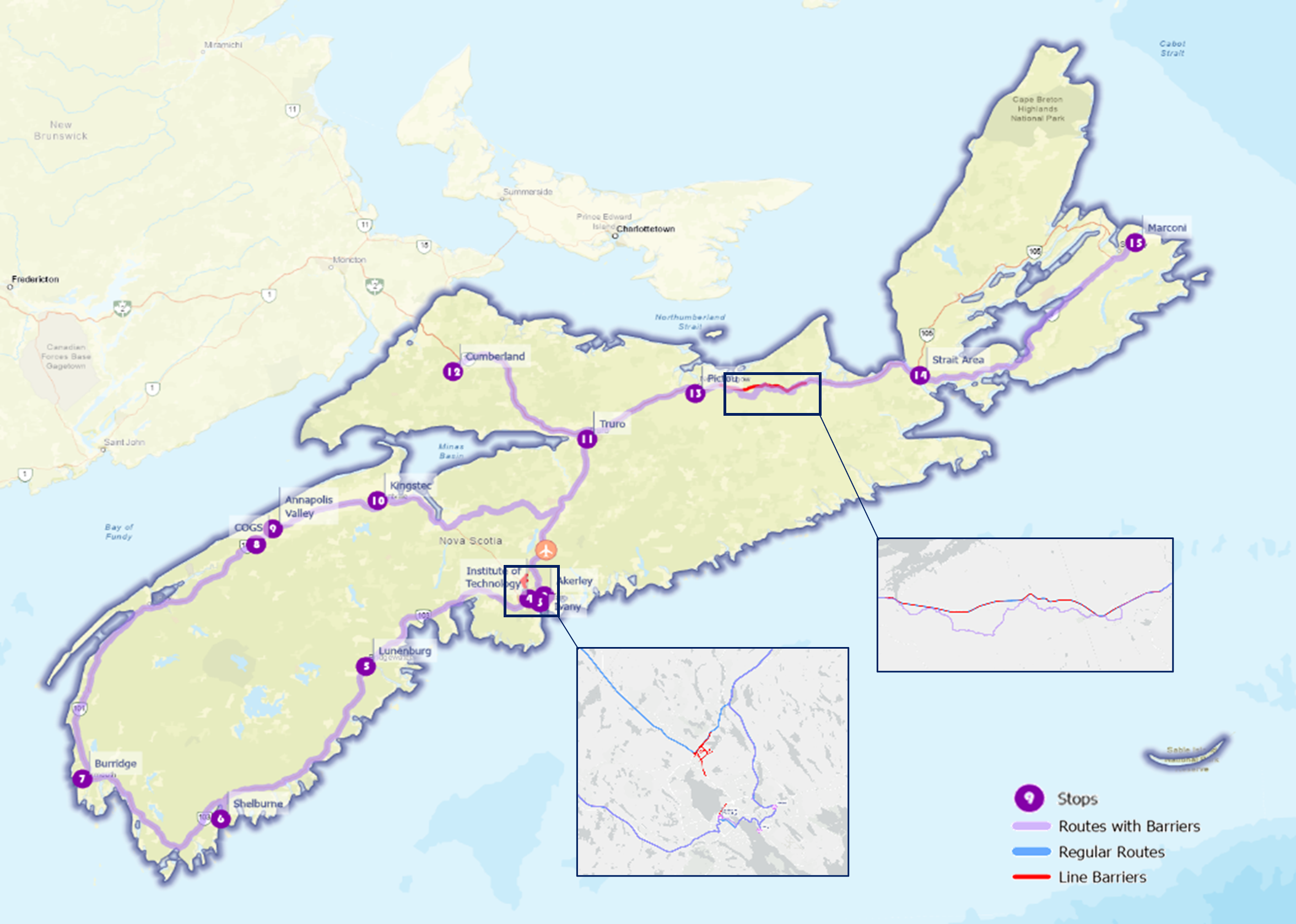
The analysis produces a revised route avoiding the construction areas. Note that the new route suggests an opposite travel direction from that in scenario 3, starting the trip in the Halifax and South Shore regions and ending in Cape Breton before returning to YHZ. The route length is 1639.52 km and will take 19 hours to complete. In this scenario, avoiding road constructions will add an extra hour, but the route length is actually slightly shorter than that without the barrier restriction.
Summary
This project demonstrates the application of ArcGIS Pro Network Analyst extension in route optimization. By experimenting with different travel and barrier settings, the results can be different. As the route planner, it is important to consider the needs and goals of the route. Would you prioritize travel time over travel distance, or vice versa? In the tourism context, the stopping points can be easily replaced with tourist attractions, wineries, lighthouses, etc. The tool can also be applied in a more localized scale, such as determining an effective courier delivery route (Network Analyst actually has specialized Vehicle Routing Problem tools for these applications).
Do you have a route planning project in mind? Comment below and share how you would conduct a network analysis.