
Mapping Cultural Character
As a second year Masters of Geographic Information Systems (GIS) student at the University of Calgary, I have applied Esri software to a wide variety of topics and problems, often to areas not traditionally thought of as applicable to GIS. This past summer, I had the opportunity to see how GIS and sociology can come together to relay the cultural significance of an area – this is where my passion for GIS stems from, and although it is a lesser known field of study, it is immensely applicable and relevant.
The Chinatown in Calgary is a unique neighborhood that is cherished by many people (Patterson et al., 2019). The City of Calgary is currently creating a community development plan for this area and, after initial consultations, has recognized a need to incorporate culture into the planning process (Patterson et al., 2019). Community members revealed that culture, heritage, and language preservation were among the most important issues facing the community (Patterson et al., 2019). What distinguishes the culture of one neighborhood from another can be challenging to communicate. As noted in the Identity and Culture in Chinatown report (Patterson et al., 2019), the City of Calgary defines culture as:
“…anything that defines the unique identity of a community or social group. Those characteristics often include social customs, seasonal traditions, geography, cuisine, oral traditions, fashion, literature, music and religious expression. However, culture also includes less obvious aspects of our lives such as heritage (both built and natural), community initiatives and the creative economy, which can include film & video industries, advertising, design & fabrication, performing arts and much more.” (MDB Insight, 2016, p. 3)
Our research team used a GIS to map the location of buildings, storefronts, community associations, and cultural landmarks within Chinatown as part of the Identity and Culture in Calgary’s Chinatown report. This report is intended to inform the broader cultural planning process that will take place by further consulting members of Chinatown and the public (Patterson et al., 2019).
Mapping important aspects of Chinatown allows for a visual representation of this neighborhood. It can help convey the sense of meaning that this place holds to those who live in and visit the area that may not otherwise be possible to document with words and images alone. GIS also serves as a mechanism to store and present data regarding features of the built environment. For example, we were able to store whether the aesthetic of signage in Chinatown was English, Chinese, or both, whether a store front was welcoming or hostile, and whether it was ground floor or above ground floor. This is important because many above ground floor storefronts in Chinatown are community institutions not typically known to non-Chinese Calgarians or tourists. However, these institutions play a significant role in building a sense of community among residents and other Chinese-Canadians (Patterson et al., 2019). Mapping them helps ensure these areas are considered in cultural development planning. We used ArcGIS Pro to merge our datasets with additional data provided by the City of Calgary and to clean up any errors in the collected data.
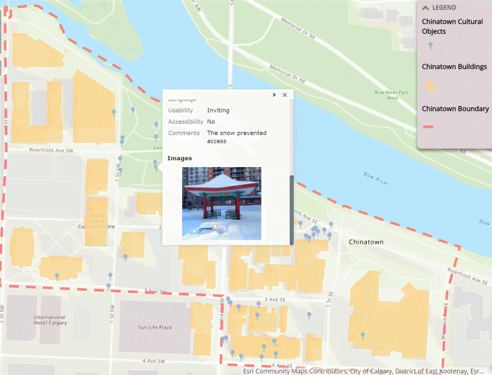
These final datasets were then used to create different web-based maps of Chinatown using Esri’s Story Map Web Application (Figure 1). Esri’s web applications allow an intuitive way for users to interact more completely with datasets. Being a larger dataset, it is not feasible to visualize all the features and details of Calgary’s Chinatown in a single map at once. Webmaps allow for various different views of the data. The user may interact with the map by clicking on data points to receive more information. For example, users of our maps can click on a cultural object and see the real life image of the feature (Figure 2). Click here to access the full story map: Calgary Chinatown Cultural Character

In the future, we would like to build more sophisticated web maps and applications, allowing users to query various features of the map. For example, how many of the cultural objects in Chinatown have Chinese/Asian aesthetic and where are they located on the map? Or, how many of the buildings are considered residential?
References Cited
MDBInsight. 2016. Culture Plan for Calgary. Calgary: City of Calgary.
Patterson, Matt, Lindsey Kokaritis, Jacey Magnussen, and Jason Yip 2019. Culture and Identity in Calgary’s Chinatown. Unpublished Manuscript.