
Unlocking the secrets of glacial retreat using remote sensing: Peru’s Cordillera Blanca
Hi everyone! My name is Henry Gage and I am a fourth year undergraduate student in McMaster’s Integrated Science program. I work in the McMaster Glacial Sedimentology lab, where I study the retreat of tropical glaciers. This summer I had the opportunity to travel to Peru to combine UAV and satellite remote sensing with paleoclimatic sediment data.
The Cordillera Blanca, situated in the Peruvian Andes, is the most glaciated area in the Tropics. Tropical glaciers are particularly sensitive to climate change because they are small, with steep mass balance (gain versus loss of ice) gradients (Kaser and Osmaston, 2002; Kaser et al., 2003). In the last century, glacial extent in the region has decreased by approximately 400km2—nearly half of the total glaciated area (Baraer et al., 2015; Silverio and Jaquet, 2017). This is concerning because over 1 million people rely solely on glacial meltwater for their freshwater supply (Bury et al., 2011). My research explores changes in water quantity and quality resulting from glacial retreat in Lake Shallap, a small proglacial lake fed by a retreating valley glacier, where I seek to answer the following:
What are the implications of contemporary climate change for glacial meltwater quality and quantity in the Cordillera Blanca?
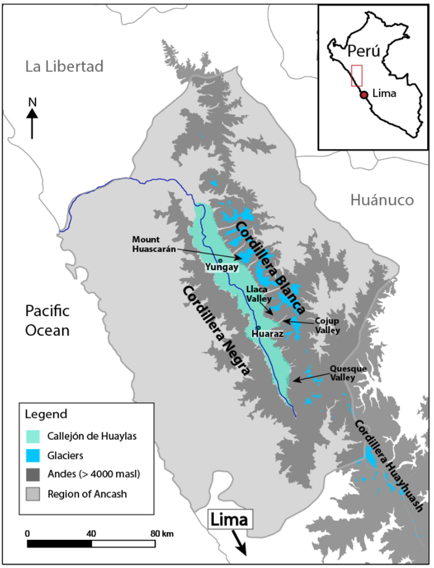
Location of the Cordillera Blanca, a glaciated area of the Andes in Peru (Narro Perez, 2021).
Glaciology research on climate change often focuses on long-term trends, because glaciers extend and retreat over geological timescales (thousands to millions of years). In the Cordillera Blanca, many authors have examined these long-term trends (e.g., Glasser et al., 2009; Stansell et al., 2013; 2017), yet few have examined how anthropogenic climate change has impacted glaciers over the past century. For this reason, we examined short-term paleoclimatic data in sediment cores extracted from Lake Shallap, which provide records over the past 100 years. Using geochemistry techniques, we observed a steady rise in sediment input, iron, and sulfur in the lake over the last century, all of which show nearly identical trends. In the 1980s, there was an abrupt change—suddenly, these geochemical proxies increased rapidly in magnitude and variability. While paleoclimatic records provide information about what occurred in the past, they do not allow us to observe the processes responsible for these changes. Why did sediment input, iron, and sulfur abruptly rise? Why would sediment input be correlated with iron and sulfur deposition?
Remote sensing is a powerful tool when combined with paleoclimatic data, because it enables us to connect past and contemporary processes. This provides insight into the ‘why’ and ‘how’, expanding our ability to interpret the trends we observed in the lake sediment. Using multispectral Sentinel-2A imagery, we measured glacial extent using the Normalized Difference Snow Index and the relative abundance of ferrous iron (Fe2+), an ion uniquely produced by weathering of bedrock, using the Ferrous Iron Index. This revealed that glacial extent and iron enrichment are spatially associated. Areas of high glacial retreat are enriched in Fe2+, whereas those with little retreat or a gain in glacial ice have a lower relative abundance of iron. Moreover, we found that iron enrichment occurs near the glacier terminus and within the proglacial valley, both areas where ice has uncovered bedrock.
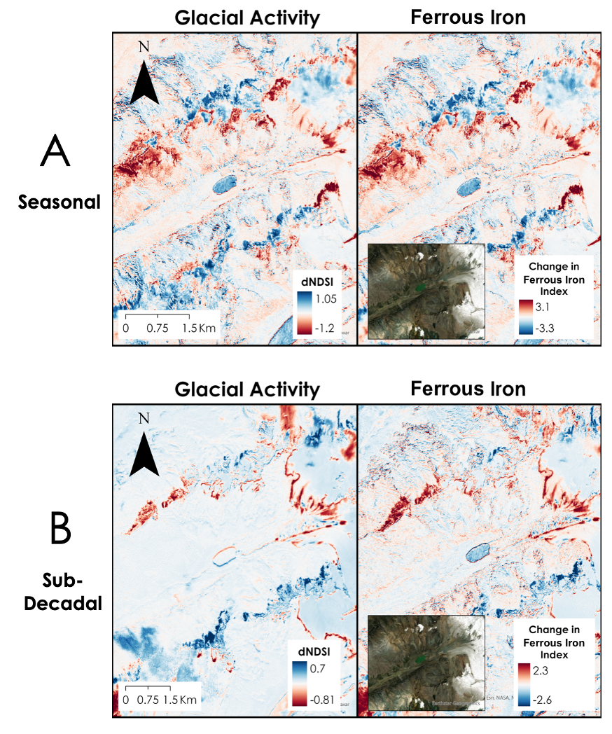
Changes in glacial extent (left) and iron enrichment (right) over a five-year period between 2017 and 2022 in the Shallap Valley, Peru. On the left, red indicates areas of glacial retreat, while blue indicates an increase in glacial extent; on the right, red indicates an increase in the relative abundance of ferrous iron, and blue indicates a decrease.
When paired with drone imagery, this suggests that glacial retreat drives iron enrichment. Our drone surveys of valleys in the Cordillera Blanca show that areas recently uncovered by the Andes’ retreating glaciers are orange-brown and iron-rich, with exposed bedrock (see below). Meltwater streams, such as that shown in the image below, leave orange deposits of iron sourced from the bedrock. Together, the paleoclimatic and remote sensing data indicate that, as glaciers in the Cordillera retreat, the bedrock they expose is weathered, which converts minerals such as pyrite (FeS2) into a variety of iron compounds and other ions. The intensification of warming in the 1980s drove an exponential rate of glacial retreat, which was associated with a rapid increase in iron.
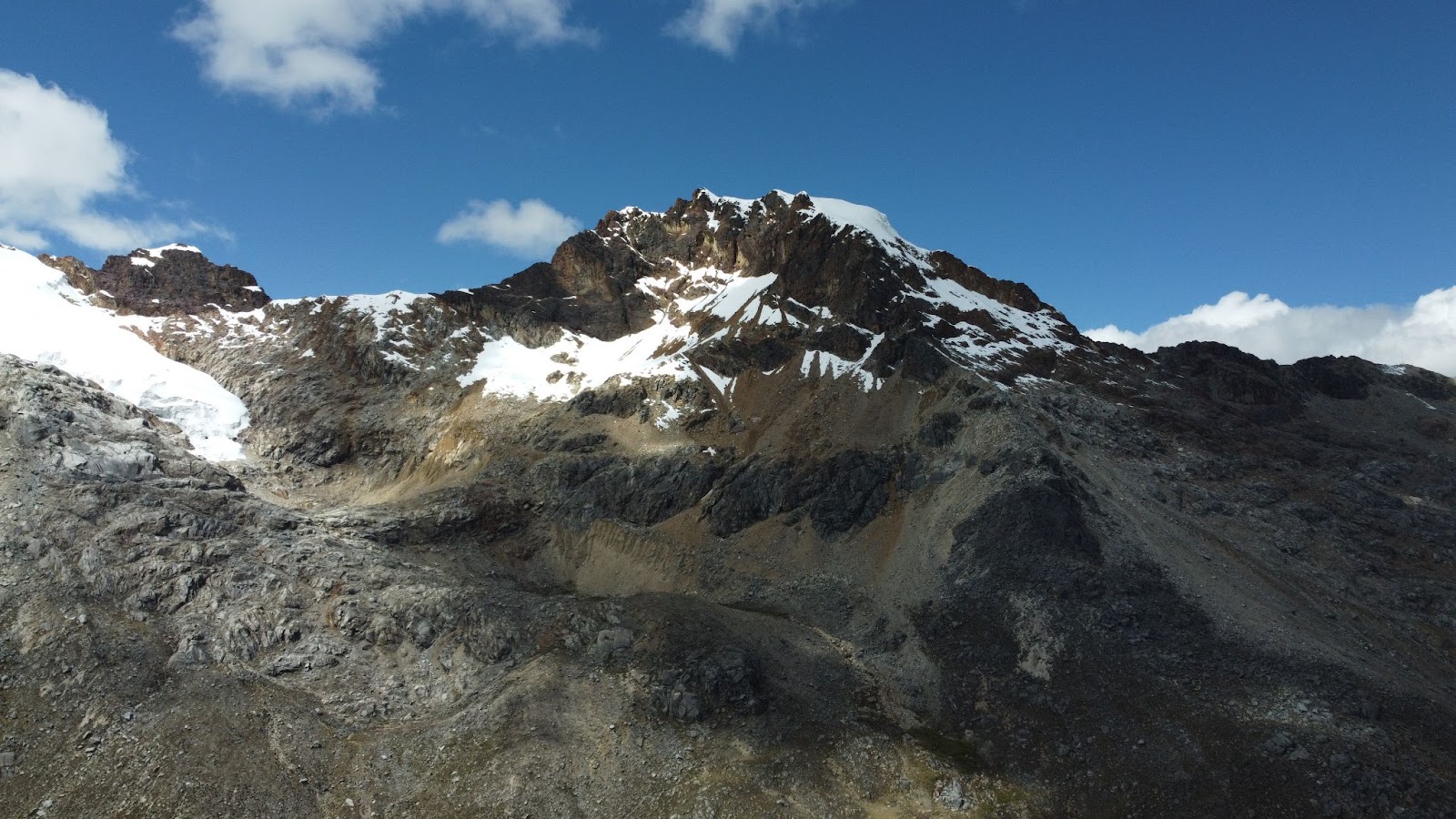
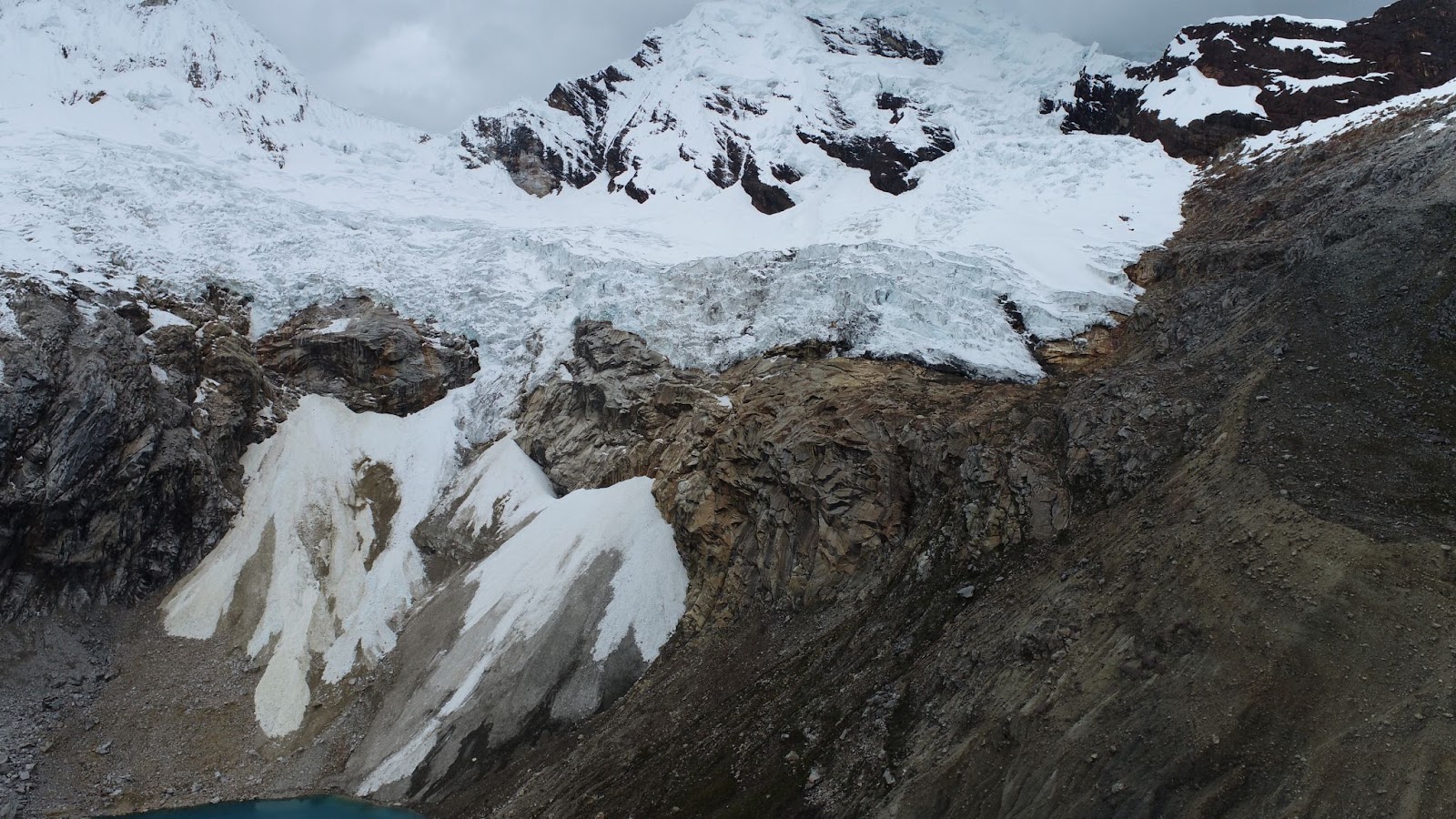
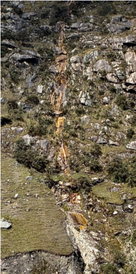
Drone imagery obtained in May, 2022 of proglacial valleys in the Cordillera Blanca illustrating iron enrichment in recently deglaciated areas (top, middle) and along meltwater streams (bottom).
This is concerning, because many of the products of these bedrock weathering reactions are toxic, which collect in the glacial meltwater and contaminate the region’s proglacial lakes. For the local population, this poses a significant threat because they rely solely on Andean glaciers for freshwater. To better understand the rate, implications, and processes responsible for water contamination in Peru’s Cordillera Blanca, our laboratory (and others) are expanding the use of remote sensing, employing drones to take high-resolution multispectral imagery and produce photogrammetric models to represent glacial landforms. We are fortunate to collaborate with INAIGEM, a Peruvian government organization responsible for overseeing research on glaciers and mountain ecosystems, to continue exploring the implications of climate change on Tropical glaciers.
Works Cited
Baraer, M., McKenzie, J., Mark, B.G., Gordon, R., Bury, J., Condom, T., Gomez, J., Knox, S. and Fortner, S.K., 2015. Contribution of groundwater to the outflow from ungauged glacierized catchments: a multi-site study in the tropical Cordillera Blanca, Peru: CONTRIBUTION OF GROUNDWATER TO GLACIERIZED CATCHMENTS IN C.B., PERU. Hydrological Processes, 29(11), pp.2561–2581. https://doi.org/10.1002/hyp.10386.
Bury, J.T., Mark, B.G., McKenzie, J.M., French, A., Baraer, M., Huh, K.I., Zapata Luyo, M.A. and Gómez López, R.J., 2011. Glacier recession and human vulnerability in the Yanamarey watershed of the Cordillera Blanca, Peru. Climatic Change, 105(1–2), pp.179–206. https://doi.org/10.1007/s10584-010-9870-1.
Glasser, N.F., Clemmens, S., Schnabel, C., Fenton, C.R. and McHargue, L., 2009. Tropical glacier fluctuations in the Cordillera Blanca, Peru between 12.5 and 7.6ka from cosmogenic 10Be dating. Quaternary Science Reviews, 28(27), pp.3448–3458. https://doi.org/10.1016/j.quascirev.2009.10.006.
Kaser, G., Juen, I., Georges, C., Gómez, J. and Tamayo, W., 2003. The impact of glaciers on the runoff and the reconstruction of mass balance history from hydrological data in the tropical Cordillera Blanca, Perú. Journal of Hydrology, 282(1), pp.130–144. https://doi.org/10.1016/S0022-1694(03)00259-2.
Kaser, G. and Osmaston, H., 2002. Tropical Glaciers. Cambridge University Press.
Silverio, W. and Jaquet, J.-M., 2017. Evaluating glacier fluctuations in Cordillera Blanca (Peru) by remote sensing between 1987 & 2016 in the context of ENSO. Archives des Sciences, 69, pp.145–161.
Stansell, N.D., Licciardi, J.M., Rodbell, D.T. and Mark, B.G., 2017. Tropical ocean-atmospheric forcing of Late Glacial and Holocene glacier fluctuations in the Cordillera Blanca, Peru. Geophysical Research Letters, 44(9), pp.4176–4185. https://doi.org/10.1002/2016GL072408.
Stansell, N.D., Rodbell, D.T., Abbott, M.B. and Mark, B.G., 2013. Proglacial lake sediment records of Holocene climate change in the western Cordillera of Peru. Quaternary Science Reviews, 70, pp.1–14. https://doi.org/10.1016/j.quascirev.2013.03.003.