
Where is the Carbon? Spatially mapping carbon on the seafloor
Hi everyone! My name is Catherine Brenan and I am an undergraduate student completing a combined honours in Environmental Science and Chemistry with a certificate in GIS at Dalhousie University. I am doing my research in the Oceanography department, specifically examining how to spatially map carbon on the seafloor in the Eastern Shore Islands.
Background
Coastal sediments are some of the largest stocks of organic carbon and play a vital role in influencing the carbon cycle. Once buried, organic carbon can stay on the seafloor for thousands to millions of years (Estes et al., 2019). Protecting organic carbon hotspots is essential to mitigating climate change since coastal development and bottom trawling can disturb the seafloor, leading to the remineralization of organic carbon into carbon dioxide (Paradis et al., 2021).
Much research has been done to spatially map terrestrial carbon stocks (Asner et al., 2011, 2012), but there has been a lack of mapping of sedimentary carbon and insufficient appreciation of the role that it can play in minimizing the effects of climate change (C. A. Hunt et al., 2021). When determining marine carbon stocks, researchers have previously used non-spatially explicit estimates of carbon by multiplying the average carbon density of marine sediments by their global extent (Emerson & Hedges, 1988). This approach increased uncertainty and limited our understanding of the biogeochemical processes and human impacts that influence carbon stocks (Atwood et al., 2020). Other studies on carbon stocks focused on vegetated coastal ecosystems such as mangroves (Sanders et al., 2016), seagrasses (Fourqurean et al., 2012), and salt marshes (Osland et al., 2018). While these studies have advanced our knowledge of the carbon cycle, we still have a limited understanding of the spatial distribution of organic carbon on the heterogenous seabed (Smeaton & Austin, 2019).
Multibeam Echosounder Surveys
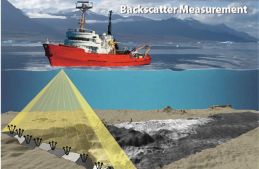
Recent advancements in multibeam-echosounder surveys (MBES) have led to the ability to create spatially continuous high-resolution carbon maps. MBES provides information about the composition of the seafloor, such as the morphology, hardness, sediment characteristics, and sediment grain size. MBES can also collect both bathymetry and backscatter data at the same time. Bathymetry is the delay between emission of the pulse and receipt of the returned signal, which provides a depth measurement (Smeaton & Austin, 2019), while backscatter is determined by the strength of the returned signal indicating the reflectivity of the seafloor (Figure 1&2).
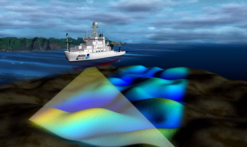
Backscatter can be essential for classifying sediment types since a hard/rough seabed with coarse sediments scatters the acoustic signal in all directions, whereas soft/smooth surface comprising fine sediments produces less scattering, resulting in a maximum backscatter intensity (BWSG_REPORT_MAY2015_web.Pdf, 2015). Additionally, backscatter is essential to mapping organic carbon since there is an empirical relationship between sediment grain size, organic carbon and between sedimentary properties and backscatter reflectance (C. Hunt et al., 2020; C. A. Hunt et al., 2021; Smeaton et al., 2021; Smeaton & Austin, 2019; Snelgrove et al., 2018)
When spatially modelling seafloor carbon, some studies explored broad-scale projections by interpolating ground truth data points through modelling techniques and upscaling to a large spatial extent (Diesing et al., 2021; Legge et al., 2020). The application of models to broad-global scale projections often requires simplification and averaging, which can lead to the loss of significant complexity or heterogeneity essential in detecting all but the coarsest change (Snelgrove et al., 2018). Other studies confined themselves to fjord environments in homogenous sediment, making them inapplicable to less controlled environments like heterogenous coastal sediment (C. Hunt et al., 2020). Furthermore, there was a study on organic carbon (OC) stocks and accumulation in continental shelves in the North Sea and Skagerrak (Diesing et al., 2021) which used archived sample datasets, producing uncertainty and biases in the results. An increase in up-to-date data is necessary for obtaining accurate predictor variables (Diesing et al., 2021). These studies indicate that there is still no standardized method of mapping sedimentary organic carbon.
My Research
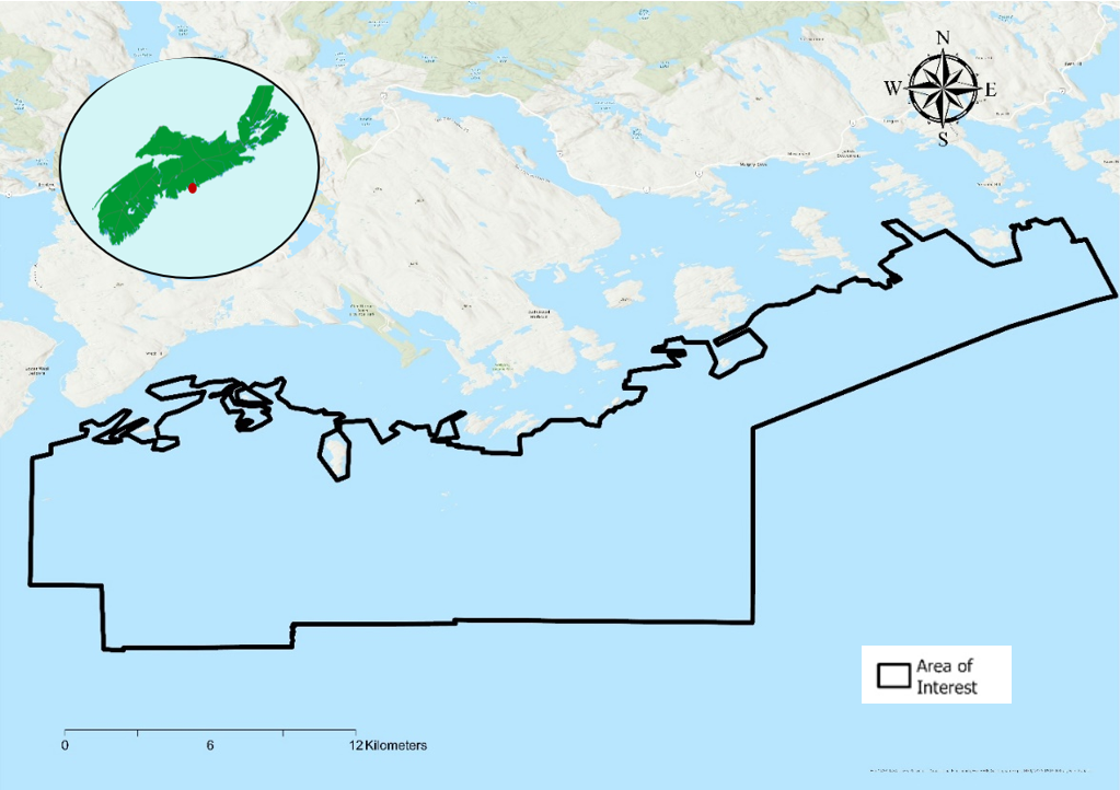
The aim of my study is to ask; Can we model carbon in the benthic environment using spatially continuous environmental dataset in the Eastern Shore Islands? I will use high resolution MBES surveys and other environmental predictor variables to model physically sampled percent organic carbon data. The study will focus on the Eastern Shore Islands, a potential marine protected area off the coast of Nova Scotia (Figure 3). The site has coastal sediments, making it less of a contained environment than previous studies which have predominantly taken place in fjords (C. Hunt et al., 2020; Smeaton & Austin, 2019). Also, this location has heterogenous seabed, which could provide insight on previously under-studied coarse-grained sediments with low mud contents (Diesing et al., 2017). The high-resolution sedimentary organic carbon map can act as a base map for determining future changes in the Eastern Shore Islands due to climate change. It can also help re-examine the importance of this marine protected area in providing climate regulation services and can be a tool for finding future carbon hotspots across the Scotian Shelf.
Next Steps
My next blog will be exploring how I combined my MBES surveys and environmental predictors variables (bottom salinity, bottom temperature, current, ruggedness and slope) to create an organic carbon map using the Forest Based Classification and Regression tool in ArcGIS Pro.
References
Asner, G. P., Hughes, R. F., Mascaro, J., Uowolo, A. L., Knapp, D. E., Jacobson, J., Kennedy-Bowdoin, T., & Clark, J. K. (2011). High-resolution carbon mapping on the million-hectare Island of Hawaii. Frontiers in Ecology and the Environment, 9(8), 434–439. https://doi.org/10.1890/100179
Asner, G. P., Mascaro, J., Muller-Landau, H. C., Vieilledent, G., Vaudry, R., Rasamoelina, M., Hall, J. S., & van Breugel, M. (2012). A universal airborne LiDAR approach for tropical forest carbon mapping. Oecologia, 168(4), 1147–1160. https://doi.org/10.1007/s00442-011-2165-z
Atwood, T. B., Witt, A., Mayorga, J., Hammill, E., & Sala, E. (2020). Global Patterns in Marine Sediment Carbon Stocks. Frontiers in Marine Science, 7, 165. https://doi.org/10.3389/fmars.2020.00165
BWSG_REPORT_MAY2015_web.pdf. (n.d.).
Diesing, M., Kröger, S., Parker, R., Jenkins, C., Mason, C., & Weston, K. (2017). Predicting the standing stock of organic carbon in surface sediments of the North–West European continental shelf. Biogeochemistry, 135(1–2), 183–200. https://doi.org/10.1007/s10533-017-0310-4
Diesing, M., Thorsnes, T., & Bjarnadóttir, L. R. (2021). Organic carbon densities and accumulation rates in surface sediments of the North Sea and Skagerrak. Biogeosciences, 18(6), 2139–2160. https://doi.org/10.5194/bg-18-2139-2021
Emerson, S., & Hedges, J. I. (1988). Processes controlling the organic carbon content of open ocean sediments. Paleoceanography, 3(5), 621–634. https://doi.org/10.1029/PA003i005p00621
Estes, E. R., Pockalny, R., D’Hondt, S., Inagaki, F., Morono, Y., Murray, R. W., Nordlund, D., Spivack, A. J., Wankel, S. D., Xiao, N., & Hansel, C. M. (2019). Persistent organic matter in oxic subseafloor sediment. Nature Geoscience, 12(2), 126–131. https://doi.org/10.1038/s41561-018-0291-5
Fourqurean, J. W., Duarte, C. M., Kennedy, H., Marbà, N., Holmer, M., Mateo, M. A., Apostolaki, E. T., Kendrick, G. A., Krause-Jensen, D., McGlathery, K. J., & Serrano, O. (2012). Seagrass ecosystems as a globally significant carbon stock. Nature Geoscience, 5(7), 505–509. https://doi.org/10.1038/ngeo1477
Hunt, C. A., Demšar, U., Marchant, B., Dove, D., & Austin, W. E. N. (2021). Sounding Out the Carbon: The Potential of Acoustic Backscatter Data to Yield Improved Spatial Predictions of Organic Carbon in Marine Sediments. Frontiers in Marine Science, 8, 756400. https://doi.org/10.3389/fmars.2021.756400
Hunt, C., Demšar, U., Dove, D., Smeaton, C., Cooper, R., & Austin, W. E. N. (2020). Quantifying Marine Sedimentary Carbon: A New Spatial Analysis Approach Using Seafloor Acoustics, Imagery, and Ground-Truthing Data in Scotland. Frontiers in Marine Science, 7, 588. https://doi.org/10.3389/fmars.2020.00588
Legge, O., Johnson, M., Hicks, N., Jickells, T., Diesing, M., Aldridge, J., Andrews, J., Artioli, Y., Bakker, D. C. E., Burrows, M. T., Carr, N., Cripps, G., Felgate, S. L., Fernand, L., Greenwood, N., Hartman, S., Kröger, S., Lessin, G., Mahaffey, C., … Williamson, P. (2020). Carbon on the Northwest European Shelf: Contemporary Budget and Future Influences. Frontiers in Marine Science, 7, 143. https://doi.org/10.3389/fmars.2020.00143
Osland, M. J., Gabler, C. A., Grace, J. B., Day, R. H., McCoy, M. L., McLeod, J. L., From, A. S., Enwright, N. M., Feher, L. C., Stagg, C. L., & Hartley, S. B. (2018). Climate and plant controls on soil organic matter in coastal wetlands. Global Change Biology, 24(11), 5361–5379. https://doi.org/10.1111/gcb.14376
Paradis, S., Goñi, M., Masqué, P., Durán, R., Arjona‐Camas, M., Palanques, A., & Puig, P. (2021). Persistence of Biogeochemical Alterations of Deep‐Sea Sediments by Bottom Trawling. Geophysical Research Letters, 48(2). https://doi.org/10.1029/2020GL091279
Sanders, C. J., Maher, D. T., Tait, D. R., Williams, D., Holloway, C., Sippo, J. Z., & Santos, I. R. (2016). Are global mangrove carbon stocks driven by rainfall?: Mangrove Carbon Stocks. Journal of Geophysical Research: Biogeosciences, 121(10), 2600–2609. https://doi.org/10.1002/2016JG003510
Smeaton, C., & Austin, W. E. N. (2019). Where’s the Carbon: Exploring the Spatial Heterogeneity of Sedimentary Carbon in Mid-Latitude Fjords. Frontiers in Earth Science, 7, 269. https://doi.org/10.3389/feart.2019.00269
Smeaton, C., Hunt, C. A., Turrell, W. R., & Austin, W. E. N. (2021). Marine Sedimentary Carbon Stocks of the United Kingdom’s Exclusive Economic Zone. Frontiers in Earth Science, 9, 593324. https://doi.org/10.3389/feart.2021.593324
Snelgrove, P. V. R., Soetaert, K., Solan, M., Thrush, S., Wei, C.-L., Danovaro, R., Fulweiler, R. W., Kitazato, H., Ingole, B., Norkko, A., Parkes, R. J., & Volkenborn, N. (2018). Global Carbon Cycling on a Heterogeneous Seafloor. Trends in Ecology & Evolution, 33(2), 96–105. https://doi.org/10.1016/j.tree.2017.11.004