
The Deeper Picture on Ghost Gear
Abandoned, lost or otherwise discarded fishing gear (ALDFG) is considered one of the most important marine debris issues that continues to threaten ocean sustainability. Globally, researchers are collectively working towards finding solutions to mitigate the impacts and reduce the presence of ALDFG in our oceans. Often, fishers don’t want to lose their gear, as it is expensive to replace. However, industry conflicts, entanglements, marine conditions, illegal fishing, and improper disposal can lead to gear ending up in the ocean. Spatial mapping has an important role in reducing this problem, because in order to retrieve ALDFG – also known as ‘ghost gear’ – it is important to know where to look.
While there are many international web applications to report marine debris, the Global Ghost Gear Initiative (GGI) has spearheaded the GGI reporter app, which allows the public and industry to report lost or found fishing gear. In 2019, Fisheries and Oceans Canada (DFO) launched a reporting system that is required in all groundfish and shrimp fisheries to monitor lost gear records. Mapping lost fishing gear allows organizations to target retrieval missions, and identify lost gear hotspots. Within the Canadian context, commercial landings and marine fisheries were valued at 3.6 billion in 2019 (Dawe et al., 2020), with the lobster fishery as the most profitable sector in the Canadian fishing industry, valued at 1.6 billion (DFO, 2019). Southwest Nova Scotia (SWNS) is considered the most productive regions for American Lobster in Canada, making it a prime region for large quantities of fishing-related debris.
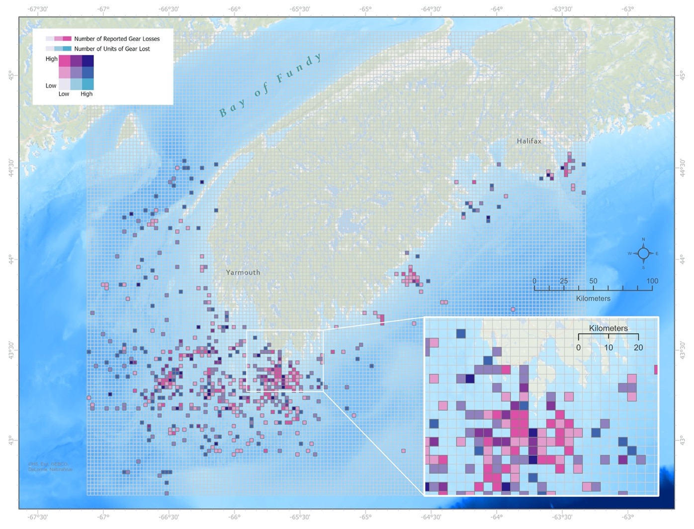
Data obtained by Fisheries and Oceans Canada.
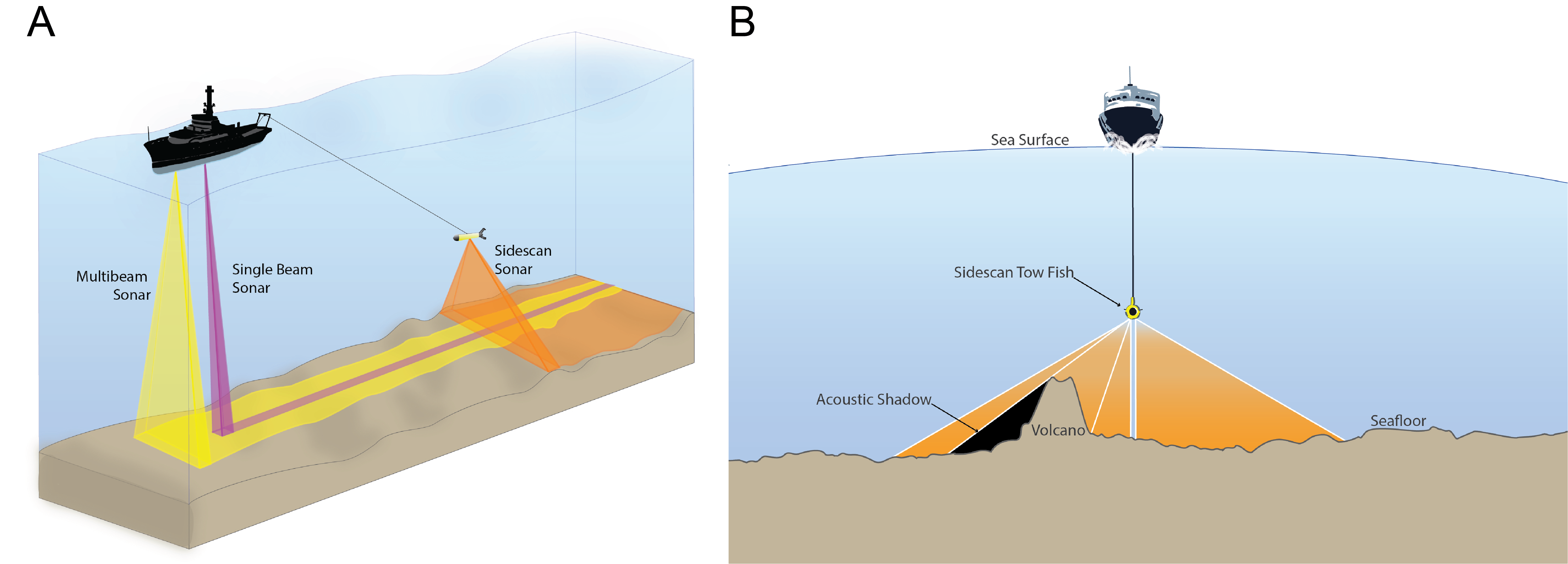
Removing gear from the ocean floor can present concerns related to interactions with at-risk species, sensitive habitats, high cost, and safety. Gear detection has been introduced as a method to pre-determine locations of abandoned, lost, or discarded fishing gear, with the intent to facilitate retrieval of ALDFG. In 2017, the Global Ghost Gear Initiative released “Methods to Locate Derelict Fishing Gear in Marine Waters” which highlighted side scan sonar (SSS) surveys as the primary tool for gear detection of ALDFG. These instruments are towed behind a vessel, and emit fan shaped acoustic pulses in order to produce an image of the seafloor. While international initiatives promote the applicability of side scan sonar as a gear detection method, limited published research is available pertaining to the detection of ALDFG and how this affects the subsequent success of retrieval operations.
Searching the seafloor
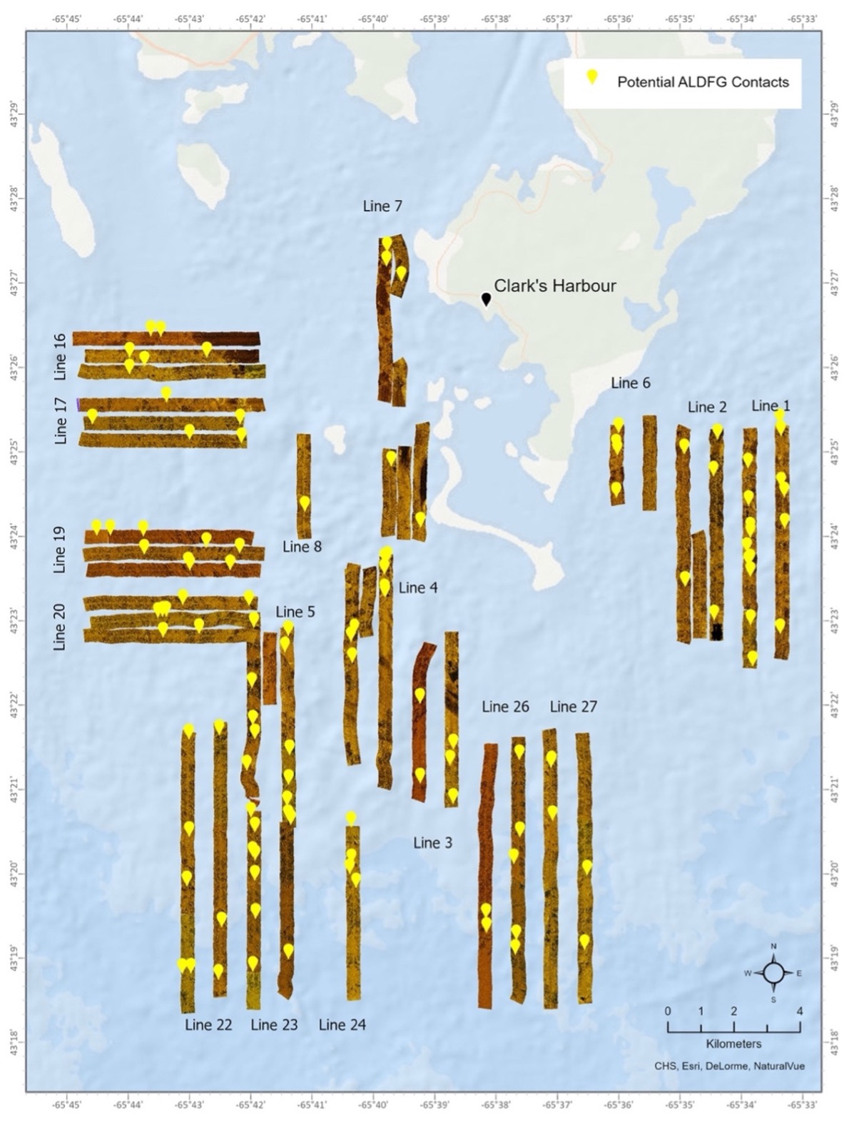
In June 2021, 27 SSS transects were conducted in Lobster Fishing Area 34 over a 12-day survey period in Clark’s Harbour, Nova Scotia, to evaluate the benefits of gear detection in large-scale retrieval missions. The preliminary identification of ALDFG targets prior to post-processing of the side scan sonar data revealed 161 targets identified. These targets were provisionally identified as lobster traps and other unidentified marine debris. The second comprehensive review of the side scan following post-processing of the data concluded a total of 114 potential targets, revealing that many of these initial targets were unlikely to be ALDFG.
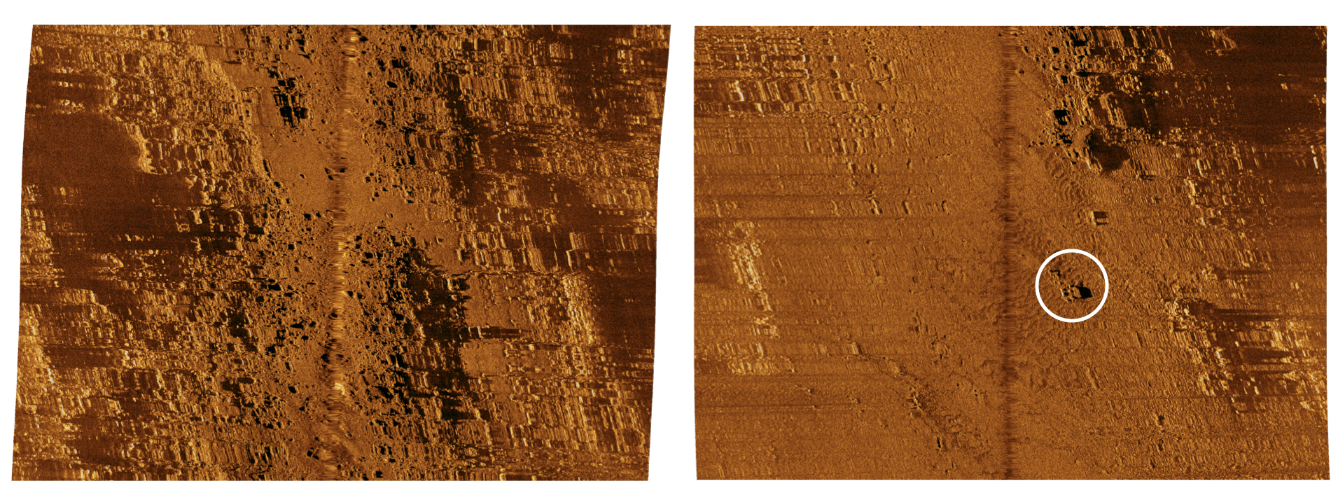
The seafloor habitat visible from the side scan sonar backscatter was classified as either “smooth/homogenous” or “complex habitat”. Smooth/homogenous habitats were defined by areas of low-intensity backscatter, representing unconsolidated low relief substrate (e.g., sand, mud, or mixed sediments). In contrast, complex habitats were characterized by higher intensity backscatter and regions of acoustic shadows, indicative of high relief and complex topography typical of hard bottom, rocky habitats (e.g., outcropping bedrock reefs, moraines, and cobble and boulders). The secondary review of the data reduced the number of potential ALDFG targets, where the reduction was attributed to the challenges of identifying targets on complex bottom types. Side scan sonar survey data were shared with retrieval fishers to target lost gear found from the imagery; however, only one item was confirmed retrieved, which represents the challenges associated to gear retrieval in dynamic ocean environments.
All hands on deck
The results highlighted discussion points related to gear detection planning and operation, derelict gear identification, application to large-scale retrieval missions, costs to operate, and alternative uses. Most significantly, the results emphasized that knowledge of prime fishing locations and prioritizing identified hotspots through geospatial analyses of reported gear losses may be the most direct way at targeting retrieval areas. Given the low success rate and high expenses to apply SSS for large-scale retrieval missions, it is recommended to use side scan sonar at finer spatial resolutions, such as sensitive ocean floor habitats. However, a combination of qualitative and quantitative analysis will ultimately strengthen and increase retrieval activities’ precision while potentially improving the likelihood of success. Retrieval fishers hold a wealth of knowledge that can be pivotal if incorporated in the gear detection process, which may ultimately contribute to higher gear detection and retrieval success rates. An example of including fishers in gear detection planning could include a participatory mapping exercise to inform seafloor mapping design strategies, as well SSS deployment and retrieval. As gear detection presents a significant cost, organizations are urged to evaluate the benefits of the application and coordinate missions based on a combination of fishing pressures, reported gear losses, environmental parameters, and fisher’s knowledge in future applications.
Interested in learning more on ghost gear retrieval in Southwest Nova Scotia? Check out the StoryMap “The Tale of Lost Fishing Gear”.
This project is part of the larger “Collaborative Remediation of Abandoned, Lost and Discarded Fishing Gear in Southwest Nova Scotia” led by Coastal Action, and funded by Fisheries and Oceans Canada (DFO) through the Sustainable Fisheries Solutions & Retrieval Support Contribution Program (Ghost Gear Fund).