
GIS Beyond Earth
When we think about GIS in our everyday lives, we typically consider the ways it benefits us here on Earth. From mapping natural disasters to planning the intricate details of new urban areas, GIS has transformed the way we use and visualize spatial data. However, unbeknownst to many of us, GIS has many applications in a field that goes far beyond Earth: space exploration.
Planetary Mapping
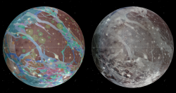
The large collections of planetary images taken over the years by various spacecraft have served as the basis for many surface and 3D maps of planetary bodies. These feature-rich maps help build our understanding of the geology, topology and geography of these planetary bodies [1] and, in some cases, aid in the planning of future space missions. For example, the image below uses imagery from NASA’s Voyager 1 and 2 spacecraft along with its Galileo spacecraft to create a base mosaic (right) which serves as a base map for a detailed geologic map of Ganymede (left).
GIS is not limited to planetary bodies, however; astronomers have created dynamic maps of the universe that can be modified based on astronomical projections or sensor data from satellites and telescopes. As well, new imaging technologies and new signalling capacity on spacecraft have enabled the creation of more realistic 3D maps that can monitor space events in real-time – even the projection of black holes! [2]
GIS Applications
The images and data collected by both spacecraft and rovers has sparked the creation of many exciting and unique applications. As a result of its “close” proximity and recognition as a target for future missions, Mars has been the star of several notable applications. For example, JMARS, a GIS developed by the Arizona State University Mars Space Flight facility, is used to provide mission planning and data analysis tools to NASA scientists, facility team members, students and the general public. [2] NASA has used extensive data from their Mars Odyssey mission to create detailed surface maps as well as a geoid of the planet using the THEMIS camera system. [2] NASA has also completed GIS projects relating to path planning – specifically, finding the best paths for rovers and humans on Mars. Other notable applications include several developed by the United States Geologic Survey (see here and here).
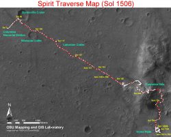
Traverse map of NASA’s Spirit Rover. |
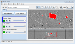
Example of using shape layers in the JMARS application. |
Even Google Maps has come out with a space layer using images taken from a multitude of spacecraft. Users are able to explore many different planets and moons, and, if they zoom in enough, view various features and their associated names.
Final Thoughts
GIS is a powerful tool that has limitless possibilities when applied to the realm of space exploration. To NASA, GIS has become “a crucial part of getting to know the features of other worlds” [2] and, to the general public, it has become a way of exploring the universe and learning more about our celestial neighbours. I hope that GIS continues to aid in the exploration of space and inspires the GIS community to keep their eyes to the sky. To space and beyond!
References:
[1] https://gis.usc.edu/blog/how-mapping-is-used-by-nasa-applications-of-gis-in-space/
[2] https://www.gislounge.com/using-gis-space-exploration/