
DGGS: A New Way to Model Geospatial Information
A few weeks ago, I attended the 2018 Esri Canada User Conference in Fredericton, New Brunswick. As this was my first GIS conference, I learned a lot from the user presentations and technical sessions given by Esri Canada staff, as well as other students and industry partners. It was eye-opening to see how GIS can make such a substantial impact on so many different fields. One presentation in particular piqued my interest, as it was unique within the scope of the conference. It was titled “Modelling, Analysis and Visualization of Vector Data on a Quadrilateral Discrete Global Grid System” and was presented by David Bowater, a graduate student at the University of New Brunswick.
The objective of David’s presentation was to briefly highlight the potential of Discrete Global Grid Systems as the globe-based future of GIS and to show simple examples of how vector data can be modelled, analyzed and visualized on a quadrilateral Discrete Global Grid System (DGGS). His specific area of research was the application of the rHEALPix DGGS in Canada. During his presentation, he noted that the Open Geospatial Consortium (OGC) very recently announced DGGS as a new standard that aims to change the way geospatial information is spatially referenced to the earth.
As I found this topic both fascinating and exciting, I decided to give a brief introduction to DGGS here in a blog post!
What is DGGS?
The OGC defines a DGGS as:
“a spatial reference system that uses a hierarchical tessellation of cells to partition and address the globe” (Purss, 2015)
To put it simply, a DGGS is like a spreadsheet of uniform tiny cells that cover the entire earth. Each cell has its own unique “address” and can be subdivided repeatedly to provide increasingly finer spatial resolution. It can store specific information about the condition of an area and the events describing a place within its bounds, whether it be scientific, qualitative, or anything in between. For example, geospatial data values from any source, type, format, spatial reference, spatial scale, or frequency can be held in a DGGS cell (Peterson, 2016).
What is its purpose?
The primary goal of DGGS, according to OGC, is to enable the rapid assembly of spatial data without the difficulties of working with projected coordinate reference systems (OGC, 2017). It is not meant to be used as a navigation grid, like the common latitude/longitude coordinate system; rather, it is designed to be an information grid for tasks such as data modelling, processing, storage, transmission, visualization and analysis. For example, if this standard were used globally, everyone would use the same fixed cells to record and analyze everything from crowd-sourced events to precise scientific observations. It would become easy for a user to determine where certain conditions exist and what is happening at any desired location (Peterson, 2016).
The technical side
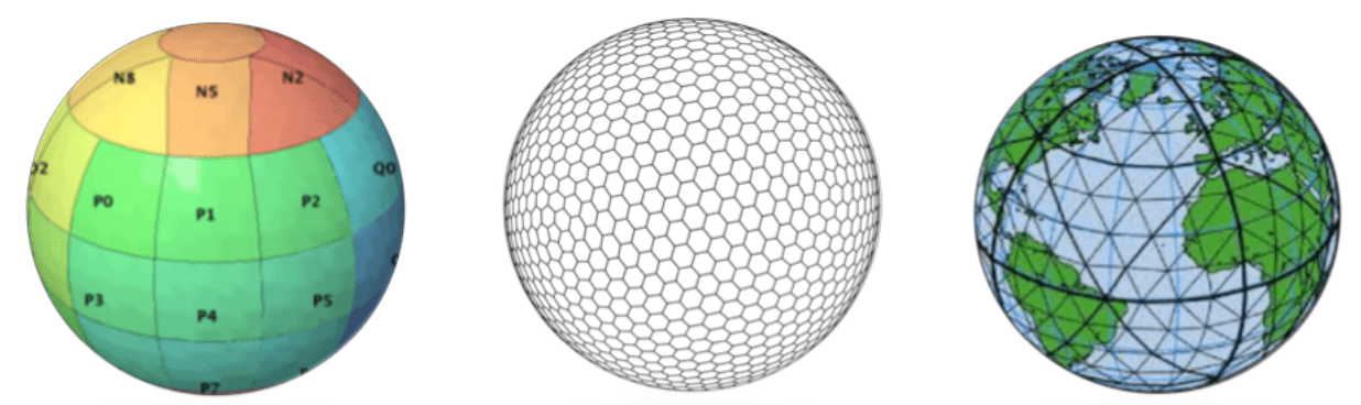
A DGGS uses solid polyhedrons, such as tetrahedrons, cubes, or octahedrons, to model the earth. These tessellations are inversely projected on a sphere or ellipsoid to create the reference system, as shown below (Kumar, 2017). There are many different implementations of DGGS that have been established globally, each with their advantages and disadvantages.

Pictured below are a few different examples of DGGS based on a few of the platonic solids outlined above:
So what’s the big deal?
DGGS has a unique capability in that it allows raster, vector and point cloud data to be combined into a common, globally consistent framework (OGC, 2017). By nature of its algorithms, it can analyze large amounts of data very quickly, which makes it a great candidate for working with “geographic big data”. This is a tremendous opportunity in our current data-driven society, as the amount of data being produced each year is increasing rapidly.
Another key characteristic of DGGS is that it allows multiple data sources to be integrated and analyzed in one workflow without the need to convert or change spatial reference systems (Peterson, 2016). It enables a user to work with and analyze many types of data at once, which could have enormous benefits for large projects or work involving time-series data. DGGS also accurately portrays polar regions just as well as any other region in the world (finally!).
Members of the global geodesy community have expressed reservations about using DGGS over conventional coordinate reference systems, especially when it comes to the fields of geodesy, engineering or hydrography. Part of their reasoning is that there is a vast amount of spatial data in these fields that is referenced to coordinate systems that will continue to be maintained in that form. As well, if the use of ellipsoidal coordinates (latitude and longitude) ever declined, it would most likely be associated with an increase in geocentric Cartesian coordinates rather than cell-based reference frames (Lott, 2017).
However, in the future, DGGS could become a key player in fields such as geo-statistical analyses, environmental sciences and remote sensing, especially where the study areas are extensive (Lott, 2017). Currently, there are at least 10 DGGS implementations in active development and use, and hopefully there will be many more in the near future!
For those interested in reading the entire DGGS Abstract Specification, here is the link from OGC:
http://docs.opengeospatial.org/as/15-104r5/15-104r5.html
And a full overview by Perry Peterson, the president of Global Grid Systems:
References:
Kumar, T. P. (2017, October 30). Discrete Global Grid System (DGGS) – A new reference system. Retrieved November 3, 2018, from http://geoawesomeness.com/discrete-global-grid-system-dggs-new-reference-system/
Lott, R. (2017, January 24). Lats and longs, WGS84 or DGGS? Retrieved November 3, 2018, from http://www.ee.co.za/article/lats-longs-wgs84-dggs.html
OGC.(2017, October 24). OGC announces a new standard that improves the way information is referenced to the earth. Retrieved November 3, 2018, from http://www.opengeospatial.org/pressroom/pressreleases/2656
Peterson, P. (2016, May 16). Bring It All Down to Earth with DGGS. Retrieved November 3, 2018, from http://apogeospatial.com/2079-2/
Purss, M. (2015, September 30). Topic 21: Discrete Global Grid Systems Abstract Specification. Retrieved November 3, 2018, from http://docs.opengeospatial.org/as/15-104r5/15-104r5.html