To Kampala and Beyond
Hello Esri family,
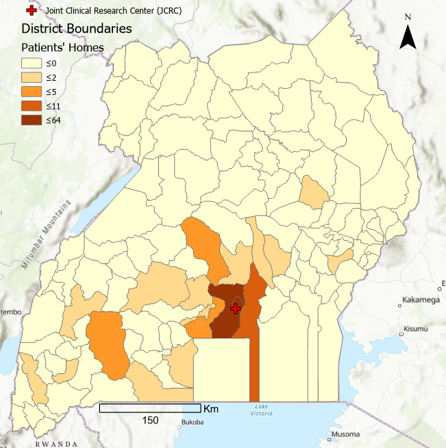
My name is Gabrielle Bruser and I am a second year Masters student in Health Geography. I am new to the Esri Canada Centre of Excellence (ECCE), and I wanted to introduce myself and share my progress with my research (or lack thereof). I spent the last summer collecting data at the Joint Clinical Research Center (JCRC) in Kampala, the capital city of Uganda. The JCRC is a health facility that provides HIV treatment, as well as other health services, to hundreds of thousands of people in and around the Kampala area. The JCRC staff are interested in knowing the spatial distribution of their patients, so that they can provide specialized health services based on community needs. The JCRC is located just outside Kampala, indicated with the red cross in Figure 1. However, patients living hundreds of kilometers away travel to get their medication from the JCRC. Travel across Uganda is no easy feat, with buses that regularly break down and frequent car accidents. There are also many other hospitals and treatment facilities throughout the country, so why are they traveling so far to get their medication? I will attempt to answer this question in future posts.
I am currently in the “playing with the data” phase. For this reason, the figures below are nowhere near a finished product. Figure 1 shows the distribution of my study sample (n=149). Evidently, the majority of patients are clustered around Kampala, but a number of them are scattered in different directions. What is illustrated here represents only the number of patients’ homes. However, many people also travel long distances for work and school. My point being, there is an explicit geographical element in HIV treatment. My objective in general is to use GIS to conduct a spatial analysis of the patients’ transportation network, including their commute to the clinic. I will admit that this is easier said than done. It took me about a month just to figure out how to convert hundreds of kml files into one shapefile, despite the fact that I’ve taken several courses on GIS. Learning definitely never stops. I learned initially using ArcMap, and for a while I was stubbornly attached and refused to even look at ArcGIS Pro. However, over the past couple months, ArcGIS Pro has proved to be the better option on more than one occasion, and it isn’t actually that difficult to find where everything is, so I am slowly being converted into an ArcGIS Pro user.
I am looking forward to furthering the development of my GIS skills with the ECCE, and hope to have fancier and more conclusive maps to share with the blog in the near future. Till next time!