
Exploring Historical and Modern Toronto With ArcGIS Pro
Near the end of the first semester of my MSc Geography program, I was looking over the City of Toronto Open Data Portal “Green Spaces” file (City of Toronto, 2022) layered over a Natural Resources Canada high resolution DEM (Natural Resources Canada, 2019) when I noticed that, in addition to the connected parks lining the river and ravine systems of the city, the southern part of the city contained disconnected parks that traced lines of low elevation. I was curious about this connection between low elevation and parks, and after some research I came across the “Lost Rivers Dataset” produced through the Lost Rivers Project (Fortin, 2022). Overlaying this rivers dataset on top of the parks and elevation layers demonstrated a relationship between lost rivers—historical rivers have been buried or filled in—and a number of Toronto’s downtown parks.

I analyzed the relationship between lost rivers and Toronto greenspace and land use planning for a course paper, with Garrison Creek as my case study. Garrison Creek formerly ran from around Davenport Road down to the historical shore of Lake Ontario, close to the current Fort York National Historic Site (Robertson & Stewart, 2008). The creek was seriously polluted by the 1880s (“Cholera Scourge,” 1883) and over the late 19th and early 20th centuries it was enclosed in a brick sewer (“Garrison Creek Will Be No More,” 1911). A series of parks emerged around the sewer during and after its construction, and efforts by architects (Brown and Storey Architects, 1996) and community groups in the 1990s and beyond brought attention to these parks as part of an underlying lost river system (Toronto Community Council, 1998).
After writing my paper, I wanted to see how I could further visualize the relationship between the former Garrison Creek, the historical Garrison Creek sewer, and Toronto’s current terrain. I acquired an 1888 sewer map from the Toronto Public Library (“Map,” 1888) and georeferenced it by setting control points along the line of the 1888 sewer.
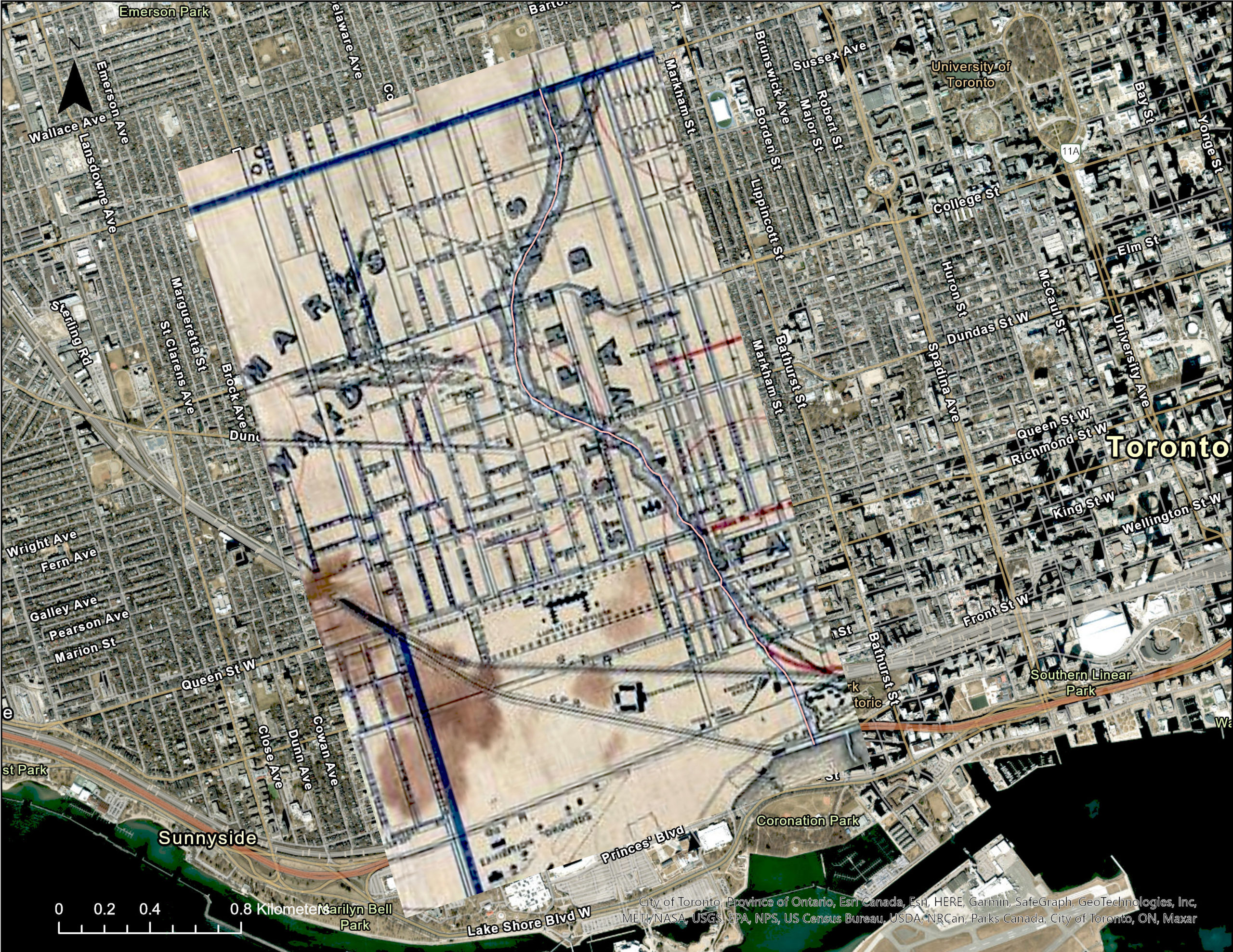
After that, I manually digitized the sewer line, set its elevation to that of the modern DEM, and added it to a 3D local scene with the Green Spaces layer and the Lost Rivers layer.
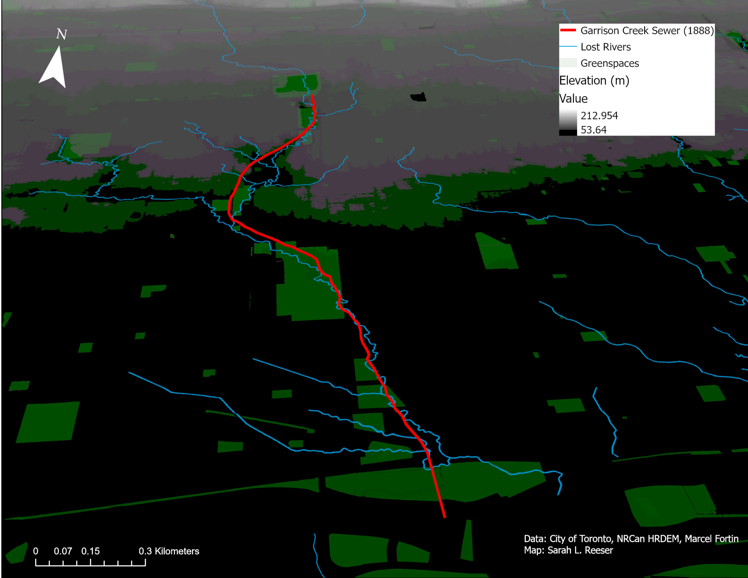
The digitized 1888 sewer line does not line up exactly with the Garrison Creek lost river line. The 1888 map was mostly proportional to the modern Esri base layer, but there were distortions in sections with denser street grids, including many of the areas along the sewer. While the residual differences between the control points on the 1888 and modern maps were generally under 20 meters, this was enough to produce an evident offset on such a local scale. The divergence of the sewer line from the historical creek may therefore be exaggerated in places, and the digitization potentially provides a view of the relationship between the 1888 map’s depiction of the sewer and today’s terrain, rather than the actual 1888 sewer itself and the terrain.
Additionally, the Garrison Creek sewer ran under and not on top of the terrain, as depicted here. An underground view was not possible with my current data, as a number of elevation changes occurred along the sewer line in the 19th and 20th centuries when the ravine areas that lined the creek were filled in, and I do not have the depth measurements for the 1888 sewer. I decided instead to drag the lost river and the sewer up to the surface, so to speak, in order to visualize the overlap of natural and built features across time.

The Toronto of the 1880s has been described as “the palimpsest” of years of surveying and land use decisions (Ganton, 1982, p. 220). The visualization above represents an updated version of this palimpsest as the creek, the sewer, and the park system—each of which represent distinct moments of planning decisions and topographical alterations—are displayed simultaneously. While a series of layers would present these alterations as a sequence in time, this image leads me to consider the ways in which the effects of such planning decisions are combined and evident on the surface of the landscape. Flooding from major weather events, for example, or the placement of the parks along the path of the former Garrison Creek demonstrate the ways in which the above image of condensed time and space can come to life and interact with the current city and its residents.
Works Cited
Brown and Storey Architects. (1996). Rainwater ponds in an urban landscape: Garrison Creek demonstration project report. https://www.brownandstorey.com/project/garrison-creek-study/.
“Cholera scourge: Needful precautions to be taken against its spread Dr. Oldright advises-Condition of Garrison Creek-University Creek-Filthy lanes-Some suggestions.” (1883, Aug. 1). The Globe (1844-1936). https://www.proquest.com/docview/1532165102/fulltextPDF/.
City of Toronto. Green Spaces (July 14, 2022) [Data set]. Open Data Portal: Parks, Forestry and Recreation. https://open.toronto.ca/dataset/green-spaces/.
Fortin, Marcel. (2022). Lost Rivers — Disappearing Rivers of Toronto [Data set]. Borealis, V3. https://doi.org/10.5683/SP2/2AHETH.
Ganton, I.K. (1982). Land subdivision in Toronto, 1851-1883. In Stetler, G.A. & Artibise, A.F.J (Ed.) Shaping the urban landscape: Aspects of the Canadian city-building process, 200-231. Carleton University Press.
“Garrison Creek will be no more: City engineer recommends an apportionment of 325,000 to cover it for a sewer.” (1911, April 7). The Globe (1844-1936). https://www.proquest.com/docview/1351162414/fulltextPDF/.
“Map of the City of Toronto shewing [sic] intercepting sewers and sewers already constructed.” (1888). Courtesy of Toronto Public Library. https://digitalarchive.tpl.ca/objects/320523/map-of-the-city-of-toronto-shewing-proposed-intercepting-sew?ctx=6a7ee19c7253cc7c5fd265678c114bd71f896427&idx=0.
Natural Resources Canada. (2019). High Resolution Digital Elevation Model (HRDEM)-York2019. [Dataset]. CanElevation Series. https://search.open.canada.ca/openmap/957782bf-847c-4644-a757-e383c0057995.
Robertson, D.A. & Stewart, A.M. (2008). The Garrison Creek mouth and the Queen’s Wharf: Digging up 200 years of shoreline development. In Reeves, W. & Palassio, C. (Ed.) HTO Toronto’s water from Lake Iroquois to lost rivers to low-flow toilets, 146-153. Coach House Books.
Toronto Community Council. (1998). Garrison Creek Open Space Linkages Plan. https://www.toronto.ca/legdocs/1998/agendas/council/cc/cc981001/to11rpt/cl092.htm. (Note: If hyperlink does not work, copy and paste address into search bar)