
Teaching with GIS
Geographic information systems (GIS) can be intimidating at first glance for the unfamiliar person. Esri has made some excellent progress in developing more intuitive point-and-click applications such as ArcGIS Online and ArcGIS Pro, however, there is a steep learning curve in using a GIS. Over this past term, I have had many opportunities to introduce people to GIS using Esri products. In these experiences, I’ve learned a few lessons about what works (and what does not work). First, show people the entire lifecycle of GIS. Second, use more visuals and hands-on examples as an introduction to more complex tasks. Third, know your audience’s expectations when teaching GIS.
1_Lifecycle
This past term I was a teaching assistant for a third-year geography course on land use and development issues. Students are given a project from a community partner to work on over the term. In addition, they are taught various community geography field techniques – traffic counts, building audits, systematic reviews, policy scans – to help them gather data for their projects. The use of GIS comes up in many of these projects, so it is a focus area when teaching these techniques. Rather than giving students one lab on GIS, we use Esri technology throughout the research lifecycle.
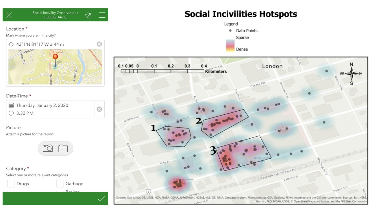
First, they collect their data with the Survey123 field app. Next, we interact with the data via Esri’s ArcGIS Online platform. Finally, we use ArcGIS Pro to manipulate the data, and create a map that communicates a story about the data. I find this lifecycle approach to be incredibly powerful in showing students how GIS can benefit their projects and future work. I was particularly impressed that I could have two students with no geography background learn how to collect data with Survey123, export it to ArcGIS Pro, and run a great analysis on social incivilities in the downtown London, Ontario area (Figure 1). I think the benefit of training people in the lifecycle of GIS is that it shows them how a component of Esri’s technology replaces a paper-based process (data collection) or labour-intensive way (drawing a map) of completing a task.
2_Visuals
Many times this past term I found myself helping undergraduate students, graduate colleagues, and members of public understand their work, research, and challenges using GIS. In all of these experiences, I found the most effective way of working with people was showing them visually how to work with GIS technology. I found Survey123, Web AppBuilder for ArcGIS, and the Tasks feature in ArcGIS Pro to be useful in setting people on the right path. Survey123 is a great way to show people how to think about their data in spatial way. Web AppBuilder for ArcGIS is an easy way to quickly create interactive maps and dashboards that can be used to share and collaborate on a challenge using GIS technology. The Tasks function in ArcGIS Pro is a brilliant new feature to partially automate routine tasks, and guide people through the proper sequence of commands to solve a problem, or create an output with Esri technology.
3_Audience
A local health unit approached our lab at Western to train them in GIS, particularly in how to use their Esri products. We originally embarked on crafting a workshop that would guide them through the basics of working with GIS, and on the differences between points, lines, and polygons. However after having another discussion ahead of the day we realized that the value we could provide them was not training in how to use GIS technology, rather it was sharing our experiences in using GIS and demonstrating the advanced capabilities of Esri products. I drew from this experience that it is critical to always understand your audience’s needs and wants – do not always jump to the most complex or hands-on approaches.
I am looking forward to incorporating these three lessons into future teaching activities and collaboration with community partners.