
Using across-method triangulation to supplement location information
There is growing attraction for social and behavioral scientists to apply geographic information systems (GIS) theory and methods. The term “geocoding” is now commonplace amongst population health researchers and draws attention to connecting attributes of people to the characteristics of place. Partly due to the increasing availability and access to locational information, researchers are now geocoding data to apply spatially integrated perspectives of social and physical space such as where people live, work, and play. It is an exciting time for researchers across multiple disciplines outside of geography to discover new and important spatially integrated research questions. As more interdisciplinary areas of research emerge, it is surprising there are few discussions of the limitations, inaccuracies, and methodological challenges associated with integrating spatial methods to investigate spatial patterns within secondary data sources. This blog post discusses my experience working on a social science research project led by Dr. Howard Ramos called “Perceptions of Change” and the use of across-method triangulation to supplement locational information and subsequent data linkage of environmental variables.
The majority of health researchers within Canada use postal codes, which are a commonly available source of individual geographic identifiers for geocoding purposes. The use of postal codes to identify point location presents many challenges and limitations including: 1) poor match rates or incomplete matches from inaccuracies of invalid alpha-numeric characters entered, or the restricted use of partial postal codes (e.g., FSAs) for assigning locations; 2) misclassification errors, where geographic coordinates or boundaries are incorrectly assigned to geographic boundaries even when valid, accurate postal codes are available; and, 3) accurate linkage of contextual or socio-spatial data from different data models. Addressing any number of these limitations is often difficult, given there are few technical resources available to assist in validating or improving the accuracy of locations through geocoding. One of the main objectives of this study was to improve completeness and positional accuracy of postal code locations through triangulation and to improve subsequent data linkage for spatial analysis of social and environmental data. Improving completeness and positional accuracy of postal code locations was important when I attempted to link raster data of environmental measures for air quality and greenspace to participant’s home address.
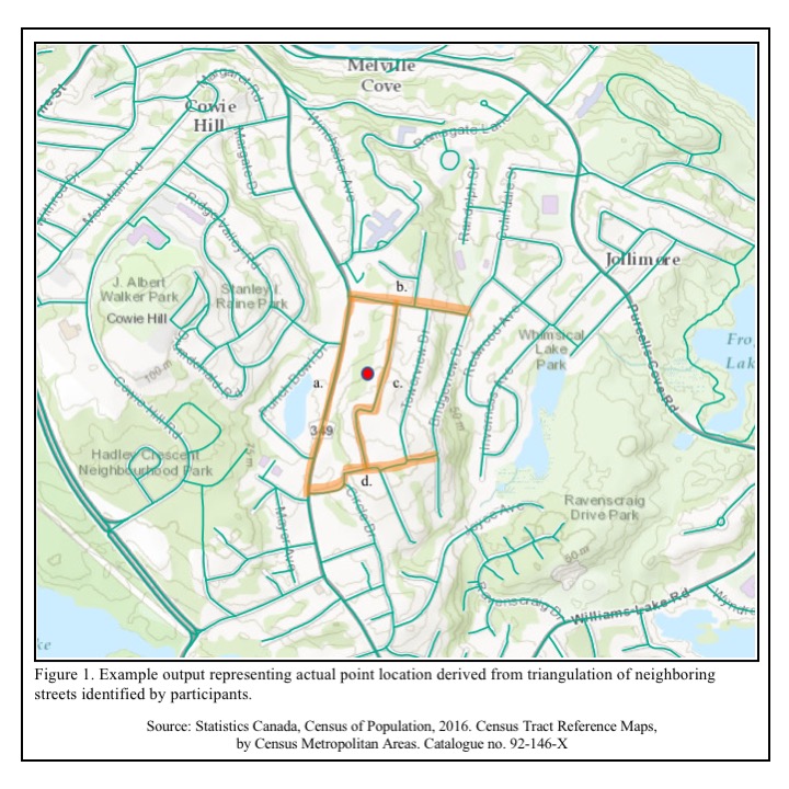
Through the use of creative survey questions, across-method triangulation was applied to gather quantitative and qualitative sources of data to confirm participant home addresses and completeness of data. The purpose of this study was to ask participants from Halifax, Charlottetown, St. John’s, and Moncton questions about the changes they have observed, within their neighborhoods and the city as a whole, and how they felt about those changes. The survey consisted of a total of 75 open and closed-ended survey questions regarding perceptions of change as well as questions to identify their neighborhood and home address. Specifically, participants were asked questions to identify their neighbourhood name (if any), postal code, and the names of any streets that they perceive to define their neighbourhood. To prevent high non-response rates and loss of participant rapport there was not a question asking for participants home address. Data gathered from these survey questions provides an opportunity to explore how participants define the boundaries of their neighbourhood, and to provide additional geographic information, i.e., neighbourhood and street names, to assist in improving locational accuracy of postal code geocoding results from PCCF+. By obtaining the names of streets adjacent to the participant’s home address we were able to correct a significant portion of postal code records with data entry errors. Postal codes were then triangulated to ensure positional accuracy of results from PCCF+ across different levels of geography within census boundaries, particularly across areas of concern in rural regions. The series of survey questions provided researchers with information to narrow participants’ general location through neighborhood name and then identify more accurate location by obtaining names of streets adjacent to participants’ home address. Figure 1 provides a visualization for the process of identifying participant point locations and improved accuracy derived from triangulating neighboring streets. The use of triangulation allowed our team to recover many cases that would have been removed due to data entry errors. Postal codes were also triangulated to ensure positional accuracy and reduce errors from misassignment by the PCCF+.
The use of survey questions to supplement geographic identifiers for geocoding is not a novel idea for geographers, however this approach raises an important issue for researchers interested in applying spatially integrated research methods. A gap in knowledge within many social science geospatial approaches is the reliance upon quantitative spatially referenced datasets and the lack of qualitative spatial contexts that are central to study design and inquiry of socio-spatial phenomena. Geocoding results provide spatial patterns for one data point in space and time with little information of important contextual factors such as characteristics of human behavior and how or why people interact within their built environment. There is a need for health and social science researchers to apply a more in-depth inquiry for gathering locational information beyond one point in space and time represented from postal codes. Researchers should be encouraged to think critically about spatial theories within their study design, such as Hägerstrand’s theory of time-geography, as a framework for analyzing contextual factors across individual space-time activities to better understand patterns of health and social behaviors. Researchers should consider how different spatial data can be gathered through both qualitative and quantitative methods and attributed to individuals across different dimensions of their environment to contextualize space-time activity paths. There is a need for social science and health researchers to advance socio-spatial theories through use of mixed-methodology for addressing complex health and social problems.
My experience of working on this research project has increased my awareness of the value in applying a mixed methods approach to gather a more complete and in-depth understanding of complex health issues connecting people, time, and place. There are a broad range of geospatial theories and methods that are critical for advancing population health strategies by strengthening connections between community-level contexts and interventions of prevention through behavior change. As I embark on my doctoral research, I am eager to apply geospatial theories with mixed-methods to supplement quantitative measures of individual time-activity space with qualitative contexts of community-level characteristics to inform population health interventions for prevention of chronic disease.