
Valuable Experience from the 2019 ECCE App Challenge
Check out more details about the App Challenge team ‘Awesome Engineers’ and the app that Xuyang Han writes about below on the team’s profile page.
Earlier this year, three engineering students at York University, Xuyang Han, Muhammad Usman and Aman Ullah attended the 2019 Esri App Challenge. I would like to share this valuable experience through this blog.
The App Challenge is a coding competition held by Esri Canada to help promote innovation and creativity within the Centres of Excellence. We are given one week to create new and unique apps powered by Esri technology and open data to help address city-planning and environmental problems. After brainstorming, we decided to develop a ride-sharing platform, to reduce traffic carbon emission and thus reduce the influences on climate change.
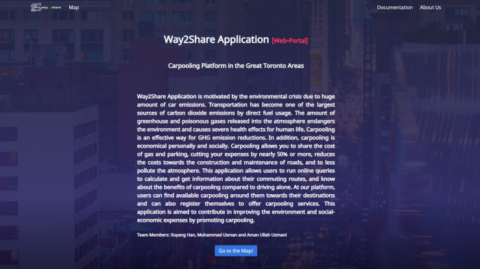
The motivation behind this App is the environmental crisis due to a huge amount of car emissions. Transportation has become one of the largest sources of carbon dioxide emissions by direct fuel usage. The amount of greenhouse and poisonous gases released into the atmosphere endangers the environment and causes severe health effects for human life. Carpooling is an effective way for GHG emission reductions. In addition, carpooling is economical personally and socially. Carpooling allows you to share the cost of gas and parking, cutting your expenses by nearly 50% or more, reduces the costs towards the construction and maintenance of roads, and reduces atmospheric pollution. This application allows users to run online queries to calculate and get information about their commuting routes, and know about the benefits of carpooling compared to driving alone. With our application, users can find available carpooling around them for their destinations, and can also register themselves to offer carpooling services. This application is aimed to contribute to improving the environment and social-economic expenses by promoting carpooling.
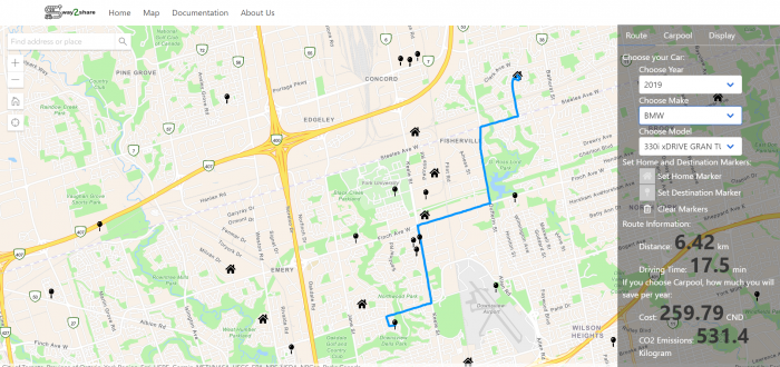
Our application was created using the ArcGIS API for JavaScript to design the front-end interface. We also built an ArcGIS database for the backend to store the route information. The App has three main functions: get route information, query available carpooling, and share your route with others. Route information is provided to the user after the user has input details about their trip.
Users can set home and destination and select the car by year, make and model. The route will be generated automatically and associated values about the route are presented, including distance, the driving time needed, CO2 emissions, and Cost.
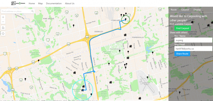
If users without a car want to find available carpooling, they set a home and destination then click the green ‘Find Carpool’ button to get query results of available carpools. People 1km around you and with the same destination will be shown on the map, and you may contact them by email. Users with a car can also share their route with others. Users can set a home and destination location to generate the route, input their name and email, and submit it. Users’ info will be uploaded into the database and will be open to other users within 1km. Other people with a similar route will be able to find you and contact you by email to arrange carpooling.
Data used in the creation of our web application came solely from open data sources. Data on fuel consumption ratings, fuel price and other facts data are from Statistics Canada.
Due to the time limitation of the app challenge, plenty of tasks on our list were not completed. Some desired functionalities for future work are listed as follows:
- User registration functionality. Only registered users will access to query available carpools. The public can only use route information estimation without registration.
- User permissions. Users will have permissions to change the data records they submitted.
- User records. Users will know how much contributions are done towards the environment in saving Fuel, CO2 emissions and Costs.
- More comprehensive vehicle information and support calculation for more than 2 people sharing the route.
Overall, the App challenge was a valuable experience for me to practice programming skills, web application development, and organizing teamwork communication. Definitely, this experience is super helpful for understanding Esri products and future career preparation. I strongly recommend every student in related majors get actively involved in this activity, and I hope we can be the winner and go to San Diego next year!