Working towards a National Imagery Strategy – Notes from a 3D-Data Workshop
The booming world of 3D Technology is more compelling than I anticipated.
In the last week of January, the Canadian Institute of Geomatics (CIG) Nova Scotia Chapter and the Geomatics Association of Nova Scotia (GANS) held a 3D-Data Workshop at the Centre of Geographic Sciences (COGS).
Hundreds from industry, non-profit, academia, and all levels of government registered to discuss and promote 3D technology.
After 2 days of 24 presentations and demos, I walked away with 10 pages of notes and a drastically increased respect for the 3D industry. One of the most exciting presentation topics from a student’s perspective was regarding work toward a National Imagery Strategy:
Presented by Mr. Proulx-Bourque on behalf of the
Canada Centre for Mapping and Earth Observation (CCMEO)
Towards Country Wide High-Resolution Elevation Data
Jean-Samuel Proulx-Bourque is a senior project officer for the CCMEO office in Sherbrooke, Quebec. He presented the status of several ongoing projects, including CCMEO’s work toward country wide high-resolution elevation and imagery. The National Imagery Strategy (proposal to be submitted in March, 2018) will aim to provide an online service for the public to visualize and download elevation data; data that is accessible and open. The hope is for better than 0.7 meter resolution data, which if possible, would be an amazing source for researchers or non-profit organizations who can’t afford to spend thousands of dollars on data collection.
During my undergrad, the concept of open data was just beginning to gain popularity in Canada. I would spend hours searching for data to use in my research projects, often coming up short (or without the funds to purchase). I believe that creating an equal and open access portal to country wide, high-resolution elevation data will quickly lead to a boom in 3D-modelling research at the undergraduate and graduate levels. This is important because these levels of academic research is where would-be revolutionary innovators first begin to find their niche.
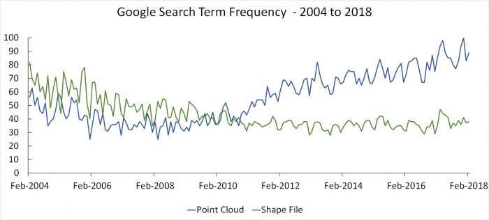
It is an exciting time to be in the field of GIS! The capacity to store large amounts of data and the steady evolution of remote sensing technology has led to some amazing advancements in data collection, analysis, and visualization. This is especially true when it comes to 3D-Data. A quick Google Trends comparison of ‘point cloud’ searches to ‘shape file’ searches reveals a steady increase in point cloud interest since 2010.