Is mapping really the ultimate equalizer?
When I was seven (7) years old, one of my favorite leisure activities was drawing the political map of my country, Ghana in West Africa, showing all then ten (10) administrative regions. I was very proud of my drawings (on hindsight, I should have had them framed). This map was a basic map which visually represented the administrative boundaries of Ghana on a piece of paper. However, mapping, defined as the creation of maps, is more than just the visual representation of various features of the earth drawn to scale. Maps can be used to provide spatio-temporal information, tell stories, gather “local knowledge”, can be interactive (modern digital maps like webmaps/webapps) and can facilitate problem solving and analysis as they can be used to identify spatial relationships.
Mapping is a very powerful tool and process. This is because people are either constantly mapping or consuming mapped information. Also, maps convey various meanings which can influence public opinions, and alter history while shaping the future. In the past, mapping has been used as a political tool to subdue, colonize, and re-conceptualize the identities of people and communities (e.g., the Indigenous communities in North America) by mapping new boundaries to alter already existing boundaries thereby almost leading to their erasure and threatening their sovereignty.
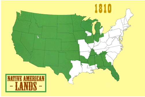
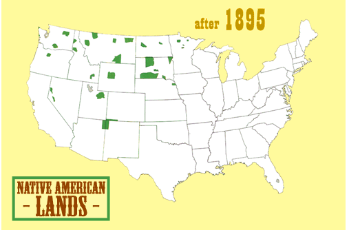
Native lands marked in green. Source: Vox.com
Contemporary North American societies are heterogeneous in nature, in terms of race, income, ethnicity, interests, values, etc., and mapping (which lends itself to be subjective – everyone can map from their perspective) can be used as an equalizer to allow these diverse interests to be expressed. This is important especially as current spatial planning practices aim at being collaborative in nature.
Therefore, mapping can be used as a democratic tool in a participatory process to capture diverse interests and opinions such as future development preferences, place attachment (affective bonds people link to various spaces), etc., to influence spatial planning decisions. The effectiveness of mapping in influencing spatial planning decisions depends on the willingness and extent to which authorities and planning experts, such as politicians, city officials, planning authorities, amongst others, adopt and integrate these mapped attributes during decision making processes to improve the quality of decisions taken.
In conclusion, mapping has the potential to be the ultimate equalizer to address societal inequalities, empower people, and promote democracy and inclusion. This can be used to correct errors of the past, sustain the present and provide for the future only if everyone is willing to be involved and tolerant of the diverse mapped views and perspectives in order to build all-inclusive societies.
Inspiration:
This article was inspired while listening to the plenary speaker for Day Two of the just ended GIS in Education and Research Conference, Mr. Steve DeRoy, CEO and majority owner of the Firelight Group.
Author
Robert Nutifafa Arku is a 2nd year Urban Planning Master’s student at the University of Waterloo. His research focuses on using participatory mapping to inform land use projects, specifically infill developments. Robert’s hobbies include playing musical instruments (bass guitar and piano) and playing and watching football