
Every summer, occurrences of wildfire across Canada causes not just environmental problems but also has serious health implications. This, coupled with widespread deforestation across the globe including region such as the Amazon Forest and Congo basin motivated me to participate in the 2023 Esri Canada GIS Scholarship for SFU competition. As an extension of my PhD research work, the intention was to develop and implement a spherical geographic automata modelling approach using a global hexagonal geospatial framework to simulate forest cover change and the process of deforestation at the global level.
Unlike conventional planer geosimulation models, the proposed model is based on the spherical geodesic grid which considers the curvature of the Earth’s surface when used for modelling and simulation at larger scales thus eliminating the effects of spatial distortions caused by planer map projections. The model utilizes hexagonal spatial tessellation thus providing a different cell typology from the commonly used square raster cells. The model also integrates the multi-criteria evaluation technique for identifying areas susceptible to forest cover change across the globe.
Several datasets with global extent are acquired to implement the model and all spatial datasets are preprocessed in ArcGIS Pro. The datasets are subsequently converted into DGGS format with each hexagonal cell encompassing 194.5 km2. Based on the scientific literature, several criteria are generated from the spatial datasets to represent the different drivers of deforestation at the global scale. Criteria considered in this study include proximity to urban areas, major roads, coastal and water bodies, past forest disturbances, as well as elevation, and slope. In the model evaluation phase, datasets for years 2000 and 2010 are used to calibrate the model and 2020 for model validation. The model is implemented and run for eight iterations with a temporal interval of 10 years to simulate global deforestation between 2020 and 2100. The spherical geographic automata model is implemented in the Python programming language using the DDGRID open-source library and other geospatial packages including geopandas, pyproj, cartopy and rasterio.
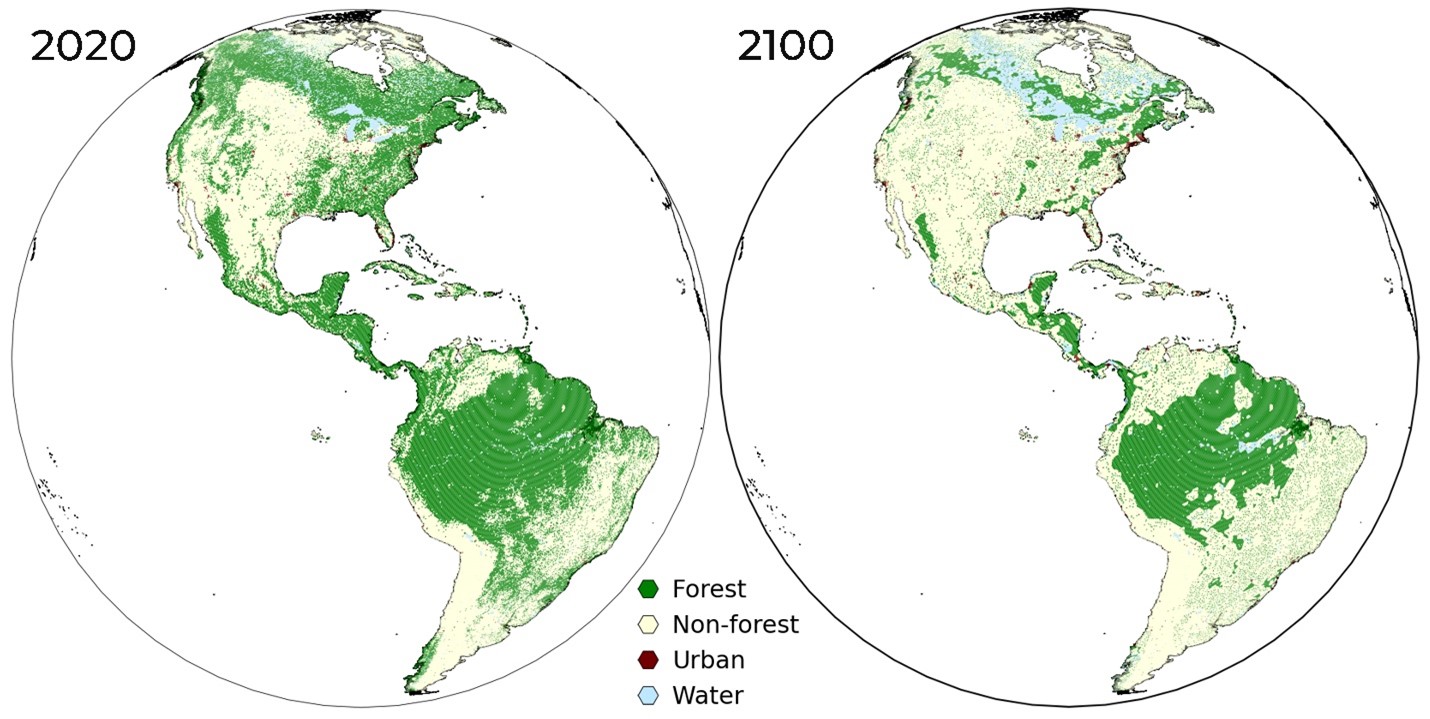
Based on the simulation outputs, deforestation begins from the fringes of large forest regions and diminishes into the interior. This spatial pattern can be justified where forest regions in proximity to past forest disturbances, urban areas, higher accessibility such as water bodies and road networks are more prone to deforestation. Over the course of the simulation run, regions initially covered by large forests become fragmented as deforestation spreads into the forest core.
The obtained simulation outputs of forest loss for year 2100 are presented for different parts of the globe in Figure 2. Simulation results from the model indicate global forest cover will decrease from 48 million km2 in 2020 to 27 million km2 by the year 2100 which corresponds to a forest loss of 44%. The spatial pattern and rate of deforestation differs across regions with the largest extent of deforestation occurring in Russia, Canada, United States, and Brazil. Between 2020 and 2100, 3.7 million km2 and 2.6 million km2 of forest could be lost in Russia and Canada, respectively. In relative terms, 54% of the forest cover in 2020 in Canada could be lost by the end of the 21st century based on the simulation output.
With the successfully implementation of the model, I was very pleased to obtain the 2023 Esri Canada GIS Scholarship for SFU. This has further inspired me to extend the current project into a full research paper with further improvements. Such enhancements include Improving the spatial resolution of the model to operate at a finer scale as well as including more relevant driving factors of deforestation in the susceptibility analysis. Also, three scenarios of deforestation were implemented to characterise future forest land-cover change trajectories under different conditions. This research work has successfully been published in the ISPRS International Journal of Geo-Information journal and can be accessed at https://www.mdpi.com/2220-9964/12/8/306.
Presently, I am working to build a web app for easy visualization of the results from the model using the ArcGIS JavaScript SDK.