

Setting the Stage
This year marked my first time competing in the annual Esri Canada Centres of Excellence (ECCE) App Challenge. I had the pleasure of forming a team with two Master’s of Geographic Information Systems (MGIS) students in the Geography Department at the University of Calgary: Chelsea Fitzpatrick (her account of the App Challenge can be found here) and Rhiannon Scott. What made our collective experience notable was the fact that we were all first-timers to the App challenge. We didn’t know what to expect, but we tried to prepare accordingly. At 5:00pm MST on our pre-determined start date of February 26th, 2021, a briefing document was released to us containing the topic for this year’s App Challenge and other rules that had to be followed to successfully complete the competition. The topic we had to address, using Esri technology and open data, was reducing inequalities within and between countries. The theme was chosen to align with the United Nations (UN’s) Sustainable Development Goal (SDG) #10. The problem we needed to address in our project, however, needed to focus on reducing an inequality within Canada. Having exactly one week from the start date to complete the App Challenge, we quickly held a team meeting, decided on a team name, and established a strategy for the remainder of the week. Rhiannon was the mastermind behind our team name: The ARCiTechs (Figure 1).
Choosing One Inequality Among Several
The most difficult part of the ECCE App Challenge, in my opinion, was deciding on which inequality within Canada to focus on in our work. In the last year and half, we have seen the impacts that the COVID-19 pandemic has had on people’s socio-economic well being and physical and mental health. The spread of COVID-19 between geographies has exacerbated the systemic inequalities that continue to exist across global society. Nested within the temporal bounds of the pandemic, also, has been the reaffirmation of the importance of human rights movements like Black Lives Matter. After many hours of critical discussion and research, our team decided to use the 2021 ECCE App Challenge as an opportunity to examine the inequality that Indigenous peoples within Canada face with their ability to access clean water for drinking and sanitation. While the UN’s SDG 6 is Clean Water and Sanitation for all, it is important to simultaneously address the inequalities that have led to people not being able to access a resource considered a basic human right[1].
I’ll be the first to admit that I take clean drinking water for granted; I can turn on the tap, fill up a glass, and drink without having to worry about bacteria or pollutants in the water. However, many Indigenous communities within Canada do not have the same luxury that other Canadians do when it comes to accessing clean water. Indigenous territories can be located adjacent to well-developed urban areas like Calgary, Alberta, but do not have the same services provided to them. This is an issue that has negatively affected the health and well-being of Indigenous peoples within Canada for generations, and concerningly, it remains unresolved. In fact, earlier in the year prior to our start date for the App Challenge, Canada’s Auditor General Karen Hogan issued a report stating that the Federal Government will not reach its goal of ending long term boil water advisories on Indigenous territories by March 31st, 2021[2]. Since then, several other articles have surfaced, documenting the issue that continues to persist and the progress required to permanently eradicate the problem[3,4,].
Esri Technology Selection and Approach to Application Development
Water treatment plants and more individualized purification systems can be expensive to install and monitor within Indigenous communities[5]. As a result, improving water quality for the Indigenous peoples of Canada requires significant and continued funding from the Federal Government. The success of water quality improvement programs over meaningful periods of time also depends on the completeness of Federal Government consultations with Indigenous peoples throughout all phases of infrastructure development. For this to happen, the problem needs to be better communicated to Canadians and governments. Not everyone is aware that this is a problem facing Indigenous communities in Canada. We determined that our best opportunity to contribute a solution towards the problem and make an impact with our work as part of the App Challenge was to communicate the problem in a geospatial format. Our motivation was to raise greater awareness around the issue, foster more discussion, and spark Canadians (governments and citizens) to take more serious action by making the data relatable geographically through an ArcGIS Dashboard.
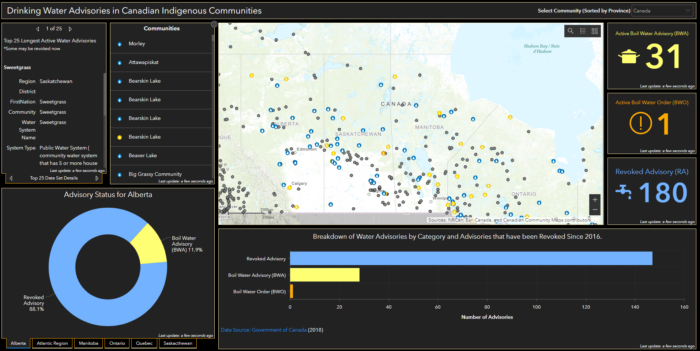
To make our dashboard, we first acquired relevant open data from the Government of Canada. One dataset contained all point locations of Indigenous band offices within Canada. The second dataset described the status of the water quality in places within Indigenous communities across the country. This data set contained point locations indicating three types of events: 1) A Boil Water Order (BWO), 2) A Boil Water Advisory (BWA), or 3) A Revoked Advisory for affected communities. We prepared the data in a map in ArcGIS Online, and configured a dashboard with a variety of widgets to display the geospatial distribution of the problem alongside high-level summary statistics (Figure 2). Personally, I gained interest in using ArcGIS Dashboards after first seeing the Johns Hopkins COVID-19 Dashboard at the onset of the pandemic in 2020. The advantage of using ArcGIS Dashboards, in my opinion, is that it presents the information in a user-friendly way and is easily customizable so that critical attributes of the data can be reported to end users. Our dashboard application, called kNOwH20, is configured to update as the Federal Government’s data is updated. It also grants users the ability to change the map extent, find out which Indigenous communities have been under water quality advisories the longest, and sort the data at the provincial scale. Overall, our dashboard contributes to reducing inequalities in Canada by better communicating to all Canadians the problem that Indigenous communities continue to face with their ability to access clean water for drinking and sanitation.
I encourage all readers to check out our dashboard application, the corresponding StoryMap that provides a more detailed overview of the problem as well as educational resources, and a live demo of the application linked from our App Challenge team profile on GitHub.
Challenges and Takeaways
This year’s App Challenge was unique to the competition in years past because as a team, we were unable to work on developing our application together in-person as one unit. As a result of the COVID-19 pandemic, we completed each stage of the App Challenge by collaborating over remote-work tools like Google Docs and Zoom. Fortunately, we were also able to set up a group for our team within our University of Calgary ArcGIS Online organization. This enabled our team members to contribute to iterative versions of the application while it was undergoing development. We found that the virtual work environment necessitated the prioritization and assignment of specific tasks to each team member to ensure all deliverables were completed on time. This resulted in team members taking on chunks of work that best reflected their personal and academic skill set. Parsing out the deliverables within our team, I think, contributed to our organization, time-management, and eventual success in completing the App Challenge with time to spare.
Within my research area as an MSc student, I mainly use ArcGIS Pro to work with geodatabases and shapefiles, make informative maps to use as figures in papers I write, and analyze data. Prior to taking part in the App Challenge, I didn’t have much experience using other Esri technologies, with the exception of ArcGIS Online. By participating in the ECCE App Challenge, I learned about the wealth of geospatial applications and software Esri has available, improved my ability to work with ArcGIS Dashboards, and expanded my knowledge about the media I can use to communicate the results from my own research to different stakeholders. In the near-term, I plan to take advantage of the educational resources and opportunities Esri makes available to us as ECCE Student Associates to broaden the ways in which I can deploy Esri’s software to support my own research. More importantly, however, the 2021 ECCE App Challenge was a fun way to spend a week with some fellow geographers, Chelsea and Rhiannon, while contributing a solution to serious problem. I look forward to participating again in the future, and thanks for the opportunity, Esri Canada and ECCE!
References
- UN Water. (n.d.). Human Rights to Water and Sanitation. https://www.unwater.org/water-facts/human-rights/
- Stefanovich, O., Roman, K., and Jones, R. P. (2021, February 25). Too many First Nations lack clean drinking water and it’s Ottawa’s fault, says auditor general. CBC News. https://www.cbc.ca/news/politics/auditor-general-reports-2021-1.5927572
- Goldfinger, D. (2021, March 5). Trudeau’s promise to improve First Nations drinking water years behind schedule: federal government. Global News. https://globalnews.ca/news/7836421/first-nations-water-trudeau-broken-promises/
- Cecco, L. (2021, April 30). Dozens of Canada’s First Nations lack drinking water: ‘Unacceptable in a country so rich.’ The Guardian. https://www.theguardian.com/world/2021/apr/30/canada-first-nations-justin-trudeau-drinking-water
- Beijius, W., and Patrick, R., J. (2019). “We Don’t Drink the Water Here”: The Reproduction of Undrinkable Water for First Nations in Canada. MDPI. Vol. 11, Issue 1079