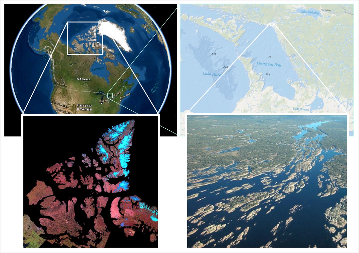
 Is the world’s largest freshwater archipelago losing islands? How water levels impact coastal marshes
Posted 3 years ago
By Sherry Chen in the McMaster Blog
An archipelago is a collection of islands. Canada is home to 2 of the biggest, a saltwater and a freshwater archipelago. The saltwater archipelago is in the northern part of Canada (> 35 K islands) that no one during geography class was able to fully draw. It is the world’s second largest saltwater archipelago. The […]
Read More
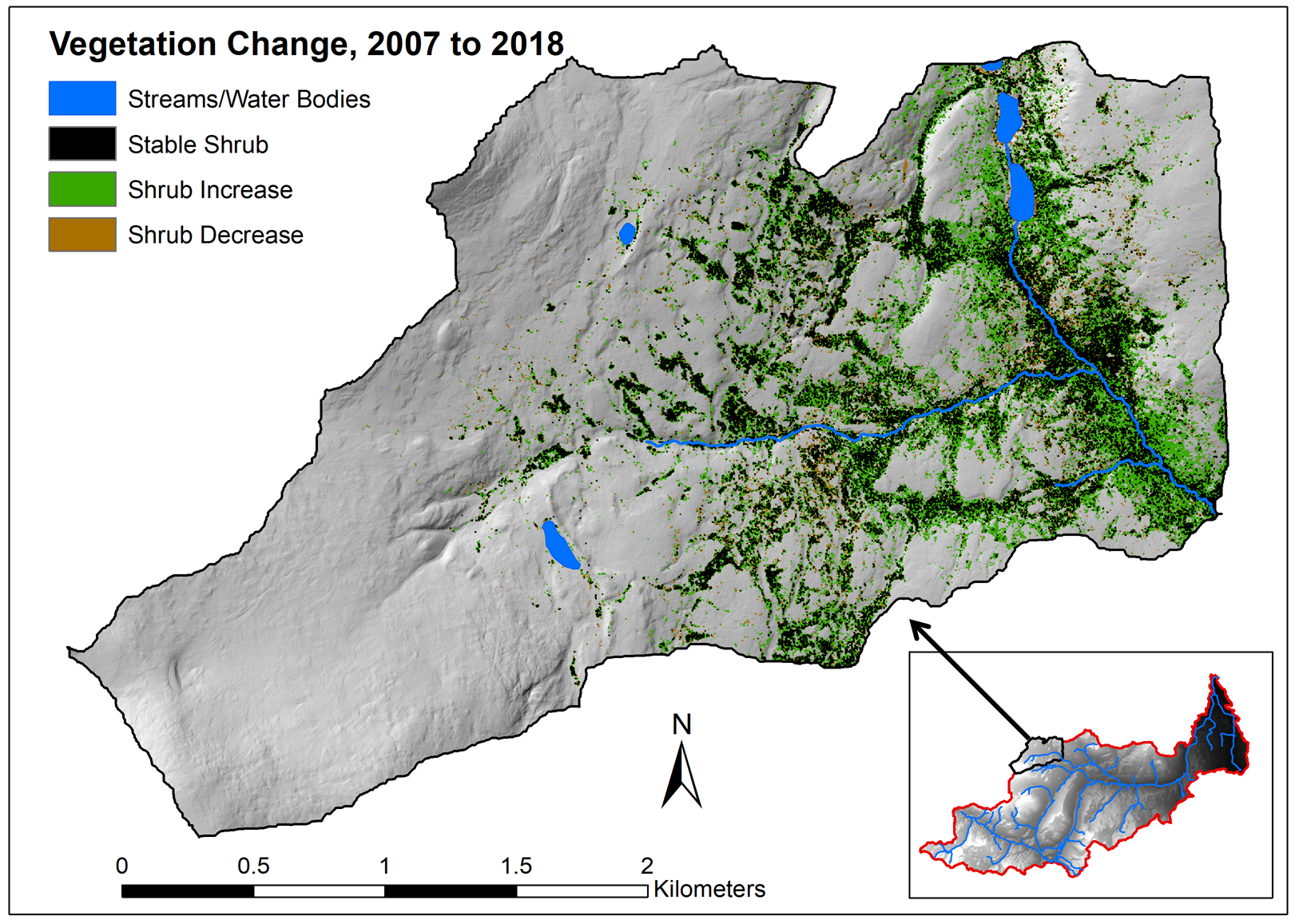 Evaluating vegetation change in Wolf Creek, YT with multi-temporal LiDAR: Part 1
Posted 4 years ago
By Sean Leipe in the McMaster Blog
In this post, I’ll be giving a summary of my current MSc progress in the McMaster Watershed Hydrology Group. This thesis project has two main components: using LiDAR and other remotely sensed imagery to quantify vegetation change over time in a subarctic research watershed, and comparing how these changes vary over different landscape properties. This […]
Read More
 Labeling Fishnets with Unique Codes
Posted 4 years ago
By Sherry Chen in the McMaster Blog
Purpose Fishnets are useful for a variety of projects and fields including conservation where it can be used to assign a reference code for unnamed sites and identify sites with a geographically unique name. The current fishnet tool in ArcGIS does not include a function to label each cell with a unique code. A tool […]
Read More
 GIS Summary of SNAP 2019 (Part 4): Multi-Criteria Data Analysis
Posted 4 years ago
By Todd Wong in the McMaster Blog
This is the last article in the 4-part series summarizing work completed by Todd Wong for the Stelida Naxos Archaeological Project (SNAP). For more background and steps leading up to the analysis presented in this article, refer to Part 1, Part 2, and Part 3. Introduction Multicriteria Data Analysis (MCDA) is a collection of formal […]
Read More
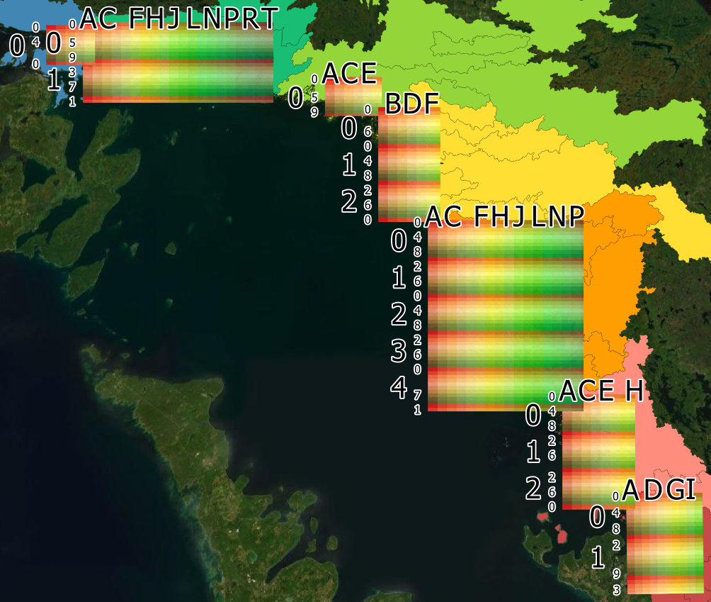
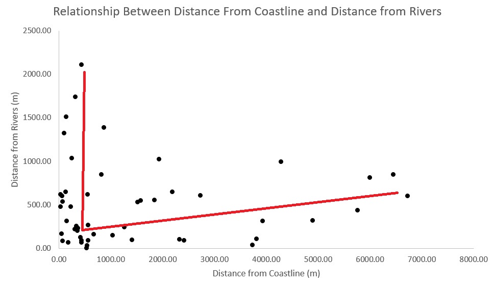 GIS Summary of SNAP 2019 (Part 3): Analyzing Extracted Results
Posted 4 years ago
By Todd Wong in the McMaster Blog
This third part of my four-part series will go through a case study in which we analyze and determine variables generated from several tools. Our case study involves 50 early bronze age sites on Naxos (Figure 1), an island located in the Aegean that is the largest of the Cycladic sister islands with a rich […]
Read More
 GIS Summary of SNAP 2019 (Part 2): Landscape Archaeology Analysis with ModelBuilder and Python
Posted 4 years ago
By Todd Wong in the McMaster Blog
Introduction Over the past few months I have been investigating a new methodology of finding settlement patterns using GIS. The current method of settlement patterns often involves deep research and field studies. In this report I wish to add a new element to settlement pattern analysis. This method can also add more information to landscape […]
Read More
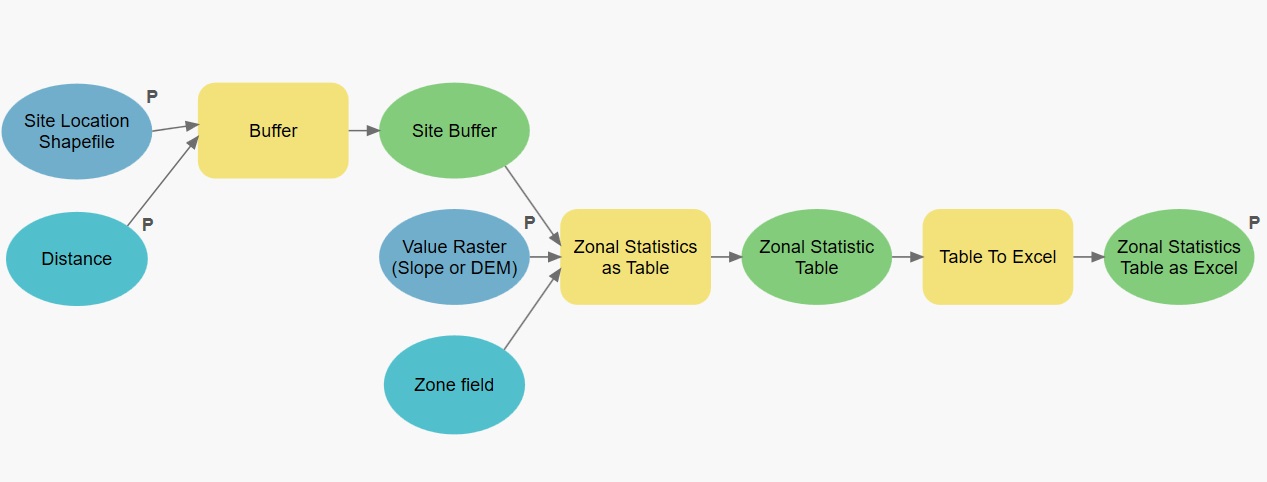
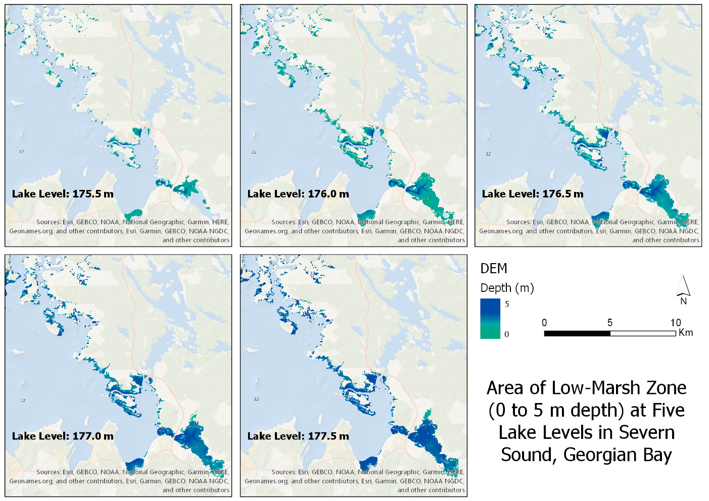 Clipping a Large DEM to a Large Shapefile and Getting Raster at Specific Elevations/Depths
Posted 4 years ago
By Sherry Chen in the McMaster Blog
When given the task of clipping a large DEM of Georgian Bay to a large shapefile of wetlands running along eastern and northern Georgian Bay at five different lake levels between specific depths, it led to more crashes than I expected. I found similar problems online and I want to show how I overcame it. […]
Read More
 Data Wrangling with Python and R, Part 2: LiDAR Validation with Differential GPS
Posted 4 years ago
By Sean Leipe in the McMaster Blog
One major part of my field season this past summer in the Yukon involved validating both of our LiDAR datasets with a differential GPS unit (dGPS for short). Independently quantifying survey accuracy is an essential part of any project involving LiDAR. Without knowing the LiDAR return accuracy in terms of elevation compared to the “true” […]
Read More
 Developing A Level of Traffic Stress (LTS) Network using R and ArcMap
Posted 4 years ago
By Rajveer Ubhi in the McMaster Blog
While cycling is a physical activity with recognized benefits, injury events do occur. Between 2006 and 2017, 890 cyclists died in Canada, averaging 74 deaths per year. Collisions with motor vehicles made up 73% of these fatal cycling events. In addition to deaths, about 7,500 cyclists were seriously injured every year during the same period […]
Read More
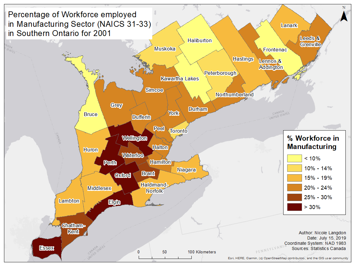 The Changing Landscape of Manufacturing in Canada
Posted 4 years ago
By Nicole Langdon in the McMaster Blog
This past summer I had the pleasure of working with a professor from McMaster University’s Labour Studies Department to map the labour sheds of manufacturing workers in populous parts of Canada. The intersection of a shrinking manufacturing sector, higher commute times, stagnating wages, and increased housing costs makes for a rich discussion of the ways […]
Read More

