 Pavement Marking Inventory using GIS and Computer Vision – Part II
Posted 10 months ago
By Omar Algiasena in the BCIT Blog
Aligned with the City of Surrey’s Digital Transportation Strategy, which aims to create a user-centric and data-driven Intelligent Transportation System, significant strides were made in 2022. The city collaborated with a student from the GIS Department at the British Columbia Institute of Technology (BCIT) to develop a deep learning model. This model automates the collection […]
Read More
 Attribute Driven Hachure Lines
Posted 10 months ago
By Nic Beauchamp in the Dalhousie Blog
Learning new mapping techniques is a great way to expand cartographic skills, and can increase one’s sense of balance and visual hierarchy for future endeavours
Read More
 Introduction to Discrete Global Grid System
Posted 10 months ago
By Bright Addae in the SFU Blog
Discrete Global Grid System (DGGS) have been proposed as a new geospatial technology and Earth reference system which utilizes a spherical tessellation of space to represent the Earth’s surface and is global in scope. The DGGS framework offers a discrete way for spatial referencing, using cells as the smallest unit of its base rather than […]
Read More
 From Digital Chaos to Structure: How GIS Taught Me the Importance of Data Management
Posted 10 months ago
By Molly Ingenmey in the COGS Blog
This blog post is a reflection on how over the course of this year I have learned to embrace data management, instead of disregarding it.
Read More
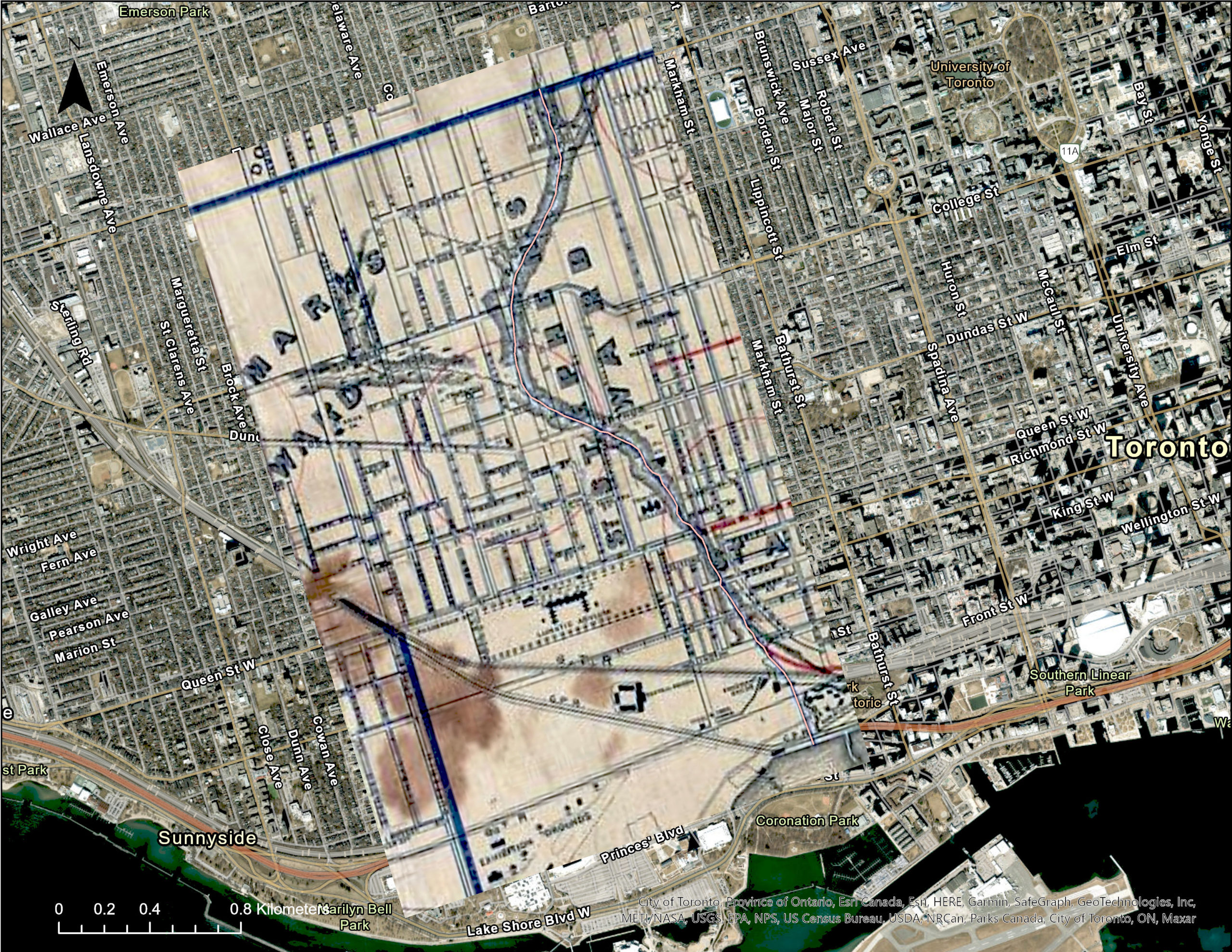 Exploring Historical and Modern Toronto With ArcGIS Pro
Posted 11 months ago
By Sarah Reeser in the UofT Blog
Visualizing historical and modern land use along lost rivers in Toronto.
Read More
 A Day in a Life of a GIS Intern at CBRE
Posted 11 months ago
By Junior Thiensirisak in the BCIT Blog
As a BCIT Advanced Diploma GIS student, part of the curriculum involves an industry sponsored project or practicum. Earlier this year, I was fortunate and grateful to start an internship at CBRE working with their Location Intelligence team here in Vancouver, BC. CBRE is the largest commercial real estate services and investment firm globally and […]
Read More
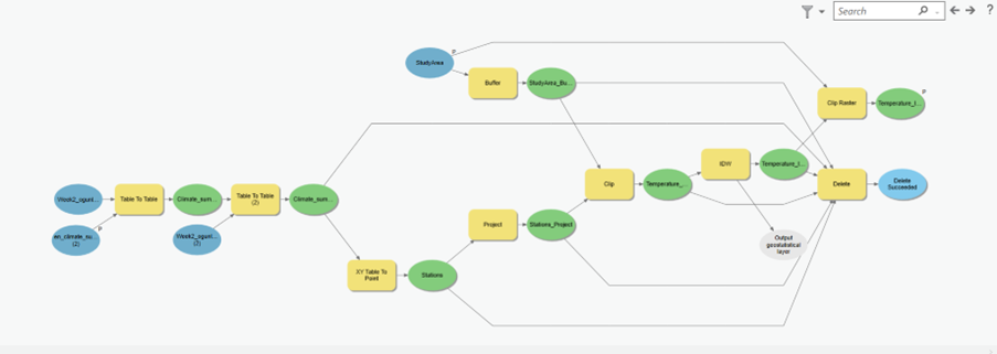 Working smarter, not harder, with ArcGIS ModelBuilder
Posted 1 year ago
By olusegun ogunleye in the UCalgary Blog
I was introduced to ArcGIS ModelBuilder during a course lab where we were asked to design a model which could enable the interpolation of temperature values for Alberta and Saskatchewan. Aside from ensuring consistency, efficiency, and effectiveness, the ModelBuilder aids the visualization of the workflow, allows modification by setting inputs and outputs as parameters, and […]
Read More
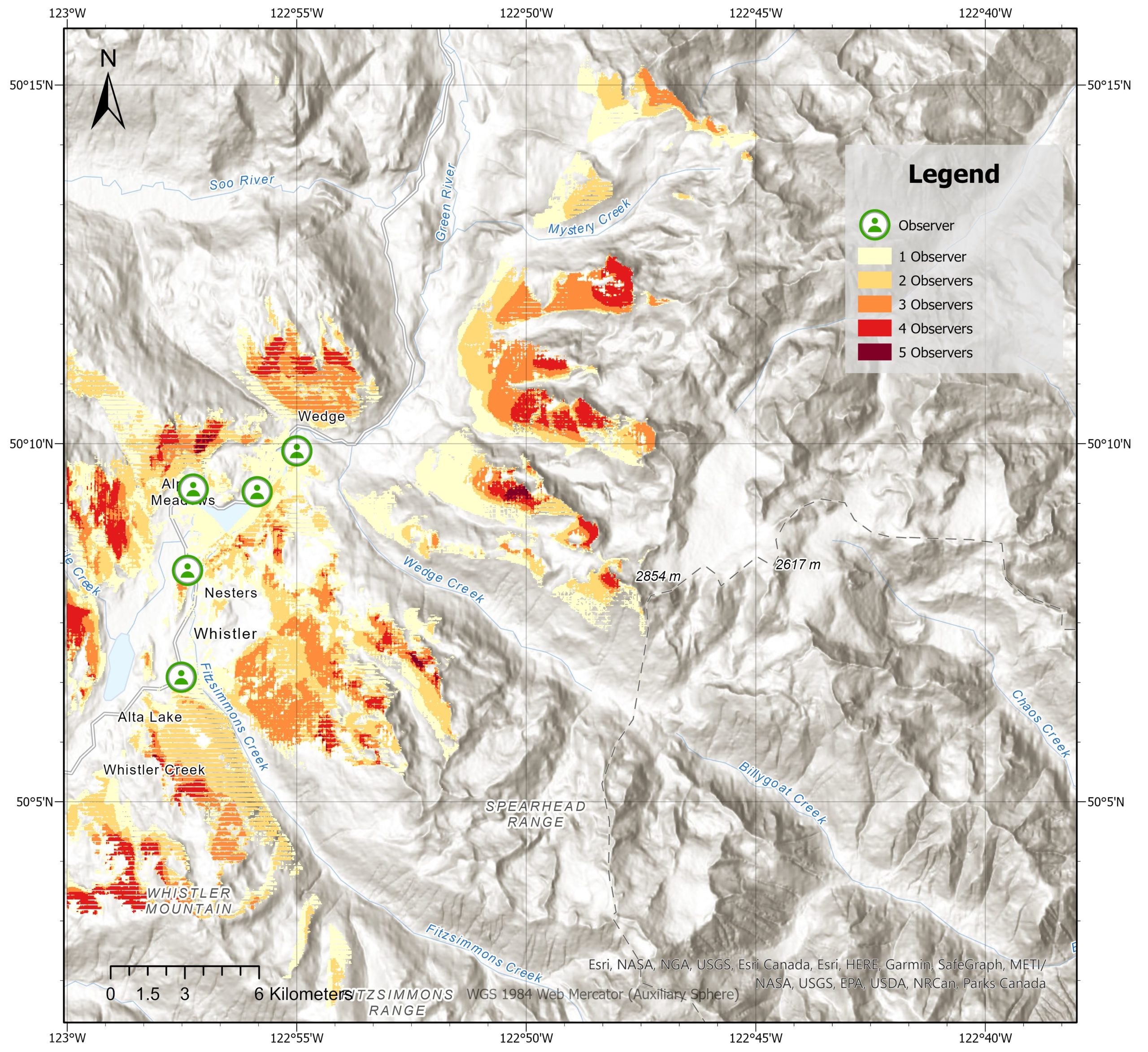 Analyzing Spatial Relationships in Mountain Regions: Visibility and Distance Analysis
Posted 1 year ago
By François d'Entremont in the COGS Blog
Are you ready to be blown away by the magnificent mountains of Whistler, British Columbia? Whistler is not only famous for its stunning landscape and outdoor activities but also for being an excellent site for analyzing spatial relationships. In this blog post, we will delve into the importance of visibility and distance analysis in mountainous […]
Read More
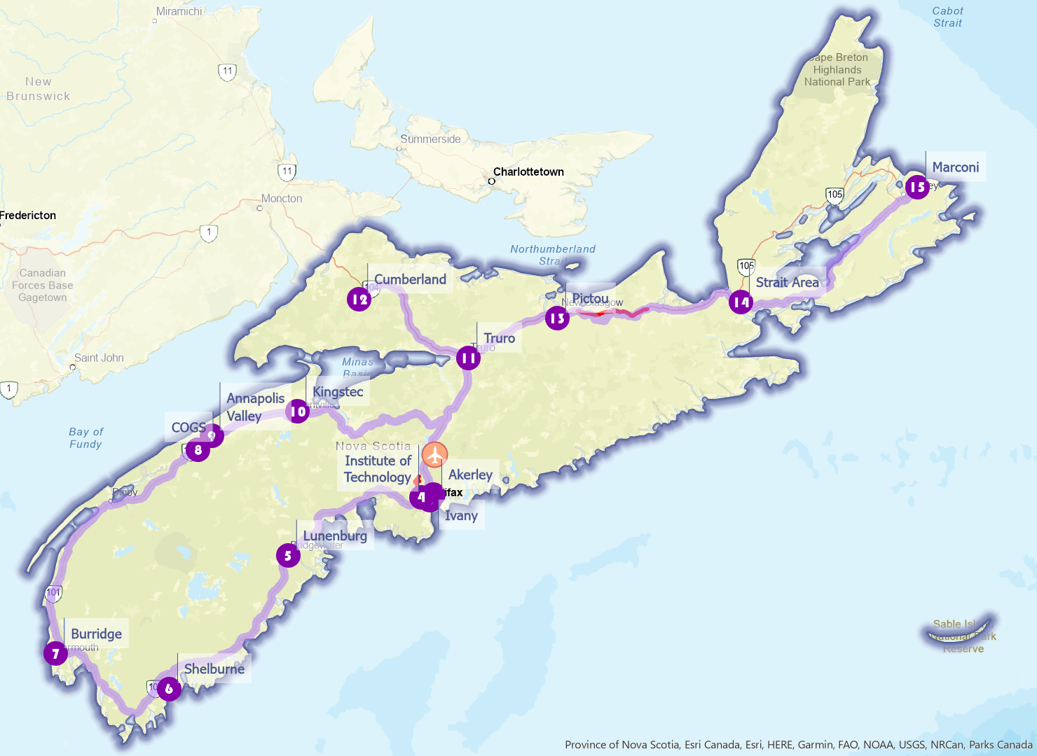 NSCC Campus Crawl – A Nova Scotia Route Optimization Guide
Posted 1 year ago
By Cindy Lu in the COGS Blog
In one of our Location Analytics course projects, we are asked to utilize ArcGIS Pro Network Analyst extension to identify optimal routes for subjects of our interest. Travelling has always been my passion, but logistics planning can be tricky: within a limited timeframe, how can one maximize their travel footprint? Given the landscape and infrastructure […]
Read More
 How to find frequently visited locations from human mobility data?
Posted 1 year ago
By Milad Malekzadeh in the Western Blog
One of the main steps in analyzing human mobility is finding the most visited locations of each person. In doing so, most researchers try to find locations where people spend most of their time. Whether we use a GPS tracking or mobile phone dataset, because of the errors pertaining to the underlying technology (e.g., atmospheric […]
Read More

