 Monitoring of seasonal changes in snow cover area in the Apex river watershed using ground camera and in situ observations.
Posted 6 years ago
By Yulia Antropova in the Carleton Blog
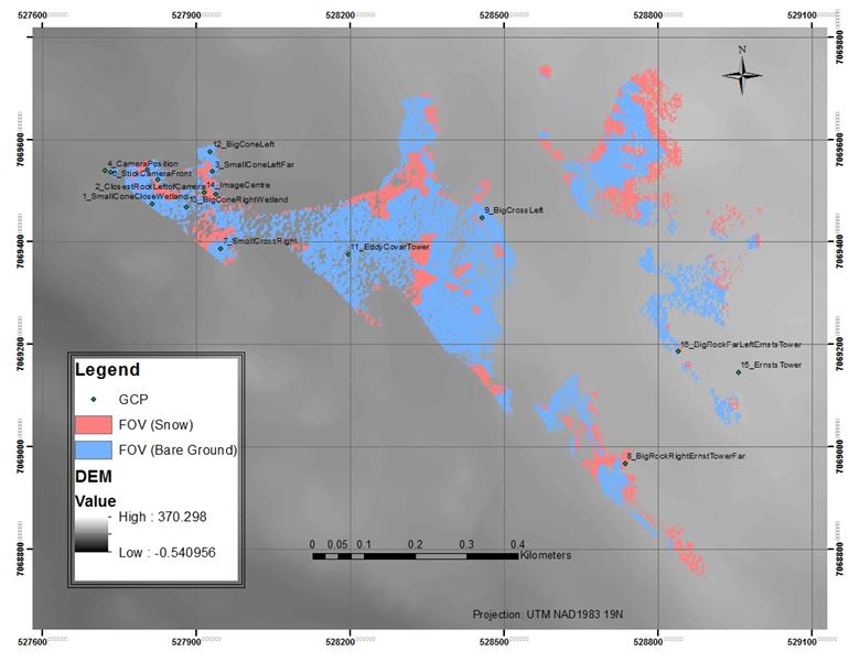
Monitoring of snow cover area in the Apex river watershed in Nunavut, Canada at different temporal and spatial scales is important to better understand and predict freshwater resource supply in that area. My previous post describes retrieval of changes in the snow-cover for a large area using MODIS 8-day composite snow cover products with a spatial resolution […]
Read More
 Pursuing a Graduate Degree in Geography
Posted 7 years ago
By Emily Lindsay in the Carleton Blog
Hello everyone! As a newly-minted ECCE member, in the spirit of fostering community and collaboration I would like to take this chance to briefly introduce my research interests and encourage all of you to consider pursuing graduate studies in geography. I am currently in the first semester of Carleton University’s Geography PhD program, and have […]
Read More
 Where is the Centre?
Posted 7 years ago
By Rafael Seyler in the Carleton Blog
Early this year one of my professors approached me and several other students to take part in a project that had to do with Ottawa. As the 150th Anniversary of Canada was looming in the not so distant future he’d been approached to cover the topic of what the centre of Ottawa really was. But […]
Read More
 Python script to retrieve time-series changes in snow cover area from MODIS
Posted 7 years ago
By Yulia Antropova in the Carleton Blog
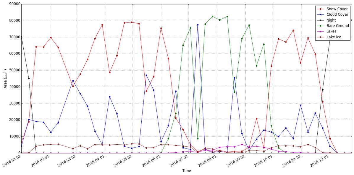
As a part of Directed Studies in Geomatics course supervised by Dr. Murray Richardson at Carleton University I developed a tool that allows a user to easily produce time-series plots of snow-cover area and other relevant pieces of information (e.g. bare ground, cloud, and night cover) for any region (defined by an input shape file) […]
Read More
Navigating GIS Without Computer Science Knowledge
Posted 7 years ago
By Jessica Smith in the Carleton Blog
I’m in my final push: 4th year at Carleton University. When I first started studying at Carleton, I had no idea what Geomatics was. A student who I met on my first day said he was majoring in Geomatics and the first thing I said was “ew”. But wait…I needed to meet a Geomatics requirement […]
Read More
 Collision Course: the daunting repercussions of an ever-increasing human race in coastal waters
Posted 7 years ago
By Danielle Derrick in the Carleton Blog
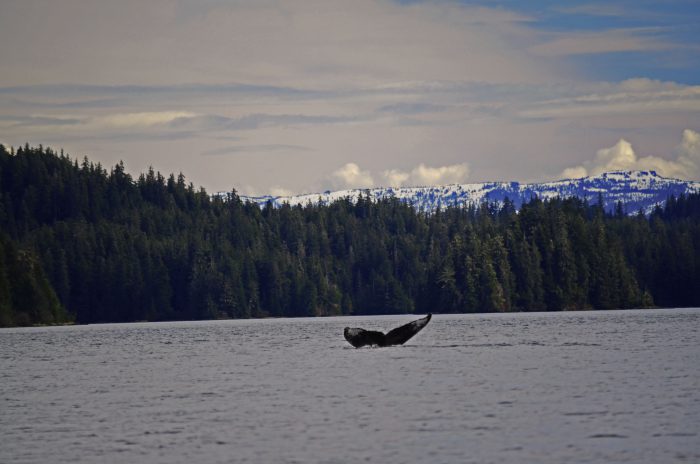
Looking out into Chatham Strait from Warm Springs Bay, Southeast Alaska. These past couple of months I’ve had the pleasure of working closely with the Alaska Whale Foundation (AWF) on both current and future research topics. AWF was founded in 1996 as a 501(c)(3) nonprofit organization dedicated to conserving Alaska’s marine mammals and their habitat […]
Read More
Using ArcMap for different mapping techniques
Posted 7 years ago
By Yulia Antropova in the Carleton Blog
Here I would like to discuss creation of maps in ArcMap using different mapping techniques. In particular I was able to easily create the following maps as a part of an assignment for GEOM3007 course: dot density map (shown in Figure 1), proportional symbol map (shown in Figure 2), and choropleth map (shown in Figure […]
Read More
LAS datasets and terrain dataset in ArcMap
Posted 7 years ago
By Yulia Antropova in the Carleton Blog
I took Geospatial analysis course in Fall 2016 term which guided us through different ArcMap tools useful for digital spatial data analysis. For my final project I choose to explore tools in ArcMap for processing data acquired by Lidar technologies. UAV-mounted Lidar technologies provide measurements of the distance between the UAV and the target which […]
Read More
Getting Started with Python – Dipping a Toe in Coding
Posted 7 years ago
By Rafael Seyler in the Carleton Blog
So last week I took part in the Getting Started with Python lecture offered here through Training. I’ve been in several coding programs in the past (Java, Html, VB, Python to name a few) but this course, though condensed to fit 8 hours, was top notch. I’ve found that with other coding languages they spend a […]
Read More
Examples of using NumPy to generate a near table
Posted 7 years ago
By Dan Patterson in the Carleton Blog
Generate closest features by distance ————————————- From near.py Emulating Generate Near Table from ArcMap Let us begin with finding the closest 3 points to every point in a point set. Well, that is easy… we just use the ‘Generate Near Table tool’. You have been spoiled. This tool is only available at the Advanced license […]
Read More

