
The Digital Humanities Summer Institute: Teaching GIS for the Humanities
This is a guest post by University of Victoria Ph.D. candidate Caty Brandon, about her experience with the Digital Humanities Summer Institute in which she helped introduce humanities researchers to GIS.
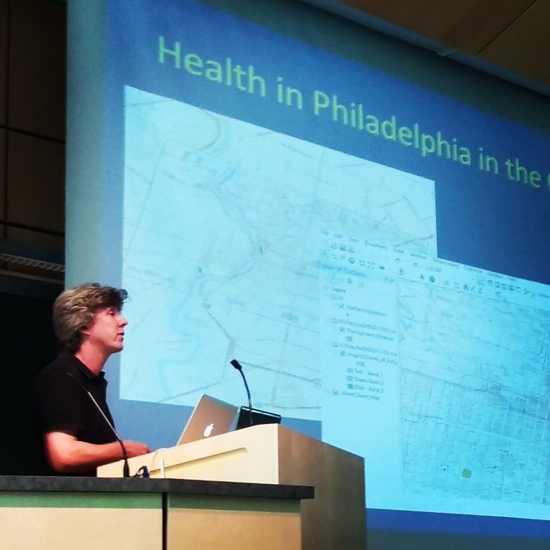
The University of Victoria has been hosting the Digital Humanities Summer Institute (DHSI) since 2001. DHSI hosts one-week courses in a variety of digital and technologically innovative research areas for the humanities. One of their courses is a week-long introduction to GIS using Esri’s ArcGIS Platform. Participants learn the most relevant GIS techniques for English literature, history, and other humanities applications of GIS. The course is taught by Dr. Ian Gregory of Lancaster University (UK), who is one of the world’s experts in the use of GIS for humanities projects. This is the second year in a row in which I have acted as a teaching assistant to Dr. Gregory. Nearly 20 professional researchers, academics, and students joined us during the week of June 15 – 19, 2015 to learn how they could use GIS for their own projects.
One of Dr. Gregory’s more well-known projects is an English literature application of GIS to spatially analyze the textual accounts of tours of the Lake District in England. The project, which is called “Mapping the Lakes”, introduces a visual spatial context for interpreting texts by Samuel Taylor Coleridge (1802) and Thomas Gray (1769), allowing us to experience the text by following the author’s journey across the landscape using map-based representations. It also allows us to identify spatial patterns in the writings to understand the preferences of the authors and their travel. This has a variety of applications for re-imagining historical writings rich in landscape/place information and metaphors.
Using GIS for humanities applications can involve using different techniques and functions than what are normally used for environmental and natural sciences. Therefore, the one-week GIS course has been tailored to introduce researchers to a variety of common and useful GIS techniques that support them in humanities applications. Basic cartographic principles, spatial database creation, and management, querying, and overlays are taught. In addition, georeferencing of historical maps, which are often crucial artefacts used by humanities researchers, is taught to add digital spatial referencing to a previous non-digital map. This helps bring historical cartographic representations into the modern digital age and allows us to experience history through the melding of new and old cartographic representations.
In addition to the tutorials, students are given two half-day periods to work on their own projects. Many are just in the beginning stages of setting up a GIS project and understanding the data that are needed to develop spatial representations of their work. A medical geographer from Philadelphia came to map medical care networks from a 19th century Philadelphia hospital and other affiliated institutions. Another researcher from Texas Christian University was there to map the “imagined south” according to place names from southern cookbooks (e.g., famous South Carolina chef Sean Brock’s cookbook) during the project work days at DHSI. A third researcher mapped child mobility from Peru to Spain for the years 1545 – 1570, in which children from Peru were sent back to relatives in Spain and Portugal to be raised as Europeans. Many of the participants were creating their databases for the first time, with no previous experience visualizing their work spatially with maps.
As the teaching assistant, being involved with the DHSI has been a very rewarding experience, as the students are professionals excited about developing new skills to represent their research visually. I’ve also been able to add to my own skill set acting as a teaching assistant for a humanities context, whereas I normally work with marine spatial data. If you are interested in learning more about Digital Humanities, dates for the 2016 course have already been scheduled. More information can be obtained at http://dhsi.org/. Thank you to Dr. Ian Gregory for leading the course, and to the students who come each year!