
Flood risk analysis of Chilliwack, B.C., Canada
In November 2021, a large flooding event happened alongside the Fraser River in lower-mainland B.C. and lasted for several weeks. The city of Chilliwack was among the most devasted cities. That being the inspiration, I designed an MCE research framework to assess flood risks in Chilliwack in B.C. and categorizes areas of the city into three different risk levels by using an MCE analysis in Esri ArcGIS. The MCE method has been combined with analytical hierarchy process (AHP) and weighted linear combination (WLC) technique to obtain the flood risk levels.
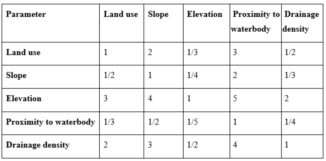
The work incorporates five different criteria: land use, slope, elevation, proximity to water and drainage density. The weight for each criterion is calculated through the analytical hierarchy process (AHP) method based on their impacts and importance on flooding events (Table 1). The value of 1 is considered as equally important, and 9 is considered as strongly important. For example, comparing “proximity to waterbody” with “land use”, “land use” is a slightly more important factor to flood propagation. As such, a value of 5 will be assigned to “land use” relative to “proximity to waterbody”.
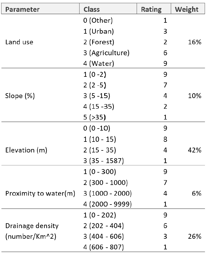
The weighted linear combination (WLC) method is used to account for the influence of the attributes on flood propagation (Table 2). For example, in the land use section, flood spreading will be limited in forest areas because of trees’ natural resistance to water, therefore forest will be assigned a low rating of 2. These weights were informed by personal experience and from literature searches. The obtained flood risk values are then divided in three different risk zones providing the information of the level of risk.
The obtained results are the flood risk values that have been generated for each raster cell for the entire study area. They have been classified in three equal intervals to represent three risk levels from the lowest (level 1), medium (level 2) to the highest (level 3). Figure 1 presents the map of risk levels. Areas within the City of Chilliwack that are not classified into either of the risk zones are considered risk-free areas or safe zones from floods. These areas are on the higher elevations. The 3D map (Figure 1) representing the configuration of the terrain has been created for improving the visualization of the areas most prone to flooding.
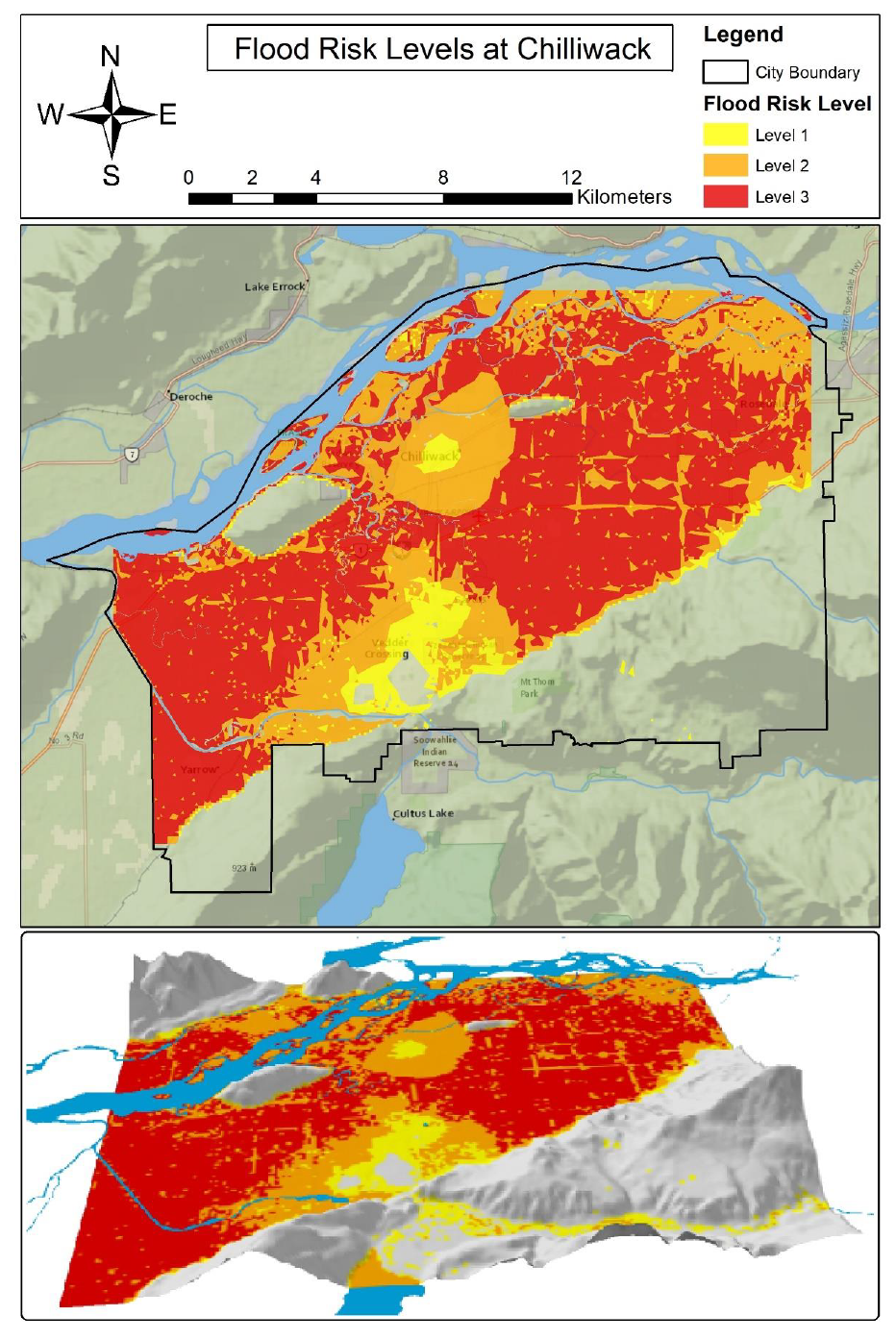
From the results, 34.7% of the City of Chilliwack is in the highest level of flood risks. This is not surprising, as most of the city are at the same elevation as the Fraser River. For the agricultural land use, 77.6% is at the highest risk to flood, while urban land use is at 4.1% and forested land use is at 7.9%. This can be explained by the agricultural land being at the same elevation as the river but also far from dense drainage networks, while urbanized have the highest density of drainage. Overall, 34.7% of the entire City of Chilliwack region is in the highest risk (level 3) of the flooding risk while level 2 and level 1 cover 23.6 % and 4.6% respectively, and 37.2% of land is not at risk to flooding.
Overally, I really enjoyed the process this work. It gave me a taste of how a scientific research should be done, and now I am motivated to learn more about GIS and Spatial Analysis in my MSc Studies that begins soon. Luckly, this work was selected by Simon Fraser University’s Esri Higher Education GIS Scholarship 2022, and I want to specially thank Dr. Suzana Dragicevic and Dr. Shivanand Balram for the help and guidance they provided. I am including the scholarship poster in the end of this blog.